SATELLITE IMAGES

Cap'n

Greenie
Feb 15, 2021
12
16
Primary Interest:
All Treasure Hunting
So how/where does one go to source Lidar imagery of a given area? I have an area I'd like to metal detect but this certainly sounds like the place to start on the macro side of things?
 

Cap'n

Greenie
Feb 15, 2021
12
16
Primary Interest:
All Treasure Hunting
Is there a site where I can pay for LIDAR satellite imagery?
 

Red_desert

Gold Member
Feb 21, 2008
6,852
3,502
Midwest USA
Detector(s) used
Garrett Ace 250/GTA 1,000; Fisher Gold Bug-2; Gemini-3; Unique Design L-Rods
Primary Interest:
All Treasure Hunting
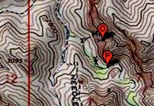
I found a mapper for gps coords on old topo chart land and sea. I tried getting gps off 2 zoomed in GE satellite images for same location looked at on IR satellite (Needle Cayon IR}. The top pin almost covered up word MINE.
 

Attachments

  • Map_Topo_NeedleCanyon_1Crop.jpg
    Map_Topo_NeedleCanyon_1Crop.jpg
    373.6 KB · Views: 37
OP
OP
Salvor6

Salvor6

Silver Member
Feb 5, 2005
3,755
2,169
Port Richey, Florida
Detector(s) used
Aquapulse, J.W. Fisher Proton 3, Pulse Star II, Detector Pro Headhunter, AK-47
Primary Interest:
Shipwrecks
Hello A-RON, yes, I would like to see that klm file that you got from Okie Send it to my email address: [email protected]. We also use data that Issac sends us. I will text you later on this afternoon.
 

Top Member Reactions

Users who are viewing this thread

Top