Help with possible trail markers along a river!!

ghost_rider

Jr. Member
Apr 20, 2008
82
6
I am somewhat new to the hunting of trial markers and this week while on vacation I did some hiking in a very historic area.

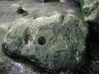
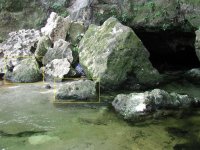
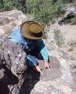
While stomping around I located a unique pile of rocks at the mouth of a cave along the river I was hiking. There are two larger rocks that are about three feet from each other, both having unique and unusual carving. I guess I should note that the cave has a fresh water spring flowing from it, you can't miss it if you are crusing along the river!!!!

You can see these in the two photos below, the first you will note a large "V" notch carved into the top of the rock with a large hole to the lower left of the notch. The hole may be natural but I am very suspect of the "V" notch as it doesn't seem natural.

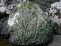
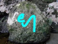
The second photo shows the rock laying three feet from the first photo. This rock appears to may be have some directions with the number 4 below, I suspect this to be a map of the river showing a couple of bends up or down stream.

I was hoping that someone could help me identify and interpret these signs if they are signs. PLEASE NOTE: there are several modern carvings in these rocks as well, these modern carving consist of people's names who have swam in the river at this location..... I identified the name KRIS and other letters that were too worn to read. The marks in the photos are the only ones I suspect to be trail markers.

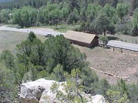
I will post a wider shot of both rocks if need so that the entire enterance to the cave can be seen.
 

Attachments

  • P1010252-c.JPG
    P1010252-c.JPG
    70.9 KB · Views: 775
  • P1010253-c.JPG
    P1010253-c.JPG
    70.9 KB · Views: 759

Highmountain

Hero Member
Mar 31, 2004
616
33
New Mexico
Hi Ghost Rider: Puzzling rocks you've found. I don't know what you have there, but I think judging from the patina the marks might be older than you're figuring. I don't know how long it takes patina to form that close to the water, hopefully someone else will be able to help on that.

But you have two distinctly different sets of marks separated considerably by time. The left depression with the leaf in it would be the oldest and probably the weirdest because it looks much the way a rock will look after a projectile strikes it at an angle and glances off, taking out a path of rock along the exit route. I first noticed this back in the 60s while attending the University of Texas. Half the stone walls on the campus still have similar, though smaller depressions from bullet-strikes from the Charlie Whitman event. You can actually examine them and trace the general path of the bullet incoming and exiting. You can even see similar strikes on the walls at the top of the tower from the strikes where the police were shooting at him.

Similarly, at Massacre Canyon in the Black Range you can generally follow the course of the shooting and who was hiding behind what rocks by those kinds of depressions.

The only place I've ever found any as big as the one in the picture is Glorietta Battleground, where small arms, cannister and artillery all left a record of who was hiding behind what.

Seems unlikely in the extreme, but that left depression would pass for some at Glorietta.

I believe the depression next to it is also deliberate, but much later, still not 'modern' because of the patina. The surface of the rock has been flattened and smoothed and, amigo, that took a lot of effort and time by someone. Having said all that, I don't know what it means.

Second pic depicts a what? symbol? I don't know, but I can tell you I found one similar, if not identical on a mountain in western new mexico a few years ago. Never figured out what to make of it. I agree the notch is part of the package.

Good luck
Jack
 

Attachments

  • Image2a.jpg
    Image2a.jpg
    72.4 KB · Views: 708
OP
OP
G

ghost_rider

Jr. Member
Apr 20, 2008
82
6
Please also note the number 4 carved right under the sign you have highlighted, I think this may actually be apart of the pile.

I surely hope someone can offer some insight on the symbol.
 

OP
OP
G

ghost_rider

Jr. Member
Apr 20, 2008
82
6
I will be honest with you... I didn't think to check the cave at all but the water was also a little high to check. The cave is very unique as mentioned it has a fresh water spring flowing from it. You enter the cave and come to an opening where it opens up to the ground above and the sun is shinning down, there are four seperate locations where you go under ground and then it open back up to the sun above. All the way at the end, or the fourth opening the cave goes down and the water is bubbling from below, this is an entire wet cave and would have to be dove.

The underwater floor of the cave, as you go back in, is a mix of sand and large rocks just as those piled at the front and in the photos. This is a very popular swimming spot and I know there are mondern carvings in the rocks but these are certainly not modern as they make no sense, most of the modern carving are names. In addition the modern carvings are very shallow and are simply scratched into the rocks, the symbols are very deep and took a lot of time to carve.

Here is a photo of the entire enterance to the cave, you can see the two rocks with the carvings. Notice the huge heart shaped rocks at the enterance, it an upside down heart!!!! I didn't notice this unitl looking at the photos later.

I highlighted the two rocks with the carvings in the previous photos!!! Perhaps these are Indian although this area has seen Spaniards and lots of Civil War activity, take you pick as to who put it there!!!!
 

Attachments

  • P1010251-c-notated.JPG
    P1010251-c-notated.JPG
    99.6 KB · Views: 727

Highmountain

Hero Member
Mar 31, 2004
616
33
New Mexico
Thanks for posting the third pic and additional info. I'm going to think about what you've said a while, got some ideas nagging at me but they'll only be ideas when they gel. I don't know nuthun to speak of though I've studied symbols a lot and found a lot of them on the ground.

For what it's worth I'm going to post a pic to illustrate what I was referring to insofar as the projectile strikes. This was taken at Glorietta battleground, not a good pic but I can't find my files with the good ones. There were snipers up there and one was killed behind those rocks, his name is documented though I don't recall it. This is above Pidgeon Ranch on the left flank of the Texans, Fort Union troops occupied this spot and the ranchhouse below during the early part of the battle. Several Texans were found buried in a mass grave almost immediately below this spot maybe 100-150 yards away during the 1980s.

That rock face and the pocks identify most of the positions on the ridge after all this while.

Sorry to digress the thread but I think a lot of folk don't know how helpful it is to be able to use this to locate positions where people were being fired at... It can lead to all manner of things where folks were forgetting them in the heat of battle.

But I honestly think there's a good chance that pock on the left in your pic was made by a field piece projectile.
 

Attachments

  • glorietta ricochets.jpg
    glorietta ricochets.jpg
    89.6 KB · Views: 712
  • glorietta from the ridge pidgeons.jpg
    glorietta from the ridge pidgeons.jpg
    79.8 KB · Views: 698
OP
OP
G

ghost_rider

Jr. Member
Apr 20, 2008
82
6
Any thoughts or opinions are welcomed, I would just like to know if the area is worth checking for anything or not. I'm not one to get pissy if it isn't what I think it may be!!! :D

I just wonder if it isn't pointing to somewhere upstream, perhaps the deep groove in the rock will sight you to the next symbol or sign, although the "4" under the other symbol is nagging at me.

I would not doubt that these rocks have been fired upon during the Civil War. There were a large number of blockade runners and union boats up and down this area, there was a ferry down stream from this location as well as a Confederate earthworks.
 

djui5

Bronze Member
May 22, 2006
1,807
293
Mesa, AZ
Detector(s) used
None
Primary Interest:
Prospecting
Looks legit to me. I'd search for a hill that looks like the "A" in the 2nd picture :) Nice find. The cave probably means nothing, but who knows, maybe it was cleaned out.
 

CanadianTrout

Hero Member
May 21, 2007
728
43
Canada
Detector(s) used
Ace 250
stilldign said:
You are being lead to a treasure room that's been set up to the book of John. Look for th eagle and the owl.

Oh man come on. Stilldign, what the h3ll u talking about? I'm not trying to nitpick or anything but I want to understand what is behind you making such an assertive statement as your first sentence. To throw that out there with no explanation does not help the guy asking about his pics. Seems to me you're just fishing here or "seeding" the thread.

Please tell me, I want to believe, what lead you to that conclusion? I assume by posting here you want your 2 cents heard and have something constructive to contribute. I've seen and heard of eagles and definitely seen owl carvings; please explain your first sentence for everybody. Especially ghost_rider. Thanks man.
 

OP
OP
G

ghost_rider

Jr. Member
Apr 20, 2008
82
6
Is there any significance to the number "4" below the symbol on the second rocks. I am thinking that the "A" hill may be associated with the number "4" below..... this hasn't been highlighted but if need I can do so.

Thanks for the help!!!!
 

Highmountain

Hero Member
Mar 31, 2004
616
33
New Mexico
ghost_rider said:
Is there any significance to the number "4" below the symbol on the second rocks. I am thinking that the "A" hill may be associated with the number "4" below..... this hasn't been highlighted but if need I can do so.

Thanks for the help!!!!

I think I might be tempted to look at it simple and obvious first before getting too complicated. I'd probably think of the cavity on the rock as representing the cave entrance and the #4 as the 4th opening in the cave. That would lead me to to use the cheapest and whatever's-most-available-to-me means of viewing the underwater floor area at the 4th opening, such as a video camera with a light [if needed] protected and submerged on a rod. I think I'd also take a close look at the walls and ceiling around the 4th opening.

Looking around the openings 2, 3, and 4 for other hints worthwhile might provide some more hints if they have any markings outside them also. And trying to related the shape I highlighted with anything inside the cave, be it shape of the tunnels, shape of something on the walls or ceiling inside, markings inside, anything at all might add something if the cave has something to do with things.

Seems to me it's assuming a lot to think the markers being so close to a cave entrance is just a coincidence. I'd tend to assume the opposite because it's easiest to check, then once it's examined and discounted I'd go on to look for other clues. It's possible the person or people who had something worth all the trouble of marking up rocks weren't familiar with symbols and codes used by others and just wanted to be able to tell someone how to find the place without having to go back themselves.

Just guessing.
J
 

OP
OP
G

ghost_rider

Jr. Member
Apr 20, 2008
82
6
Thanks for all of your great interpritive work.... what would the distance be for the diamond symbol.

I certainly think this may be the beginning point of a trail and that the covered tunnel may be somewhere on land or along thr river.
 

CanadianTrout

Hero Member
May 21, 2007
728
43
Canada
Detector(s) used
Ace 250
stilldign said:
ghost,
The "4" is telling you that the site is set up to the fourth book in the Bible, the Book of John. The symbol for John is the "eagle." The "M" in one photo is telling you that the owl (the owl of "M"inerva) will also be there to guide you.
The "A" is a direction indicator and the diamond is giving you distance. The groove in the top of the rock, if you look closely enough, will have signs showing you where this covered tunnel is located.
Rivers and waterways have long been used to locate treasure rooms. It was the main source of travel. Any canadian trout should know this.

Sorry I forgot about this post. I totally agree about the use of rivers in those days. They were natures "highways" back then for their ease of travel over long distances of harsh terrain.

Thanks stilldign for filling in the info I was asking about. That's what I was looking for. Who specifically used these bible references and trail/treasure markers? Is this a Jesuit thing? KGC or Spanish? Or all of the above? Thanks again.
 

OP
OP
G

ghost_rider

Jr. Member
Apr 20, 2008
82
6
I have been working with a couple of others on this and they are pretty sure this is KGC.... I will be back in that area and working with these symbols during the first week of July.... we have a pretty good lead with it that will be put to the test.

I'll try to keep the forum posted!!!
 

Top Member Reactions

Users who are viewing this thread

Top