RayHeezy
Jr. Member
- Mar 26, 2014
- 91
- 384
- Detector(s) used
- Ace 250
- Primary Interest:
- All Treasure Hunting
Thoughts? Unsure of what island it could be, too many match that description. Worth chasing down this kind of site?
I was keying in on the first location. Pine Island is 17 miles long, so unfortunately I don't think it's quite that easy.Could be Pine island, although it is westerly of the Harbour and probably like two miles in length. The other settlement may have been any creek near Sarasota....Phillipi creek, Dona Bay, or a host of others. It was described as being between the Manatia River and charlotte Harbor. That Manatia river was most likely the Little Manatee River and not the Manatee River as it was called Oyster River at that time period. Lots of ground to cover to find that settlement that now sits under modern homes and roadways.
Correct.I think Juan Gomez had settled panther key but i think that was in his later years, and he and his wife lived alone there. My reference to Pine Island was meant to be two miles wide....not long. Perhaps if the fellow did not know east from west, he may have not known length from width, or one mile from two miles.
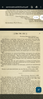
I can't quite make out what it says just above the words pine Island. I also didn't realize Sanibel had a town large enough to denote such large bold writing back then.I think that in order to see more of what the teller of the settlement actually saw, it would be best to see the area as it was contemporary to the time he saw it. Here is John Lee Williams map from 1837, just a few years after the settlement was spotted. Williams map is highly respected for accuracy for he actually visited Florida and made extensive notes on its geography... View attachment 2136595
The cistern, farm machinery, small dock are there. It is a designated campsite so you can camp there. It’s a pretty good ride to get there. IMO I would plan your trip very soon. The best time I found is right after a big northern cold front blows thru in early spring, no skeeters. If you wait any longer we have been there where the skeeters were so bad you couldn’t even get out of you truck. Seriously the Glades can be a paradise or a trip thru hell.I can't quite make out what it says just above the words pine Island. I also didn't realize Sanibel had a town large enough to denote such large bold writing back then.
I love reading the history of this area and then going on a walk or adventure and think about the things that were happening on the same ground I stand on.
Flipper, I'm familiar with most of the names and places on your list, roughly, and have a trip to Watson's place set up this summer. I hear the cistern is still there. Would love to get feet on the ground in First Bay, maybe a shallow water detector dive. Unsure if that's fair game out out there.
Yeah, you are in the Park Boundary. Detecting off limits. Last time we were at the Watson Place a Ranger cruised by so their out there. Most of the wildlife is gone just like everywhere else.I heard Ian destroyed the dock. Does normal state law apply to shallow water detecting out there?
I can't quite make out what it says just above the words pine Island. I also didn't realize Sanibel had a town large enough to denote such large bold writing back then.
I love reading the history of this area and then going on a walk or adventure and think about the things that were happening on the same ground I stand on.
Flipper, I'm familiar with most of the names and places on your list, roughly, and have a trip to Watson's place set up this summer. I hear the cistern is still there. Would love to get feet on the ground in First Bay, maybe a shallow water detector dive. Unsure if that's fair game out out there
The little island above pine island is marked "Taompe Island or Caldes"...of interest may be what John Lee Williams noted in his book as he explored the coast. He described it as being 1 mile long, and was inhabited by the Calde family,perhaps the bad ones.I can't quite make out what it says just above the words pine Island. I also didn't realize Sanibel had a town large enough to denote such large bold writing back then.
I love reading the history of this area and then going on a walk or adventure and think about the things that were happening on the same ground I stand on.
Flipper, I'm familiar with most of the names and places on your list, roughly, and have a trip to Watson's place set up this summer. I hear the cistern is still there. Would love to get feet on the ground in First Bay, maybe a shallow water detector dive. Unsure if that's fair game out out there.
Beautiful information! Which John Lee Williams book did that come from? I have multiple in my next thrift books order lol. I feel like I've heard of the Caldes family before, but can't quite pinpoint where. Looking at updated maps currently to try and figure out one that matches the description in your book. Being in that pine Island sound, most definitely off limits on land, but I'm a fiend for the 2 ft waterline shallows.The little island above pine island is marked "Taompe Island or Caldes"...of interest may be what John Lee Williams noted in his book as he explored the coast. He described it as being 1 mile long, and was inhabited by the Calde family,perhaps the bad ones. View attachment 2136892 View attachment 2136893
Awesome! I found it on the library of congress and made it through. What a wonderful book. Although I'm still not sure which island could be the one, I wouldn't be able to investigate either way due to the preserve. Another foiled idea, but I'm wondering what this Senate Bill 1012 will change and allow access in my immediate back yard.Here is the title page from his 1837 book and another few snippets from the west coast exploration. He included a ton of info on all of the bays,rivers and islands.... View attachment 2137036 View attachment 2137037 View attachment 2137038