Any have info on Stagecoach routes

S

Sonoita Bob

Guest
Goldfinder:

One of the best reference books on the Butterfield Trail is Gerald Ahnert's Tracing the Butterfield Overland Trail Through Arizona 1973 Westernlore Press. Each stage station has location pics, good maps and directions how to get there.Your local library should have a copy.

Did some work a few years back on the Cienega Benders Treasure at the Cienega Springs Station east of Tucson. Ahnert is only one of two writers who have the station in the right place.

Good Hunting
Sonoita Bob
 

Desertdigger

Full Member
Jul 15, 2004
115
8
Wickenberg , AZ
Detector(s) used
CTX3030,Tesoro Lobo ST, Gold Bug ,Minelab probe
Primary Interest:
All Treasure Hunting
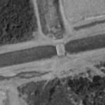
Here is the picture , 4 miles east of hi way 95 N of Yuma, Az stage stop site is just below the center and to the right, light colored circle.
 

Attachments

  • Butterfieldstage.jpg
    Butterfieldstage.jpg
    6.4 KB · Views: 2,930

Desertdigger

Full Member
Jul 15, 2004
115
8
Wickenberg , AZ
Detector(s) used
CTX3030,Tesoro Lobo ST, Gold Bug ,Minelab probe
Primary Interest:
All Treasure Hunting
Woops! Sorry the preceding text did not make it to the post. This is a TerraServer picture centered on the Butterfield Trail road which is still in use, it runs from Hi way 95 north of Yuma, AZ to Wellton ,AZ and beyond to the east and to the west it crosses the Gila river and the colorado river into California and a lot of it is still locateable. If you go on the Butterfield trail road east off of 95 until you come to a concrete underpass under the RR and park in that area and search the North side of the road to the east you will find the foundations of the old station, I had a 160 acre placer claim there for several years and watched lots of metal detectors used in the area. it is in the North part of Section 14 Range 20 W, Township 8 S.
 

labato

Tenderfoot
May 29, 2005
6
5
hello,
Is there not a library in San francisco, CA that has all the Wells Fargo stageline maps station to station?
labato
 

Gork

Full Member
Dec 13, 2004
136
16
Here is the picture , 4 miles east of hi way 95 N of Yuma, Az stage stop site is just below the center and to the right, light colored circle.

The photo shown is not of a Butterfield Stage Station but it may have been a later stage station. The Butterfield Stage Stations in the area were up at Gila City and just across from present day Yuma. These two Butterfield stations were Snively's at Gila City and Jaeger's across the river. There are no existing ruins of a Butterfield station in Arizona except the ruins of the stone station at Dragoon Springs.
 

goldentruth

Hero Member
Nov 3, 2011
523
38
French Gulch, North Calif.
Detector(s) used
"WHITES" GOLDMASTER "GMT" & "TESORO GOLDEN SABRE II" with silent search.
Primary Interest:
Metal Detecting
My TH buddies need to find the routes of some of the old Wells Fargo stagecoach routes here in Arizona.

Any info on where to find exact routes would be very much appreciated.

Goldfinder
I know I'm not in Arizona but if you ever get to French Gulch, North California in Shasta City, check out our historic gold heists. In French Gulch we have has the famous "Black Bart", "Rattlesnake Dick" and the Wells Fargo "Ruggles Brothers" stage Coach Hold up in the city of Old Shasta of a chest of Bank's Gold. Good hunting & luck if you come our way.
 

Frankn

Gold Member
Mar 21, 2010
8,711
2,989
Maryland
Detector(s) used
XLT , surfmaster PI , HAYS 2Box , VIBRA-TECTOR
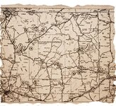
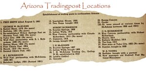
Arizona 700 map.jpg Arizona Tradingpost List 700.jpg Horney toad and ant-AZ.jpg
Here's the AZ trading post list from my files. I ran it at 700pics, but it still came out small, sorry. Frank
If you click on the image, it gets bigger and you can click one more time. If you aren AZ, you got a hunt site.
 

Last edited:

Frankn

Gold Member
Mar 21, 2010
8,711
2,989
Maryland
Detector(s) used
XLT , surfmaster PI , HAYS 2Box , VIBRA-TECTOR
Come on, I gave you the sites of the tradingpost, some of which were used as stage stops. Just click on the image for enlargement. They are the full 700 dpi allowed. You can read the listing by clicking next. Post if you found anything, unless it's a chest of gold coins, if that, forget about it. lol Horney toad and ant-AZ.jpg
 

Frankn

Gold Member
Mar 21, 2010
8,711
2,989
Maryland
Detector(s) used
XLT , surfmaster PI , HAYS 2Box , VIBRA-TECTOR
Hay you guys!!!!!! I through out some good research so you could have some sites, now how about some feedback!!!!!!!!!!!!!!! hand print-2_edited-6.jpg
 

boogeyman

Gold Member
Jun 6, 2006
5,016
4,399
Out in the hills near wherendaheckarwe
Detector(s) used
WHITES, MINELAB, Garrett
Primary Interest:
All Treasure Hunting
My TH buddies need to find the routes of some of the old Wells Fargo stagecoach routes here in Arizona.

Any info on where to find exact routes would be very much appreciated.

Goldfinder
The library downtown (Phoenix) has some good info. Ask the reference librarian, and they'll get you pointed in a good direction.
 

Tanneyhill

Full Member
Mar 5, 2023
102
117
I know I'm not in Arizona but if you ever get to French Gulch, North California in Shasta City, check out our historic gold heists. In French Gulch we have has the famous "Black Bart", "Rattlesnake Dick" and the Wells Fargo "Ruggles Brothers" stage Coach Hold up in the city of Old Shasta of a chest of Bank's Gold. Good hunting & luck if you come our way.
Goldentruth, you make any attempts to locate these caches? I have been reading about all the heists, lost mines, and other forms of lost loot in California's gold rush days. I am moving to California by December, 2023 and am fascinated to begin the adventure of searching for caches. Is the south west part of Mt Shasta a safe place to be out there searching? I know the Keswich area can be a little shady with drug related crimes but I haven't spent much time there so not sure what to expect. Appreciate any thoughts you may have of the region. Ty.
 

unclemac

Gold Member
Oct 12, 2011
7,026
6,926
Primary Interest:
Beach & Shallow Water Hunting
I don't know about AZ but I have found them in NV by using google earth and a little local history. Figure that a road/track existed between localities that existed in say 1870-80, find the present day hi-way and look from side to side. Many modern day roads tend to follow older existing roads but straightened out. You can often zero in on a left over desert track.
 

Top Member Reactions

Users who are viewing this thread

Latest Discussions

Top