Basic signs and symbols you have found

Texas Jay

Bronze Member
Feb 11, 2006
1,147
1,355
Brownwood, Texas
Detector(s) used
Garrett AT Pro, Garrett Scorpion Gold Stinger, Garrett Ace 350, Garrett Ace 250, vintage D-Tex SK 70, Tesoro Mojave, Dowsing Rods
Primary Interest:
All Treasure Hunting
I'd never noticed the shadow face before you guys noticed it. So cool! I have a lot to learn about deciphering signs and symbols so I really appreciate your comments based on your experience. The bear is on a rock on the face of a cliff and, to the left side of it (west) only a few yards away, we found these three horseshoes (muleshoes?) on a large slab of the same type of rock that is laying flat on the ground. The rock on this site is very hard and not easy to carve in so these more intricate carvings probably took several hours and the right equipment to create. The bronze token is one of my sobriety chips and is about the size of a silver dollar. I placed it there for size comparison purposes. I also outlined the carvings that I could clearly make out in white chalk.
~Texas Jay
 

Attachments

  • horseshoes-reduced1.jpg
    horseshoes-reduced1.jpg
    81.1 KB · Views: 1,050

Shortstack

Silver Member
Jan 22, 2007
4,305
416
Detector(s) used
Tesoro Bandido II and DeLeon. also a Detector Pro Headhunter Diver, and a Garrett BFO called The Hunter & a Garrett Ace 250.
Primary Interest:
All Treasure Hunting
OK, TJ, here's the obvious (to me)
 

Attachments

  • horseshoes-reduced1 Merged Merged.jpg
    horseshoes-reduced1 Merged Merged.jpg
    98.7 KB · Views: 1,018

Texas Jay

Bronze Member
Feb 11, 2006
1,147
1,355
Brownwood, Texas
Detector(s) used
Garrett AT Pro, Garrett Scorpion Gold Stinger, Garrett Ace 350, Garrett Ace 250, vintage D-Tex SK 70, Tesoro Mojave, Dowsing Rods
Primary Interest:
All Treasure Hunting
Yes, Shortstack, that is what they looked like to me too. Sure wish I knew what those straight lines meant and also what the "M" represents. ??? It is probable that the Spanish used this site as a landmark as others, including the KGC, did a few hundred years later.
~Texas Jay
 

Shortstack

Silver Member
Jan 22, 2007
4,305
416
Detector(s) used
Tesoro Bandido II and DeLeon. also a Detector Pro Headhunter Diver, and a Garrett BFO called The Hunter & a Garrett Ace 250.
Primary Interest:
All Treasure Hunting
TJ, I can only quote from Kenworthy's book.

A short "dash" has numerous meanings, depending how and where it is used.

---if it is connected to a symbol, it probably is a "pull" sign.

---It may be used just to separate one instruction / message from another.

---It may say: - to the - (next symbol), or may say: "subtract".


Muleshoes are map / trail symbols for the trail, however, these are used as both in and out trail markers, and were used more on Mexican maps than Spanish. The "closed" end of the shoe is the direction to travel. Often, in the field, along the trail will be the carving of 2 "shoes" with open ends facing one another. This simply says; "This is the trail both in and out".

More info on the "muleshoe" figure:
This is the classic "tunnel" symbol. The direction it angles is usually the compass direction of the mine entrance. Frequently this sign will adjoin a mine symbol (a circle in a circle). Many times it will be off to itself or at the top of the map, again, just indicating access to the mine will be via a tunnel. It's a good clue, it will show you which slope or mountain side to search.

Remember that "S" I circled on your first "bear" carving photo? Well, according to Kenworth:
The letter "S" in and of itself represents the Spanish word "Superior". This letter is found both on maps and on the trails to treasure, but always in conjunction with other symbols or markers. It simply means, on maps, that this is the "Best" way to reach your goal, but that there are other ways available. Often a dot will follow the "S". This means it is superior because water--or more water is available.
So, instead of it meaning "south" as I first thought, it apparently means "Superior". It is used in conjunction with other symbols on that caving, so I wonder if it might mean, " a large (superior) treasure". And that "5" means silver mine, bars, or coins-----or all of those.
The letter "S" with bar serifs, is the directional letter meaning "south".


NOTE!!!!!! I just found in Kenworthy's book that the letter I thought was an "M" is not that, but it is a "W" and gives direction (west). A "hard" or straight lined and pointed "W" is always, and only, a "W".
I'll change the tagged info on the photo above.
 

Shortstack

Silver Member
Jan 22, 2007
4,305
416
Detector(s) used
Tesoro Bandido II and DeLeon. also a Detector Pro Headhunter Diver, and a Garrett BFO called The Hunter & a Garrett Ace 250.
Primary Interest:
All Treasure Hunting
hadji009 said:
M COULD ALSO MEAN OWL, OWL MEANS TREASURE ROOM.

:dontknow: It might. I am no expert and am only quoting from Kenworthy's book about the letter "W". He does mention that the Spanish and, later, the Mexicans, used Roman Numerals on their maps and trail markers and the letter "M" is one of them.
 

OP
OP
Old Dog

Old Dog

Gold Member
May 22, 2007
5,860
397
Western Colorado
dsty said:
My Thoughts about the "W" is that they used letters of the alphabet to convey or to continue their messages, total of the measurements used by the Tailor for the King in 1400's Height of the King = 5 ft 7 in--Codo = 16.5 in---Palmo + 8. 25 in Total = 91.75 inches or 233 CM this can be used as a depth indicator 7 ft 7 inches or as a distance indicator 233 paces-- or X 10 =2330 vara X 33 = 76890 inches --then take a mile or 5280 X 12 = 63360 inches per mile--- Divide 76890 by 63360 = 1.2135 or 1/2 of a league for distance AND it can be used as a compass degree AND it can be use as All three, It can represent two each 33 degree turns it can be used as two canyons, two mountains-- the list continues for the 23 rd letter of the alphabet, thanks for the look

Thanks Buddy.
 

Clay Lindsey

Full Member
Jan 8, 2010
151
6
Sierra Vista, AZ
Wow! Step away for a second and all types of good advice and beautiful pics come out of the woodwork....

Ok. Goin on vacation... Can't wait to get back and learn. See you soon....

Clay
 

Texas Jay

Bronze Member
Feb 11, 2006
1,147
1,355
Brownwood, Texas
Detector(s) used
Garrett AT Pro, Garrett Scorpion Gold Stinger, Garrett Ace 350, Garrett Ace 250, vintage D-Tex SK 70, Tesoro Mojave, Dowsing Rods
Primary Interest:
All Treasure Hunting
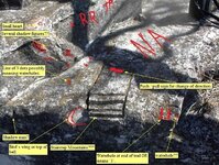
Thanks, guys, for all of the fascinating replies and information. I will be saving them all to a notepad and print them off so that my partner and I can thoroughly review them before we make another trip to the area. Our next trip will have to wait until next winter as the place is crawling with rattlesnakes and copperheads during other times of the year. It is on private property that is well-secured and the snakes will be coming out in the next few weeks. I'm going to post the third photograph of another major sign from this site to this message. A little more background is necessary here. The bear, muleshoes, and staircase carvings are all on the same cliff area and are within ten yards of each other. The muleshoes are to the west of the bear and the staircase is to the north of the muleshoes on the same ledge of surface rock as the shoes are on. You will note my camera and equipment bag sitting at the top corner of the photo. If you were look to the left of the bag, you would first see the muleshoes carving and then up on the cliff face, further to the left (east) you would see the bear carving. Now, for the staircase photo. In the center of the picture, above the stairs, is a horizontal notch (dash mark) that is about an inch deep. To the right of the stairs are two "l" marks with a "period" or dot between them. Although I've looked at this carving many times on previous visits there, I only just now noticed what looks like another muleshoe adjoining the bottom left of the stairs! I don't remember EVER seeing that before and cannot understand why I only just now noticed it from the photo. Surely, I would have noted it before I photographed it but I didn't. All I can say is that maybe it only shows up clearly in the photo and wasn't noticeable to me or my partner is because the angle of the camera and the sunlight was hitting it just right. I really don't know how else to explain it. I do know that the letters one other sign rock, from another site, was only visible when the sun was in the perfect angle although we had visited that rock on several occasions and could not read the markings on it. This staircase is facing north-south with the stairways facing north and the notch on the south side.
~Texas Jay
 

Attachments

  • staircarvingreduced.jpg
    staircarvingreduced.jpg
    89.8 KB · Views: 1,011
  • staircarvingreduced.jpg
    staircarvingreduced.jpg
    89.8 KB · Views: 1,021
OP
OP
Old Dog

Old Dog

Gold Member
May 22, 2007
5,860
397
Western Colorado
Jay,
Just above the second I mark and just next to the second I mark are two more marks that show up cleanly.
A cross bar and another dot of sorts.
And what are these in the center? Scratches?
 

Attachments

  • staircarvingreduced.jpg
    staircarvingreduced.jpg
    85.3 KB · Views: 993

Shortstack

Silver Member
Jan 22, 2007
4,305
416
Detector(s) used
Tesoro Bandido II and DeLeon. also a Detector Pro Headhunter Diver, and a Garrett BFO called The Hunter & a Garrett Ace 250.
Primary Interest:
All Treasure Hunting
TJ,
This is a "busy" site. Here's my markup. Question: Are there any mountains or hills in the area referred to as the "stairstep hills" or "stairstep mountains" like they have in eastern OK? The heights and widths of the steps are not uniform. I wonder if there is a code for distances and depths hidden there.

staircarvingreduced Merged.jpg
 

Texas Jay

Bronze Member
Feb 11, 2006
1,147
1,355
Brownwood, Texas
Detector(s) used
Garrett AT Pro, Garrett Scorpion Gold Stinger, Garrett Ace 350, Garrett Ace 250, vintage D-Tex SK 70, Tesoro Mojave, Dowsing Rods
Primary Interest:
All Treasure Hunting
Clay, I suppose the "staircase" could represent a book. That possibility had crossed my mind but I figured it was probably stairs. Thom, the area is full of latter-day grafitti, names, dates, and initials. Most of that was put there in the late 1800s and very early 1900s when it was a popular gathering place. The large initials above the staircase are, I believe, "NA" but there are hundreds of other carvings around the cliff face and so I concentrated on the most intricate ones and those that seemed to be of historical importance such as names of people who played a part in the area's history. I think the "scratches" are either natural or possibly the result of this large flat rock being chiselled out of the main block for the purpose of carving the intricate muleshoes and stairs. I say this because when you look at the main rock in the upper left side, it looks like it may have been carved out to make for a flat surface to carve on.
~Texas Jay
 

Texas Jay

Bronze Member
Feb 11, 2006
1,147
1,355
Brownwood, Texas
Detector(s) used
Garrett AT Pro, Garrett Scorpion Gold Stinger, Garrett Ace 350, Garrett Ace 250, vintage D-Tex SK 70, Tesoro Mojave, Dowsing Rods
Primary Interest:
All Treasure Hunting
Shortstack said:
TJ,
This is a "busy" site. Here's my mark-up. Question: Are there any mountains or hills in the area referred to as the "stairstep hills" or "stairstep mountains" like they have in eastern OK?

There are several creeks in the area where the carvings are. Your mark-up seems to emphasize that what I originally thought was another muleshoe may have actually been a "crescent" which was one of the KGC's primary symbols. I'll have to take a much closer look at all of these features when I next visit the site. No, there are no mountains or hills in that county or adjoining counties that are referred to as "stairstep" at least that I am aware of. But it is sure conceivable that, at the time when the carvings were made, the mountains and hills in the area had not yet been named. I'll look into this possibility also in upcoming days to see if there are any such historical references for the area. There are many historical references to Spanish mining and other operations in that area of Texas, within 100 miles or so. Probably the most well-known are the many accounts of what is known as "Jim Bowie's Lost Mine" and the Spanish presidio at Los Almagres. J. Frank Dobie in "Coronado's Children" first educated me about the Spanish exploration of this area.
~Texas Jay
 

OP
OP
Old Dog

Old Dog

Gold Member
May 22, 2007
5,860
397
Western Colorado
Be careful how much trust you put in books Jay,
I have discovered over the years that a lot of "literary liscence" has been used when writing about American History.
 

Texas Jay

Bronze Member
Feb 11, 2006
1,147
1,355
Brownwood, Texas
Detector(s) used
Garrett AT Pro, Garrett Scorpion Gold Stinger, Garrett Ace 350, Garrett Ace 250, vintage D-Tex SK 70, Tesoro Mojave, Dowsing Rods
Primary Interest:
All Treasure Hunting
Old Dog said:
Be careful how much trust you put in books Jay,
I have discovered over the years that a lot of "literary liscence" has been used when writing about American History.

Hi Thom. That is certainly one lesson that I've learned very well in the past 5 years. :read2:
~Texas Jay
 

Shortstack

Silver Member
Jan 22, 2007
4,305
416
Detector(s) used
Tesoro Bandido II and DeLeon. also a Detector Pro Headhunter Diver, and a Garrett BFO called The Hunter & a Garrett Ace 250.
Primary Interest:
All Treasure Hunting
It is well known that Mr. Dobie took a whoooooole lot of poetic license when he wrote that book. It turned out that it is great for entertainment, but NOT for literal treasure hunting history.
 

OP
OP
Old Dog

Old Dog

Gold Member
May 22, 2007
5,860
397
Western Colorado
And others.

One practical example is the textbook used to teach Western Colorado History.
It states that Fr Escalante was the first Spaniard in Western Colorado.
Escalante came in 1776 looking for a trail to the west coast.

That trail had been used as an alternative trail as a bypass to Santa Fe for more than 100 years by Spanish miners.
The reason Escalante never found it was because he crossed the Gunnisson River. If he had just followed the River he would have found the trail.
His protoge, Fr Dominguez did exactly the same thing.

My partner and I spent 23 years chasing that trail (backtrailing) from Flagstaff AZ. to where it crosses the Gunnisson.
Just for the record the bridge on Colo 141 at Whitewater is exactly where this trail crosses the River.
The trail follows 141 for a long way then turns west and south again until it reaches Flagstaff.
It then continues west and south again until it reaches Baja.
An interesting turn for the books.

Along his journey Escalante trailed up through an established Spanish settlement that he found abandoned to his dismay (he wrote) that was also in western colorado. All the abutments, roads and fortifications are still here.
Historians refuse to acknowledge these things.

Oh well.
Sorry about the short rant.
Knowing gives us an edge over those who rely on books
 

Shortstack

Silver Member
Jan 22, 2007
4,305
416
Detector(s) used
Tesoro Bandido II and DeLeon. also a Detector Pro Headhunter Diver, and a Garrett BFO called The Hunter & a Garrett Ace 250.
Primary Interest:
All Treasure Hunting
O.D.
No rant, just truth. :thumbsup:

One of the best western historians / writers I've found is Glenn Shirley. He is / was a regular writer for Old West magazine and published many books on western history. He was possibly the first historian to debunk the "Belle Starr, Bandit Queen" idea. He showed that it was bs that BS was a gang leader and big, bad bandit. She was a camp follower who got "turned on" by bad boys. She was a Motorcycle Mama before motorcycles were invented. :laughing7: The dime novel writers "invented her" just like they did Wyatt Earp and Buffalo Bill Cody.
 

Top Member Reactions

Users who are viewing this thread

Latest Discussions

Top