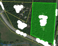
Did some land surveying at moms today and was shocked

OP
OP
civil_war22

civil_war22

Relic Recovery Specialist
Dec 5, 2008
3,215
2,810
NW Arkansas
🥇 Banner finds
1
🏆 Honorable Mentions:
1
Detector(s) used
Fisher F75 SE/LTD2, minelab Etrac, whites classic id, spectrum xlt, fisher f7, fisher 1266, king of all Tesoro Cibola, Tesoro Vaquero, Fisher 1280-X, minelab equinox, Fisher F75+ Garrett AT MAX
Primary Interest:
Relic Hunting
give em an inch they will take a mile or 3. I would be polite about it but dont let it continue

They weren’t home today, but I got the survey map out. Moms owns approximately 120’ more than she thought she did at the bottom of the hill, and you can see where they have pushed a rock up, to make it look like a corner marker, and then put a set of 3 insulators in a small cedar tree in a corner. When I
did the measurements, I not only used a long 100’ tape measure, but also a can of pink surveying paint, to spray. I walked up on the part of the mountainside that they thought was theirs all along, and you can follow a track from the bottom to the top from the surveyors cutting down cane poles, to measure up the hill side, then you can see where they scrambled up to the top, and have used a a old corner post directly in line with the survey mark below, to use
as a guide for up top. It was a original corner post, that had wire around the bottom of it. I measured from there to where they had the edge of their fence at today, and it was over the line more than 50’. I’m getting the new survey out tonight, setting down with a pen, and paper, and writing out their measurements, and the areas they used for references. I can already tell this is going to be one of those situations where they’ll either be nice about it once I give them the attorney spill, or they will feel like my mom is going back on her word, and if they say that I’m going to say exactly what you said, and that you took the kindness of one person, and decided to not only overstep on one spot, but an entire 10 acres of wooded land, and some of which you cut down timber that didn’t belong to you.
 

kingskid1611

Gold Member
Feb 23, 2015
8,135
6,683
Oklahoma
Primary Interest:
All Treasure Hunting
Reminds me of a time about 25yrs ago when my parents got a new neighbor. They came home one Sunday and he was blocking their driveway. He proceeded to tell them that he was looking at the deed and he believes he owns half of their driveway. I have never seen my dad get so mad and he was the pastor of the church.:laughing7: Anyway long story short they had it surveyed and found out we owned about ten feet on his side...and that pissed him off and he sold the place and moved.
 

OP
OP
civil_war22

civil_war22

Relic Recovery Specialist
Dec 5, 2008
3,215
2,810
NW Arkansas
🥇 Banner finds
1
🏆 Honorable Mentions:
1
Detector(s) used
Fisher F75 SE/LTD2, minelab Etrac, whites classic id, spectrum xlt, fisher f7, fisher 1266, king of all Tesoro Cibola, Tesoro Vaquero, Fisher 1280-X, minelab equinox, Fisher F75+ Garrett AT MAX
Primary Interest:
Relic Hunting
Reminds me of a time about 25yrs ago when my parents got a new neighbor. They came home one Sunday and he was blocking their driveway. He proceeded to tell them that he was looking at the deed and he believes he owns half of their driveway. I have never seen my dad get so mad and he was the pastor of the church.:laughing7: Anyway long story short they had it surveyed and found out we owned about ten feet on his side...and that pissed him off and he sold the place and moved.

That’s what’s going to happen here. For many years the old man( landowners dad) was a pain in the butt, he would frequently act as if he owned more than he did, even go as far as letting his dogs loose when we were walking along the creek where the spring is, and they’d come over growling at us. His daughter I believe didn’t fall far from the stupid tree because it would take a moron to look at a piece of property, who’s seen it hundreds of times over the years of her life, know the boundary lines, and then exceed them by not just a couple of feet, but at its farthest at 80’. I’ve already found the marker down at the bottom of the hill today, traced a line up the hill with pink surveyors paint in a can, and will go back tomorrow with the survey, and finely nit pick it, climb over their side, and put down paint on the ground where our fence line is.
 

releventchair

Gold Member
May 9, 2012
22,560
71,680
Primary Interest:
Other
They weren’t home today, but I got the survey map out. Moms owns approximately 120’ more than she thought she did at the bottom of the hill, and you can see where they have pushed a rock up, to make it look like a corner marker, and then put a set of 3 insulators in a small cedar tree in a corner. When I
did the measurements, I not only used a long 100’ tape measure, but also a can of pink surveying paint, to spray. I walked up on the part of the mountainside that they thought was theirs all along, and you can follow a track from the bottom to the top from the surveyors cutting down cane poles, to measure up the hill side, then you can see where they scrambled up to the top, and have used a a old corner post directly in line with the survey mark below, to use
as a guide for up top. It was a original corner post, that had wire around the bottom of it. I measured from there to where they had the edge of their fence at today, and it was over the line more than 50’. I’m getting the new survey out tonight, setting down with a pen, and paper, and writing out their measurements, and the areas they used for references. I can already tell this is going to be one of those situations where they’ll either be nice about it once I give them the attorney spill, or they will feel like my mom is going back on her word, and if they say that I’m going to say exactly what you said, and that you took the kindness of one person, and decided to not only overstep on one spot, but an entire 10 acres of wooded land, and some of which you cut down timber that didn’t belong to you.

My area in the midwest , timber theft used to run 3 times the value in restitution. Not sure where it is today , but it sure ain't worth getting caught...
 

OP
OP
civil_war22

civil_war22

Relic Recovery Specialist
Dec 5, 2008
3,215
2,810
NW Arkansas
🥇 Banner finds
1
🏆 Honorable Mentions:
1
Detector(s) used
Fisher F75 SE/LTD2, minelab Etrac, whites classic id, spectrum xlt, fisher f7, fisher 1266, king of all Tesoro Cibola, Tesoro Vaquero, Fisher 1280-X, minelab equinox, Fisher F75+ Garrett AT MAX
Primary Interest:
Relic Hunting
My area in the midwest , timber theft used to run 3 times the value in restitution. Not sure where it is today , but it sure ain't worth getting caught...

Yep. I haven’t been able to see how many trees they’ve cut down, but I know there were several large oaks over there that were dead, and some other larger trees. They’ve had a few bonfires, and wondered where they got all the wood. Now I know
 

IMAUDIGGER

Silver Member
Mar 16, 2016
3,400
5,194
Primary Interest:
All Treasure Hunting
Just remember that the cut line may be a random traverse line from which offsets were pulled once they tied into enough corners to resolve the property lines.

Pretty common practice in wooded areas even today.

If you can't see between corners (even then your taking a big risk)...I'd probably be calling the survey outfit to stake some intermediate points.

Land surveying is not quite as simple as most people take it to be. Plenty of people get into trouble because of that. I have witnessed that first hand many times. First thing a land owner does when you get there to survey their property is tell you where the property lines are.

You listen because there might be some critical information passed on, but pretty much take it with a big old lump of salt.
Handheld GPS, GIS aerial maps, and tax maps seem to really convince people they are right. I can't tell you how many times I've been told I have a recent survey..that they have "pulled some distances" and then hand you a tax assessor map.

It's common ignorance in its basic definition.
 

delnorter

Hero Member
Oct 28, 2008
908
2,302
Northern California
Primary Interest:
All Treasure Hunting
Take what IMAUDIGGER said above to heart. Get a licensed land surveyor out there and have the boundary between owners set properly. It’s really the only way to begin to resolve this.

Mike
 

trdking

Gold Member
Feb 28, 2015
5,139
7,923
Fullerton CA
Detector(s) used
Minelab CTX 3030
AT Pro
Primary Interest:
All Treasure Hunting
Nip it in the bud now, lest it becomes a hatfield McCoy issue
 

OP
OP
civil_war22

civil_war22

Relic Recovery Specialist
Dec 5, 2008
3,215
2,810
NW Arkansas
🥇 Banner finds
1
🏆 Honorable Mentions:
1
Detector(s) used
Fisher F75 SE/LTD2, minelab Etrac, whites classic id, spectrum xlt, fisher f7, fisher 1266, king of all Tesoro Cibola, Tesoro Vaquero, Fisher 1280-X, minelab equinox, Fisher F75+ Garrett AT MAX
Primary Interest:
Relic Hunting
OP
OP
civil_war22

civil_war22

Relic Recovery Specialist
Dec 5, 2008
3,215
2,810
NW Arkansas
🥇 Banner finds
1
🏆 Honorable Mentions:
1
Detector(s) used
Fisher F75 SE/LTD2, minelab Etrac, whites classic id, spectrum xlt, fisher f7, fisher 1266, king of all Tesoro Cibola, Tesoro Vaquero, Fisher 1280-X, minelab equinox, Fisher F75+ Garrett AT MAX
Primary Interest:
Relic Hunting
land encroached .png Screenshot (6).png
Just remember that the cut line may be a random traverse line from which offsets were pulled once they tied into enough corners to resolve the property lines.

Pretty common practice in wooded areas even today.

If you can't see between corners (even then your taking a big risk)...I'd probably be calling the survey outfit to stake some intermediate points.

Land surveying is not quite as simple as most people take it to be. Plenty of people get into trouble because of that. I have witnessed that first hand many times. First thing a land owner does when you get there to survey their property is tell you where the property lines are.

You listen because there might be some critical information passed on, but pretty much take it with a big old lump of salt.
Handheld GPS, GIS aerial maps, and tax maps seem to really convince people they are right. I can't tell you how many times I've been told I have a recent survey..that they have "pulled some distances" and then hand you a tax assessor map.

It's common ignorance in its basic definition.

Here’s where I stand. I have walked these boundary lines many times, I’ve even walked it with the surveyor(family friend), and have done plenty of land surveying, grade measurements, digital surveying, and even 3D mapped locations. It’s all basic trigonometry. I’ve got the original, and the past survey(2018), here in my hand. They’re not the type of folks to freak out over a little bit of land, because they know they took a little too much of a bite off my moms land ie: more than they were told they could use.

I have several case laws, just in our state, I’ve got the backing of a attorney, and if need be the guys with the survey company will happily come back, and point them(neighbors) in the right direction. The only reason I was doing this personally was because it would resolve the issue of getting all legal parties involved which causes trust issues between neighbors. I’ve helped them plenty of times wrangle their horses once they’ve escaped, hell I’ve even walked one through the pitch black of darkness down the highway because they didn’t have a proper fence up at the time.

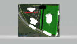
The whole fencing situation isn’t them “staking” their claim, it’s they want to keep in a outlandish number of horses on less than a 6 acre tract of land. I’m going to take a screen shot of the assessors website showing the gps coordinates that were entered in from the last survey done, showing y’all what I mean on just a smaller scale, without the exact measurements. Ours is highlighted green, theirs is Sat view, the black line is where they’ve staked out for horses, the square at the back is where they overshot their own side, as well as came over further on us(area where they cut our trees down, area of spring they dammed up, and area they added a 2nd fence in, and the little brown circle is the hay bale smack in the middle of the creek.)

**Illustration purposes only, not accurately measured to show extent of land being encroached on, very close to same proximity, as the road you can see coming up to house is next to black line which is their 2 strand nylon fence**
 

Last edited:

Top Member Reactions

Users who are viewing this thread

Top