Dr. Thorne's Gold

robertk

Bronze Member
May 16, 2023
1,990
9,237
Missouri
Detector(s) used
XP Deus II
White's Spectra v3i
Garrett Ultra GTA 1000
Whites Coinmaster
Primary Interest:
All Treasure Hunting
As is the case of many mining towns, few remember or understand just why most of these places are on the map. Telluride, named for the type of gold ore found there during the heyday of mining, is no exception.
When I was last in Telluride, I was told that the town name was a shortened version of "To Hell You Ride", because it was apparently a wild and somewhat inhospitable destination back in the day. Nothing to do with what was mined there.
 

Clay Diggins

Silver Member
Nov 14, 2010
4,890
14,265
The Great Southwest
Primary Interest:
Prospecting
hello Bookaroo

As always excellent posts by all concerned. I am enjoying this thread.

I gather your referring to Planchas de plata Sonora

While it was true most silver today in Arizona is by product of of copper mining smelting and gold and lead or composite mix of metals. Today native silver was rare. But parts of Southern Arizona in the very early days had quartz veins in almost pure silver. Native silver is almost pure. Yet please note definition of Arizona covered parts of Northern Sonora back then.

It is to see how such stories of discoveries evolve over time with each person adding some thing new. However I had no doubt Arizona is full of epithrermal vents with weather quartz some barren some with gold, some with pyrites and some with Silver.
Is there any rich out cropping to be found? It presumptuous to discount anything. Regardless the old time mining as the old west is dead. Because it comes down economies of scale.

As you all esteemed people now mining camps mines come and go? There ara thousands of broken dreams of shafts and pits across America and in fact around the world. The come and go but the legend lives on.

I have shares in company called Alien metals that own Elizabeth hill mine in western Australia Take a look at this baby take from a mine 144 kilos. That was one of many large pieces. ( That was from mine that was deemed not profitable and technically abandoned for 20 years. Until prices rose to make mining profitable.

View attachment 2099603

View attachment 2099605

The point I am trying to make is it is easy as this original story of discovery can change over time in each retelling. For me totally fascinating such stories take on life of their own. ( Dr throne story is classic example. )

I love the fire side stories and legends.( It would be a poor world if we did not have such legends ) But we have to take them with grain of salt. Yet be aware not to go to extreme of the other end of scale either.

Crow
Nice piece of calcite. Should bring a fair price in the collector market. Sadly these larger pieces often have trouble finding a home because of their size and care requirements. Most museums can't afford them and the modern collector market is more geared towards small specimens now.

A lot of closed mines still have good ore in them. They should remain available for development when humans need the resources but in this country they are attempting to fill and close older mines. Not very perceptive or considerate of our future needs but it's often seen as a solution to a problem that only exist in the media.

When you find one of these rich silver carbonate veins exposed on the surface you might lend some credence to the native silver claims here. Considering the nature of Calcite when exposed to the elements that will be a snipe hunt. :thumbsup:

I know of a place in Southern Arizona where you can pick up almost pure silver right from the surface. That silver is spill from a mining railway that was taking the silver ore to a nearby smelter.

I managed a ranch in the Dragoons where the main house was built on top of a rich silver ledge. Of course silver minerals can be tough to extract from native ores and this deposit was no exception. The owner had no interest in mining the silver. Despite my warnings to the ranch owner to secure his mineral rights a few years ago a large mining company moved in and claimed the mineral deposit under the house.

The fact is that due to the nature of silver ore it would be an exceedingly rare occurrence for free silver to be found on the surface in any usable quantity. I know some here believe in silver placers and silver nuggets but that's not a rational possibility. Silver nuggets are extremely rare and usually only found just downstream from a very rich exposed hardrock silver deposit. The reason why silver nuggets are really really rare and gold nuggets are not is because silver is eroded in the acid water and atmosphere found on the surface. Acid water and air break down the silver into very small, sometimes molecular, pieces rather quickly. Gold does not react to environmental acid so gold nuggets remain intact for the most part.

Treasure Hill in Nevada had native Silver Chloride exposures when discovered. Luckily magic was involved because the tale told to this day was the miners chopped out chunks of the Silver Chloride with their axes and melted it into pure silver over their campfires in their cooking pans (2,817 degrees F to purify Silver Chloride- Cast iron melts at 2,200 degrees F)! :laughing7:

There are many tall tales in mining. It gets lonely and boring out there without any TV, movies, music or women so tall tales were the order of the day.
 

sdcfia

Silver Member
Sep 28, 2014
3,661
8,893
Primary Interest:
Other
That's hilarious. There was no Telluride ore or gold mined in Telluride Colorado. This gold did not come from Telluride. Typical bogus advertising and bad research from Heritage.

The Idarado is in an entirely different district in Ouray about an hours drive from Telluride. The Idarado was primarily a lead mine but it did produce some fine rich gold specimens. I have a few raw jewelry grade pieces in my collection.
Technically, nothing was mined in Telluride, but just a mile east of the town, in Pandora, was the Idarado's mill and west end of the mine's main haulage tunnel. The mine portal was on the Red Mountain side of the ridge, on Hwy 550, halfway between Ouray and Silverton. In '74, most all employees lived on the portal side. There was no reason to drive to Telluride, as even the mill workers rode the haulage tram 5 miles from the portal all the way through the mountain to Pandora. My drift (galena, sphalerite, chalcopyrite, and rich in argentite and native gold) daylighted at about 11,000 ft elevation, as I remember, and we could eat lunch overlooking Telluride.
 

Old Bookaroo

Silver Member
Dec 4, 2008
4,318
3,510
Speaking of Telluride CO -

"On the morning of June 24, 1889, Robert LeRoy Parker, who would soon become the notorious train and bank robber known by his alias Butch Cassidy, and his accomplice Matt Warner walked into the San Miguel Valley Bank, at the site of what is now the Mahr Building, at 129/131 W. Colorado Ave. Warner pulled the teller over his desk, threatening him with death as Parker filled a bag with cash, eventually calculated to be $20,750..."


Recent research leans toward Harvey "Kid Curry" Logan being the leader of the Wild Bunch, not Butch. Interestingly, several Wide World Magazine articles from 1910 - 1913 cite Logan as the boss of the outfit. The Sundance Kid doesn't get much play.

Good luck to all,

The Old Bookaroo
 

sdcfia

Silver Member
Sep 28, 2014
3,661
8,893
Primary Interest:
Other
High grading still goes on even today but probably not as problematic as it was in the past. Truth be told many such items though various auction houses have dodgy provenance.

Crow
At the Idarado in 1974, the company was making so much money on the mere volume of base metal ore (lead, zinc, copper) coming out of that mountain that the gold and silver was just frosting on the cake. There was a tacit understanding between the management and the miners that high grading gold would be overlooked. No problem, boys - just keep the big tonnage coming. In fact, many of the older, more experienced stope miners would have quit and gone elsewhere otherwise. There were plenty of big highway tunnel jobs, etc available in CO in those days. Safer, well paying and easier.

Mineral specimens were also collected and taken out by the workers. Stunning optical quality quartz crystals in the vugs, galena crystals, peacock copper and more. Benjy's Rock Shop in Ouray had a steady supply coming in to sell to the tourists.
 

markmar

Silver Member
Oct 17, 2012
4,117
6,259
Primary Interest:
All Treasure Hunting
Now, if i would say ( always IMHO ) how Dr. Thorn's placer gold in that barren bedrock in a wash location is the same with the Lost Adams diggings spot, you wouldn't believe me. And how just about 1,5 mile south of that spot upstream, is the rich Antelope ( Sheep ) lost silver mine, which at the estimation of Edgar Cayce, was/is the richest silver mine in Arizona.
 

Last edited:

Old Bookaroo

Silver Member
Dec 4, 2008
4,318
3,510
E. O. Swarts is in from Spring creek, tributary of Gun creek, where he and
two partners have located a gold mine. The ledge is said to be four feet wide
and crops for 700 feet. Assay returns from a sample sent to El Paso showed
$240 gold. One of the partners claims to have received a description and map
of the Dr. Thorn mine from the doctor himself, and is confident that they have
discovered that lost bonanza. A shipment of ore is to be made through
Globe.
~Arizona Republican [Phoenix, Arizona] 28 August 1900 (VOL. XI NO. 101)


for FEBRUARY 15, 1925.

The Doctor Thorne Gold Mine

The story of many unsuccessful attempts on the part of Doctor Thorne to locate the rich gold deposits shown him by the Indians.​

By CHARLES M. CLARK, President, Arizona Pioneers' Association.

Along about 1870, in a skirmish with the Indians, a military surgeon named Thorne was captured by the hostiles, but as the chief of the hostile band had been seriously wounded in the fight, Dr. Thone's life was spared that he might care for the chief. Owing to the lack of the proper medicine, complications set in and it was several months before the chief was able to walk around. He was finally pronounced cured of his wounds and the attendant fever, and believing that the doctor had indeed saved his life, the chief was grateful and as time passed became very much attached to him. In the meantime, during the term [in] which the chief was disabled, the doctor had noticed several of the Indians in possession of extra large nuggets of gold and his curiosity and cupidity were aroused. After the chief had recovered, Thorne, presuming upon the friendliness of the chief, asked him where the Indians procured the nuggets. The chief replied that they got the yellow stones by breaking them from a band of white stone which lay in the mountains, but in spite of his friendly feeling for Dr. Thorne, he would not give further information. Thorne, however, did not despair and at subsequent intervals he made further interrogations, but to no avail. He was able, however, at a later date to save the life of the chief's son, who met with an accident while hunting, and it was necessary to amputate one hand. Following this service the chief told Thorne that if he would consent to be blindfolded during the daylight hours they would take him to see the band of white rock in which the little yellow rocks grew. At the time the band which had captured Thorne was camped at the junction of the White and Black Rivers, near where Fort Apache now stands. Thorne having consented to wear a blind during daylight, the chief told him they would start the following morning, which they did, mounting their horses at about daylight. The story of their trip as told by Thorne is that they traveled three days, his eyes being bandaged each morning and the bandage being removed when it became night. They went through mountains each day. On the afternoon of the third day the bandage slipped off his left eye. Taking advantage of this fact, he looked about for recognizable landmarks, he claimed that he saw the "Four Peaks", a very prominent landmark, visible for miles in almost any direction, and it was his belief that they lay to the west of the party, and that their course of travel was north and west. After a moment of concentration to fix the landmarks in his memory, he called the attention of the chief to the fact that the bandage had slipped off one of his eyes, and it was readjusted.

If, as Thorne thought, they were travelling west, they continued that course until night, when they made camp upon the bank of a flowing stream of considerable size. Just above them was a large beaver dam constructed across the stream bed between two abrupt banks of conglomerate. The bank on one side projected cliff like about 10 feet above the water, while the opposite bank, also of conglomerate, stood about four feet above the water. This beaver dam was about eight feet high and backed the water beyond his range of vision. The following morning he was again blindfolded and they crossed a mountain range requiring about two hours to reach the summit. After descending the far side of the mountain for about half an hour they again traveled over rising ground a short distance, when they again descended into a valley, where the blind was removed. He was led to the bank of a small flowing stream and directly across the stream from where he stood a strong white quartz ledge cropped above the hillside. As he remembered afterward, this ledge of quartz was about three feet in thickness and about in the center of it for about four or five inches in width was a vein of virgin gold, apparently solid and unbroken. The point where the quartz ledge cropped out close to the stream bank was well marked by a large sycamore tree alongside the quartz ledge and to the right of it. All this he noticed carefully, fully intending at some future time to return to the quartz ledge. As he stood on the bank of the small flowing stream Dr. Thorne looked toward the setting sun, the little stream at his feet, flowing from his left to right, or from north to south. All this he noted almost instantly, as he was permitted to stand looking at the quartz ledge. After a few minutes he was again blindfolded and the party mounted their horses, and traveled until night. When the blind was removed, Thorne found they were camped on the banks of a stream which could easily be the same stream upon which they camped the previous night, being about the same size, amount of water, etc. Following this, they again traveled three days, and when at night the blind was removed Thorne recognized their original camp at the junction of the White and Black Rivers.

Part II follows -
 

Old Bookaroo

Silver Member
Dec 4, 2008
4,318
3,510
Part II.

The foregoing is the story of the "Lost Doctor Thorne Mine," as recounted by old-timers who were in the country at the time when Thorne was feverishly combing the hills and valleys of Arizona in his futile search for a big white quartz ledge in the center of which was a vein of virgin gold four or five inches in thickness. I have heard the story on several occasions when sitting around the camp fire after supper. The pipes all going nicely and everyone rested from the day's travel, the questions of lost mines always comes up, and someone in the party was certain to mention the Thorne mine among other lost mines of Arizona.

I heard the story told by Charley Dupont (Charley, the Liar), which, while not exactly indisputable authority, yet it compared so exactly with the same story told me by Al Seiber, Doc O'Dougherty, John Boyd and Bill Hope, all of them old-timers and each of them an indefatigable prospector, that credence must be granted. With many others, some of whom were personally acquainted with the doctor, I fully believe Thorne thought he saw the big quartz ledge carrying the vein of virgin gold, as he described it. I believe that he thought he saw it, but I do not believe that he saw what he described. In the first place, during about 50 years of mountain experience, I never knew of nor ever heard of gold appearing in such shape and richness; it simply isn't done that way. In the second place, I found what I believe to be the Thorne mine years ago. As I remember, it was in 1878. Of this, more anon. A few months after their return to the camp at the junction of White and Black Rivers, Thorne induced the chief to release him and permit him to return to his own people. Making his way to Camp Goodwin, which at that time stood on what is now the Wightman ranch, south of the present town of Geronimo, Thorne resigned from the army, turned all his possessions into cash, and outfitted himself for a systematic search for the lost mine. After a number of months, finding himself about broke, he went to St. Louis, where he had numerous friends. To these friends he told the story of his captivity among the Apaches and the trip to the lost mine. The result was that his friends agreed to finance him for a further search for the mine. He came back to Arizona, made up a party strong enough to take care of themselves, and for over a year searched the mountains of northeastern Arizona, without results. His friends having lost confidence in his ability to find the mine, declined to finance him further, and his party was disbanded. He then went back home and induced his brother to furnish him means to continue his search. In this case also he exhausted the finances or the confidence of his backer and, financial support being withdrawn, he left Arizona a broken and disappointed man. Al Seiber told me Thorne was a d---- nuisance to the military. Seiber was chief of scouts for General George Crook, and said that Thorne persisted in showing up at the junction of White and Black Rivers every now and then to make a new start from that point in his search for the lost mine. The Apaches were particularly thick in that neighborhood, and on two occasions a skirmish party was sent out to cover Thone's party. Now, to analyze the Thorne story, taking the high points and comparing them with later knowledge of conditions:

1. The band which captured Thorne was camped at the junction of White and Black Rivers.

2. Thorne contended the course of travel was westerly.

3. Thorne thought he recognized the Four Peaks when the blindfold slipped off his eye on the afternoon of the third day.

4. The party camped on the evening of the third day's travel on the banks of a flowing stream of considerable size, near a beaver dam between conglomerate tanks.

5. The following day they traveled over a high mountain, and in the afternoon entered a small valley in which a small flowing stream ran from north to south.

6. In this valley he saw the big white quartz ledge running down the side of the hill on the west side of the stream or from west to east.

7. At the foot of this white quartz ledge, on the right hand side of it, at the stream hank, was a large sycamore tree.

So much for the Thorne story. In 1878 I was prospecting in the Tonto Basin country. My camp was at Green Valley, where the town of Payson now is. The nearest point for supplies was Fort McDowell, a military post about 35 miles east of Phoenix. The route from Green Valley to McDowell was down Tonto Creek to Reno Mountain, where, through a pass in the mountain, the government had built a wagon road. Following this road over Reno Pass, the route followed down the west side of the mountain to Sunflower Valley, thence widening through hills until McDowell was reached. Making this trip in the fall of 1878, I reached Sunflower Valley in the late afternoon and concluded to camp for the night. Next morning as I brought my saddle and pack horses into camp, I came down the bank of a small running stream flowing from the upper valley, north to the outlet of the valley, south. Across the stream I saw a strong white quartz ledge running down the hillside. I crossed the little stream to examine the ledge, and found that right down the center of the ledge was a streak of heavy cubical pyrites, yellow as gold. The little vein within the big ledge was plainly marked and fairly continuous. At the foot of this white quartz ledge near where it cut the bank of the stream, and on the north or right hand side of the white ledge, was the stump of a fair-sized sycamore which had been burned. There you are, at Dr. Thorne's mine, I believe, beyond question.

Taking the points of his story: From the junction of White and Black Rivers to Tonto Creek at a point near Reno Pass is about 90 miles, three days' ride. Tonto Creek, when I first saw it, was a strong-running stream, just above the Adams ranch. There were two or three big beaver dams between conglomerate banks, in which I used to go swimming with the Adams boys. The Adams ranch—afterwards known as the Watkins ranch—was about three miles from the site of the old fort at the foot of Reno Pass. The route followed by the Indians from the junction of [the] White and Black Rivers could have been down the west side of Salt River to a point near Gleason Flat, thence bearing northwest across the head of Cherry Creek, or Pleasant Valley, cutting over to Greenback, thence to the Tonto, at a point near the Adams ranch and beaver dams. From this camp over Reno pass to Sunflower Valley would be about half a day’s ride. This could have been cut a bit if the Indians went across north of the pass on Reno Mountain, which is probable.

The Four Peaks, one of the most prominent landmarks in Arizona, lie miles south of Reno Pass, in the same range. I have never had a doubt but that I had found the very ledge which Dr. Thorne spent so many weary months looking for.

Dave Balsz at one time had a bunch of cattle running in the Sunflower county, and in lower Sunflower, south and west of the big white quartz ledge. Balsz had a gold mine which was called "The Sunflower". This mine turned out some exceedingly rich gold ore, and I have often wondered if the Indians did not stop Thorne before reaching the real source of the gold nuggets he claimed to have seen in their camp at the junction of White and Black Rivers.

~ Arizona Mining Journal [Phoenix, Arizona] February 15, 1925 (VOL. VIII No. 18)

------- o0o -------

Charles McCoy Clark was born in Dubuque, IA on May 15, 1855. His family could trace its history back to one of the original passengers of the Mayflower to America. He came to Arizona as a telegraph operator in 1872. Later, Clark became involved with many pursuits including mining, merchant, postmaster, newspaper publisher in Globe, and developer of a Canyon Lake resort on the Apache Trail near Phoenix. In 1880 he married Dora E. Haugh of San Francisco. In 1882, he was appointed postmaster of Clifton and elected justice of the peace. Clark was elected president of the Arizona Pioneer Association in 1923 and wrote many articles concerning the early period of Arizona’s history. He worked and participated in the annual Pioneer’s Reunion sponsored by the Association until just before his death. Charles Clark died on September 2, 1937 in Prescott, AZ.

~ Arizona Historical Society website, retrieved 7/27/2023.

------- o0o -------

Notes – This account, combined with J.B. Hart’s version that was published thirty-five years before (I posted it here last week - #69), settles the legend for me.

I'm still looking for Milton Rose's account of the Lost Doctor Thorne - I believe it is in the Rainbow's End ms., if any TN members are willing to share it, I would certainly appreciate it!

Good luck to all,

The Old Bookaroo


markmar

Silver Member
Oct 17, 2012
4,117
6,259
Primary Interest:
All Treasure Hunting
E. O. Swarts is in from Spring creek, tributary of Gun creek, where he and
two partners have located a gold mine. The ledge is said to be four feet wide
and crops for 700 feet. Assay returns from a sample sent to El Paso showed
$240 gold. One of the partners claims to have received a description and map
of the Dr. Thorn mine from the doctor himself, and is confident that they have
discovered that lost bonanza. A shipment of ore is to be made through
Globe.
~Arizona Republican [Phoenix, Arizona] 28 August 1900 (VOL. XI NO. 101)


for FEBRUARY 15, 1925.

The Doctor Thorne Gold Mine

The story of many unsuccessful attempts on the part of Doctor Thorne to locate the rich gold deposits shown him by the Indians.​

By CHARLES M. CLARK, President, Arizona Pioneers' Association.

Along about 1870, in a skirmish with the Indians, a military surgeon named Thorne was captured by the hostiles, but as the chief of the hostile band had been seriously wounded in the fight, Dr. Thone's life was spared that he might care for the chief. Owing to the lack of the proper medicine, complications set in and it was several months before the chief was able to walk around. He was finally pronounced cured of his wounds and the attendant fever, and believing that the doctor had indeed saved his life, the chief was grateful and as time passed became very much attached to him. In the meantime, during the term [in] which the chief was disabled, the doctor had noticed several of the Indians in possession of extra large nuggets of gold and his curiosity and cupidity were aroused. After the chief had recovered, Thorne, presuming upon the friendliness of the chief, asked him where the Indians procured the nuggets. The chief replied that they got the yellow stones by breaking them from a band of white stone which lay in the mountains, but in spite of his friendly feeling for Dr. Thorne, he would not give further information. Thorne, however, did not despair and at subsequent intervals he made further interrogations, but to no avail. He was able, however, at a later date to save the life of the chief's son, who met with an accident while hunting, and it was necessary to amputate one hand. Following this service the chief told Thorne that if he would consent to be blindfolded during the daylight hours they would take him to see the band of white rock in which the little yellow rocks grew. At the time the band which had captured Thorne was camped at the junction of the White and Black Rivers, near where Fort Apache now stands. Thorne having consented to wear a blind during daylight, the chief told him they would start the following morning, which they did, mounting their horses at about daylight. The story of their trip as told by Thorne is that they traveled three days, his eyes being bandaged each morning and the bandage being removed when it became night. They went through mountains each day. On the afternoon of the third day the bandage slipped off his left eye. Taking advantage of this fact, he looked about for recognizable landmarks, he claimed that he saw the "Four Peaks", a very prominent landmark, visible for miles in almost any direction, and it was his belief that they lay to the west of the party, and that their course of travel was north and west. After a moment of concentration to fix the landmarks in his memory, he called the attention of the chief to the fact that the bandage had slipped off one of his eyes, and it was readjusted.

If, as Thorne thought, they were travelling west, they continued that course until night, when they made camp upon the bank of a flowing stream of considerable size. Just above them was a large beaver dam constructed across the stream bed between two abrupt banks of conglomerate. The bank on one side projected cliff like about 10 feet above the water, while the opposite bank, also of conglomerate, stood about four feet above the water. This beaver dam was about eight feet high and backed the water beyond his range of vision. The following morning he was again blindfolded and they crossed a mountain range requiring about two hours to reach the summit. After descending the far side of the mountain for about half an hour they again traveled over rising ground a short distance, when they again descended into a valley, where the blind was removed. He was led to the bank of a small flowing stream and directly across the stream from where he stood a strong white quartz ledge cropped above the hillside. As he remembered afterward, this ledge of quartz was about three feet in thickness and about in the center of it for about four or five inches in width was a vein of virgin gold, apparently solid and unbroken. The point where the quartz ledge cropped out close to the stream bank was well marked by a large sycamore tree alongside the quartz ledge and to the right of it. All this he noticed carefully, fully intending at some future time to return to the quartz ledge. As he stood on the bank of the small flowing stream Dr. Thorne looked toward the setting sun, the little stream at his feet, flowing from his left to right, or from north to south. All this he noted almost instantly, as he was permitted to stand looking at the quartz ledge. After a few minutes he was again blindfolded and the party mounted their horses, and traveled until night. When the blind was removed, Thorne found they were camped on the banks of a stream which could easily be the same stream upon which they camped the previous night, being about the same size, amount of water, etc. Following this, they again traveled three days, and when at night the blind was removed Thorne recognized their original camp at the junction of the White and Black Rivers.

Part II follows -
Good story Old Bookaroo. The only mistake in this story, is the stream DC. Thorne was sitting at the gold ledge spot, was running south to north. When someone is facing west ( setting sun ), the south is to the left and the north to the right. Small mistake but enough to mislead people who don't pay attention.
Now , the sycamore tree give a better description of the location, giving more options of where that spot could be: In a valley, along a little stream in a north trending canyon and close to a sycamore tree on the west bank.
Very nice!

PS
Question: could be a sycamore tree to be recognized as a " saddle tree " ?
 

Last edited:

sdcfia

Silver Member
Sep 28, 2014
3,661
8,893
Primary Interest:
Other

... I'm still looking for Milton Rose's account of the Lost Doctor Thorne - I believe it is in the Rainbow's End ms., if any TN members are willing to share it, I would certainly appreciate it!

Good luck to all,

The Old Bookaroo
I was given about 30 pages copied from an apparently lengthy unpublished manuscript (title unknown) written by Rose. There are a number of of handwritten notes in the margins and at the end of each chapter. My benefactor only sent me the Lost Adams chapters, but the paper also contains info on the Lost Thorne and the Lost Dutchman, as can be seen by the page headings shown below on the top part of the first page I received. I don't know if this is from "Rainbow's End" or not.

Rose.jpg

For what it's worth, a poster from another website who apparently read the manuscript offers this short synopsis of Rose's Thorne story. The Waltz allegation is interesting:

"-Rainbows
Milton F. Rose wrote a manuscript about the discovery of the first mine discovered or seen by a man named Doctor Thorne. The story goes that Thorne helped and healed many of the Indians in the area. To reward him, they blindfolded him and led him on horseback to a mine in the Suoerstitions. There they allowed him to take as much rich gold ore as he could carry. Later he tried to go back and find the place but never could. He nearly bankrupted himself trying to locate the spot. He ended up moving outside of Socorro, New Mexico and befriend a man name C. E, Cooley. He told Cooley the story and Cooley organized a party of more the 200 men to go search for Thorne’s spot. In that company of men was a young man named Jacob Waltz, who was later named The Dutchman. The craziest thing? When the search expedition was over and all the men went home. Jacob Waltz stayed, moved to a place near the Superstition Mountains and continued searching. Milton Rose titled the manuscript/book about Doctor Thorne, THE RAINBOW’S END."
 

markmar

Silver Member
Oct 17, 2012
4,117
6,259
Primary Interest:
All Treasure Hunting
One thing I can tell for certain, the Doc. Thorne gold outcrop it's not the LDM. The LDM it's on the same canyon, close to the Antelope silver mine. The Antelope it's just beyond a small hill south from the LDM , so very close.
I found Doc Thorne gold outcrop by decoding a Mexican mine from that region, and looking at those mines in GE, I distinguished a mine which was very close to a gold placer and has the characteristics of the outcrop described in Bark notes: " to the left was a knob on which was a corral ruin... ", the other clues fron the notes been inserted by the author from the Waltz clues to his mine. Maybe Bark was convinced they were the same mine, and thought was right to use mix them together. Time proved the contrary.
From above Doc Thorne's outcrop, Weavers Needle and Four peaks, are nowhere to be seen. Nor a passage like a tunnel it's somewhere close by to be used in regards to approach the vein.
What make me think that gold placer below could be LAD? There are two big mountains in view which look like hay stacks, and there is a waterfall in saight. Also, east of the placer, along the stream, there is a small valley studded with small trees and many flagstones, with one of them to can be used as a foundation for a log cabin. Now, the Sycamore tree, came and sealed the bill, giving a maximum percentage to the theory to become reality.
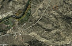
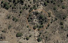
I will post two GE images which contain the clues for the Doc Thorne gold vein, with the west on top. In the first it's more visible the knob and the corral( in blue rectangle), and in the second it's more visible the Sycamore tree ( in green circe ). with yellow circle is marked the gold vein. I will post also a crop from the Mexican map in regards to see how were depicted the placer and the vein.

Thorne vein.png
Thorne vein 2.png
Map to gold placer.gif
 

Last edited:

PotBelly Jim

Hero Member
Dec 8, 2017
900
2,992
Primary Interest:
Other
Silver bullets...and Milton Rose.

Thought you guys might get a kick out of this. If I recall there was a silver mine that was leased on one of the Apache Rez's but I have no idea if this is related.
 

Attachments

  • Silver_Mtn_Milton_Rose_Compressed.pdf
    775.3 KB · Views: 36

sdcfia

Silver Member
Sep 28, 2014
3,661
8,893
Primary Interest:
Other
Silver bullets...and Milton Rose.

Thought you guys might get a kick out of this. If I recall there was a silver mine that was leased on one of the Apache Rez's but I have no idea if this is related.
I like the browning pages of the old mag. Rose seemed to doubt the original tale, but was open to a different location for the silver mine. The White Mountain Apaches are still today very protective of that part of the rez east of Hwy 73 and south of Hwys 260 and 273, especially in that Hawley Lake-Mt Baldy zone.

Frankly, I got a little sidetracked on page 44 of the magazine article into the end of the Madam Barcelo story. For those wondering, here's a complete version of that tale, by W.C. Jameson.
 

Attachments

  • Madam Barcelo.pdf
    2.5 MB · Views: 19

Old Bookaroo

Silver Member
Dec 4, 2008
4,318
3,510
I like the browning pages of the old mag. Rose seemed to doubt the original tale, but was open to a different location for the silver mine. The White Mountain Apaches are still today very protective of that part of the rez east of Hwy 73 and south of Hwys 260 and 273, especially in that Hawley Lake-Mt Baldy zone.

Frankly, I got a little sidetracked on page 44 of the magazine article into the end of the Madam Barcelo story. For those wondering, here's a complete version of that tale, by W.C. Jameson.

Sarge - According to Probert, the article that ended on page 44 is Tom Bailey's "Three Rocks, Two Graves and a Fortune in Gold." If you're looking for a copy, it was reprinted in Gold (Vol. 3, No. 2) 1971. An enthusiast can save quite a bit of money buying the old issues of Gold rather than trying to assemble the individual articles from True West and Frontier Times. Probert's other references are Thomas Penfield and an obscure article in Golden West (July 1971). It would come as no surprise to me if Jameson's source was the Bailey article. I've never found his work to be reliable, accurate, or particularly informative. He's the literary heir of F.L. Coffman, Lieut. Harry Rieseberg, and Penfield.

Good luck to all,

The Old Bookaroo
 

markmar

Silver Member
Oct 17, 2012
4,117
6,259
Primary Interest:
All Treasure Hunting
I know it's out of topic, but I want to put my two cents on Madam Barcelo story.
There is a great distortion of the clues in that route description. Te story tells the pack train traveled in one and half day over 100 miles, because from Santa Fe to Taos are about 67 miles, plus another 40 miles to the east. Seems that party used Santa Claus mules in regards to cover so much ground .
My opinion, the pack train has not traveled more than 50 miles, at the best. They never made it to Taos. So, the best place the bandits could pass from the north and to not be seen, would be behind the first hill in La Junta or behind the smaller hill between La Junta and Rinconada. So, the attack should take place just NE off Rinconada, before the narrow pass along the river which come out in the Taos Valley.
Here are two GE images of the place ( marked with orange circle ) I believe the cargo is buried, place which fits about 90% with the place described in the story. Enjoy and good luck for those interested.
 

Attachments

  • cargo of Madam Barcelo.jpg
    cargo of Madam Barcelo.jpg
    443.5 KB · Views: 30
  • cargo of Madam Barcelo 2.jpg
    cargo of Madam Barcelo 2.jpg
    320.5 KB · Views: 30
Last edited:

sdcfia

Silver Member
Sep 28, 2014
3,661
8,893
Primary Interest:
Other
Sarge - According to Probert, the article that ended on page 44 is Tom Bailey's "Three Rocks, Two Graves and a Fortune in Gold." If you're looking for a copy, it was reprinted in Gold (Vol. 3, No. 2) 1971. An enthusiast can save quite a bit of money buying the old issues of Gold rather than trying to assemble the individual articles from True West and Frontier Times. Probert's other references are Thomas Penfield and an obscure article in Golden West (July 1971). It would come as no surprise to me if Jameson's source was the Bailey article. I've never found his work to be reliable, accurate, or particularly informative. He's the literary heir of F.L. Coffman, Lieut. Harry Rieseberg, and Penfield.

Good luck to all,

The Old Bookaroo
No, I'm not much interested in more of this lost gold story. The interesting Madam Barcelo, a bit of noted early New Mexico character, was a wealthy prostitute and gambler who owned an establishment off Palace Avenue near Santa Fe plaza . However, the Cortez map tale seems to be a complete fabrication, as there is no mention of those people or events in publications other than treasure magazines. This is why most treasure tales, while greatly entertaining, are generally unreliable as far as facts are concerned.
 

markmar

Silver Member
Oct 17, 2012
4,117
6,259
Primary Interest:
All Treasure Hunting
IMO, doc Thorne has been in the region of the placer and the gold vein, twice.
One time when he went for hunting and the stream was dry. In this case he saw the nuggets on the barren bedrock of the stream.
And second time when he went blindfolded and the stream was full of water. In this trip he saw the gold vein.
He was not familiar with the region in regards to understand the similarity. In the first trip he was looking for game and didn't pay so much attention to the details of the region, and the second time he was looking to the west where the vein was located, so no time to look for something familiar which could light a bulb in his memory.
 

markmar

Silver Member
Oct 17, 2012
4,117
6,259
Primary Interest:
All Treasure Hunting
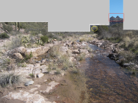
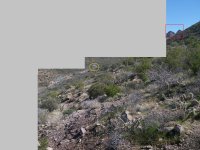
Because in Dr. Thorne are two stories , one about placer gold and another about gold vein, here are two modified pictures of the region where the placer and the gold vein are allegedly located.
And because Sdcfia mentioned a Greek from the Lost Adams Diggings story, I wanted from you to see some similarities of the region , mentioned in both stories , LAD and Dr. Thorne.
In the first picture you can see the stream mentioned in Dr. Thorne story, the Sycamore tree in the yellow circle ( behind the green tree ) and in the distance marked with the red rectangle, two peaks which look like haystacks.
In the second picture you can see marked with a blue dot the place the first picture was shot, the Sycamore tree ( saddle tree ) in the yellow circle, and the two peaks in the red rectangle.

What it's your opinion?
 

Attachments

  • Two peaks.png
    Two peaks.png
    689 KB · Views: 24
  • Sycamore tree.jpg
    Sycamore tree.jpg
    598.6 KB · Views: 24

Top Member Reactions

Users who are viewing this thread

Top