Hi Fellow treasure seekers. I have a background as a hardware/software product developer. I've come across an elusive prospective target for which I'd like to search using a hi-tech drone system. Although many components can now be purchased off the shelf, I think they would need to be rolled together in order to optimize success , the target of which, by the way, I believe to be unusually valuable, and could be anywhere within 25 square miles (no research. has been performed to narrow down the search area, yet). This might be a somewhat long term project: 6 months to a year +. Would anyone on this forum who has serious software or hardware development skills be interested in joining? I look forward to hearing from anyone who believes in the marriage of hi-tech and treasure hunting!
You are using an out of date browser. It may not display this or other websites correctly.
You should upgrade or use an alternative browser.
You should upgrade or use an alternative browser.
Drones & Software - Seeking Treasure Search Collaboration
- Thread starter megghegg
- Start date


99thpercentile
Full Member
- Nov 2, 2006
- 146
- 107
- Detector(s) used
- Geonics EM61-MK2, Geophex GEM-3, GapEOD UltraTEM III, Minelabs F3, Foerster MINEX 2FD 4.500
- Primary Interest:
- All Treasure Hunting
I have done similar projects.
bc5391
Hero Member
- Sep 23, 2016
- 541
- 775
- Detector(s) used
- Minelab ,XP
- Primary Interest:
- All Treasure Hunting
I guess it depends on what you are looking for as to what you need, it sure beats climbing to the top of the mountain to get a look.Hi Fellow treasure seekers. I have a background as a hardware/software product developer. I've come across an elusive prospective target for which I'd like to search using a hi-tech drone system. Although many components can now be purchased off the shelf, I think they would need to be rolled together in order to optimize success , the target of which, by the way, I believe to be unusually valuable, and could be anywhere within 25 square miles (no research. has been performed to narrow down the search area, yet). This might be a somewhat long term project: 6 months to a year +. Would anyone on this forum who has serious software or hardware development skills be interested in joining? I look forward to hearing from anyone who believes in the marriage of hi-tech and treasure hunting!
Attachments
Al D
Bronze Member
Ok, this sounds like a great opportunity, and why has no one thought of doing this before?
spoiler alert….they have, and so have the people who make FAA and state ordinances.
the chances are that you will not get permission to fly a drone within a mile of your target spot.
there are a plethora of rules and regulations which make your project very unlikely, but, I do not want to excrement on anyones parade.
check out the FAA regs on drones and drone sensor systems as well as flight restrictions.
and finally……good luck with your project.
99thpercentile
Full Member
- Nov 2, 2006
- 146
- 107
- Detector(s) used
- Geonics EM61-MK2, Geophex GEM-3, GapEOD UltraTEM III, Minelabs F3, Foerster MINEX 2FD 4.500
- Primary Interest:
- All Treasure Hunting
There are very few places where you can't legally fly a drone. There are places where you need to get a waiver due to being near an airport. There are also some places where it is legal to fly a drone, but it may not be legal to take off and land.
You just need to know what the laws are and what the exceptions are.
You just need to know what the laws are and what the exceptions are.
Al D
Bronze Member
B4UFLY app will help a lot in determining if your target is in a no fly zone.
you also must contend with the rule of maintaining your drone within visual sight, so…even with 20 20 vision, that will mean you will be pretty close to your target, physically. Unless your drone is huge.
as it stands now, national parks, historic sites and designated wilderness areas are no fly zones.
if you are searching for raw materials on BLM land, then you may have a shot, but if it is a lost treasure chances are slim that you can fly there
bc5391
Hero Member
- Sep 23, 2016
- 541
- 775
- Detector(s) used
- Minelab ,XP
- Primary Interest:
- All Treasure Hunting
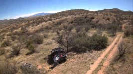
I'm so close to the boarder the only people that might report me are illegal boarder invaders, miles and miles of nothing. To save miles of climbing and or walking, a drone is the best way.Ok, this sounds like a great opportunity, and why has no one thought of doing this before?
spoiler alert….they have, and so have the people who make FAA and state ordinances.
the chances are that you will not get permission to fly a drone within a mile of your target spot.
there are a plethora of rules and regulations which make your project very unlikely, but, I do not want to excrement on anyones parade.
check out the FAA regs on drones and drone sensor systems as well as flight restrictions.
and finally……good luck with your project.
Attachments
Al D
Bronze Member
So…. You are flying without permission, thank you for making my point. 
99thpercentile
Full Member
- Nov 2, 2006
- 146
- 107
- Detector(s) used
- Geonics EM61-MK2, Geophex GEM-3, GapEOD UltraTEM III, Minelabs F3, Foerster MINEX 2FD 4.500
- Primary Interest:
- All Treasure Hunting
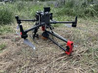
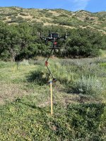
Here are some pictures of my drone mounted magnetometer system and a data plot. I also use LiDAR, photogrammetry, infrared (IR) photogrammetry, and radiometrics from this platform.
Attachments
bc5391
Hero Member
- Sep 23, 2016
- 541
- 775
- Detector(s) used
- Minelab ,XP
- Primary Interest:
- All Treasure Hunting
I like that 99thpercentile, I don,t have the part 107, just a dji mine3, so I don't need it. But Lidar would be nice.Here are some pictures of my drone mounted magnetometer system and a data plot. I also use LiDAR, photogrammetry, infrared (IR) photogrammetry, and radiometrics from this platform.
Secret squirl
Sr. Member
- Sep 15, 2017
- 278
- 313
- Detector(s) used
- pulsestar II pro
- Primary Interest:
- All Treasure Hunting
Can you provide some details on your magnetometer, as well as some information on confirmed depth of targets?
ConceptualizedNetherlandr
Bronze Member
How close to the ground do you have to be to generate that data? TIAHere are some pictures of my drone mounted magnetometer system and a data plot. I also use LiDAR, photogrammetry, infrared (IR) photogrammetry, and radiometrics from this platform.
99thpercentile
Full Member
- Nov 2, 2006
- 146
- 107
- Detector(s) used
- Geonics EM61-MK2, Geophex GEM-3, GapEOD UltraTEM III, Minelabs F3, Foerster MINEX 2FD 4.500
- Primary Interest:
- All Treasure Hunting
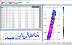
The data above was collected at 30 m flight height since the anomaly generated by the well piping is huge. For smaller targets like UXO, I may use a laser altimeter with terrain following and fly with the sensor 1.5 m above the ground. It completely depends on the target how high you need to fly.How close to the ground do you have to be to generate that data? TIA
99thpercentile
Full Member
- Nov 2, 2006
- 146
- 107
- Detector(s) used
- Geonics EM61-MK2, Geophex GEM-3, GapEOD UltraTEM III, Minelabs F3, Foerster MINEX 2FD 4.500
- Primary Interest:
- All Treasure Hunting
I have used a number of different magnetometers including the Geometrics MagArrow, but I primarily use QuSpin Total Field Magetometer Generation-2 (QTFM-Gen2). I have about 15 of them with many different deployment and mounting options (man-carried, base station, bicycle carried, UTV towed array, UAS mounted single sensor or array).Can you provide some details on your magnetometer, as well as some information on confirmed depth of targets?
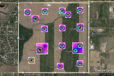
Most of the well heads shown in the figure above are cut off between 10 and 15 feet below ground surface. For small targets such as UXO, they range from ground surface, to just below ground surface, to a maximum depth of about 10 ft. At UXO test sites was always build an in field verification strip (IVS) where we bury industry standard object (ISO) at known locations and orientations. ISO are pipe nipples ordered from McMaster-Carr in three specific sizes that are similar to UXO sizes. We survey the IVS site prior to emplacing target so that we can remove and targets that may already exist there. We iteratively survey the site and remove targets until it is clear. Then we emplace the targets. We then collect data at a range of flight heights starting around 2 m and go up to about 10 m. The flight height with a target on the surface is essentially the same as burying the target and flying lower, with the exception of sites with highly magnetic soils.
I have attached one figure of a UAS magnetometer survey over ISO targets on the IVS at a UXO site.
Attachments
Top Member Reactions
-
 2151
2151 -
 981
981 -
 948
948 -
 945
945 -
 844
844 -
 798
798 -
 796
796 -
 684
684 -
 559
559 -
 548
548 -
 483
483 -
 478
478 -
 458
458 -
O
444
-
 438
438 -
 434
434 -
 418
418 -
 408
408 -
 374
374 -
 362
362
Users who are viewing this thread
Total: 2 (members: 0, guests: 2)