Ft Laramie. on the Oregon Trail

tamrock

Gold Member
Jan 16, 2013
14,965
29,825
Colorado
Detector(s) used
Bounty Hunter Tracker IV
Primary Interest:
All Treasure Hunting
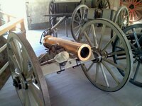
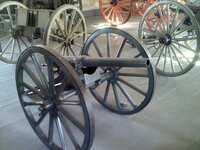
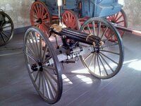
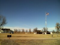
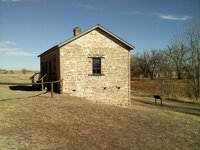
I liked seeing BosnMate's pictures of South pass in Wyoming, so I thought I'd share another point of interest of the old trail. This is Fort Laramie in Wyoming. I've gone out of my why to travel the old Oregon route from Independence Missouri to Oregon City and many parts of it in between over the years as a road peddler. I so enjoy it. It's a great road trip for any family or folks who enjoy history. So much of the route has been left undeveloped and I sure hope it stays that way. The pictures are of an iron bridge across the Platte river. It's said to be the oldest iron bridge west of the Missouri river. Some pictures of the armory with the 2nd oldest and one of only 2 of the type Gatling gun left and some other cannons of the day. The last building is the jail. I wondered how many drunken Cavalry men and renegade natives had spent the nights in that place so many years ago?. I visited the place in December and it was a warm sunny day I remember and I was the only visitor that day. The staff there was wonderful and they told me about all the stuff that's been excavated at the site over the years. One item found was a small California territorial gold bar that was found below the old commissary that you could speculate an old 49'er, must have had on a return trip to the east with his fortune or maybe not and that's just about all he had left to by some goods for the trip back home, because the California idea was a bust?. An other item in the dump found was a broken coffee mug that had the 7th Cavalry cross sabers insignia on it. They had replica's of it made to sell in the gift shop. It didn't have a handle on it. I purchase one, but gave it away to a friend. It's some really cool country around there and well worth the visit.
 

Attachments

  • ft laramie a.jpg
    ft laramie a.jpg
    191.4 KB · Views: 72
  • ft laramie b.jpg
    ft laramie b.jpg
    200.1 KB · Views: 78
  • ft laramie c.jpg
    ft laramie c.jpg
    202.3 KB · Views: 82
  • ft laramie gatling gun.jpg
    ft laramie gatling gun.jpg
    214.6 KB · Views: 71
  • ft laramie e.jpg
    ft laramie e.jpg
    145.4 KB · Views: 60
  • ft laramie g.jpg
    ft laramie g.jpg
    269 KB · Views: 68

BosnMate

Gold Member
Sep 10, 2010
6,916
8,441
Detector(s) used
Whites MXT, Whites DFX, Whites 6000 Di Pro
Primary Interest:
Other
Thanks for the pictures, Fort Laramie was just to far out of the way for me to make it, but it's still on my bucket list. Another fort that is worth the time to visit is Fort Phil Kearny.
That one is on the Bozeman trail. Especially if you have ever read about the Fetterman massacre or the "wagon box fight," which is also a nearby historic site worth the visit.
There are some really great historic places to visit in Wyoming. We ran out of time and never made it to the site of the Fetterman fight, but it's also not far from the fort. If I ever
get the chance I go back to all of those places again.
 

BosnMate

Gold Member
Sep 10, 2010
6,916
8,441
Detector(s) used
Whites MXT, Whites DFX, Whites 6000 Di Pro
Primary Interest:
Other
Tamrock, have you ever done anything on the Overland Trail? During the Civil War, the troops manning forts along the Oregon Trail were moved east, that and the last of the big
buffalo herds were on the Laramie Plains, the Indians pretty much shut down the Oregon trail, and a lot of the westward migration followed that trail during the '60's. Ben Holladay
started the Overland Stage Line, and his route left the North Platte at Julesburg, CO and followed the South Platte to near Greeley, where it split, one branch to Denver, the other to
join the Oregon Trail at Fort Bridger. A lot of that route is probably under I-80, through Rock Springs etc. But that portion of the trail I'd like to explore would be from La Porte on
past Virginia Dale and on into Wyoming where it would end up under the railroad, or I-80. Virginia Dale was named for Jack Slade's wife, and looking back from this distance he was
quite a character, but apparently he was a bad man during back during the day. Love the picture of the Mountain Howitzer. I had a chance to buy one of those for $5,000 when I was
probably 22 or 23, making $1.85 an hour, and supporting a family.
 

OP
OP
tamrock

tamrock

Gold Member
Jan 16, 2013
14,965
29,825
Colorado
Detector(s) used
Bounty Hunter Tracker IV
Primary Interest:
All Treasure Hunting
Tamrock, have you ever done anything on the Overland Trail? During the Civil War, the troops manning forts along the Oregon Trail were moved east, that and the last of the big
buffalo herds were on the Laramie Plains, the Indians pretty much shut down the Oregon trail, and a lot of the westward migration followed that trail during the '60's. Ben Holladay
started the Overland Stage Line, and his route left the North Platte at Julesburg, CO and followed the South Platte to near Greeley, where it split, one branch to Denver, the other to
join the Oregon Trail at Fort Bridger. A lot of that route is probably under I-80, through Rock Springs etc. But that portion of the trail I'd like to explore would be from La Porte on
past Virginia Dale and on into Wyoming where it would end up under the railroad, or I-80. Virginia Dale was named for Jack Slade's wife, and looking back from this distance he was
quite a character, but apparently he was a bad man during back during the day. Love the picture of the Mountain Howitzer. I had a chance to buy one of those for $5,000 when I was
probably 22 or 23, making $1.85 an hour, and supporting a family.
There are a few points of interest along I80 about the old overland route. I'll drive north of the denver area just to drive hwy 30 out Greeley to go along that out route. Julesburg, CO is a nice old town to have a look around. You know Bosnmate I have an old book titled Thirty-one Years on the Plains and in the Mountains by a William F. Drannan. It's the story of this Willy Drannan's life beginning as a trapper with Kit Carson in the 1840's all the way to his involvement in the Modoc wars and some. The book I have was printed in 1899. If you haven't read it you can get new editions on line. It's quite the adventurous story this guy Drannan has to tell and I wondered how much of it was fact and how much was BS. This link has a sample of the read
https://books.google.com/books?id=4...frontcover&source=gbs_atb#v=onepage&q&f=false
 

BosnMate

Gold Member
Sep 10, 2010
6,916
8,441
Detector(s) used
Whites MXT, Whites DFX, Whites 6000 Di Pro
Primary Interest:
Other
Thanks, I love books like that. Just checked Amazon, they have the book in paper back for $10 up, I'm going to buy one.
 

Last edited:
OP
OP
tamrock

tamrock

Gold Member
Jan 16, 2013
14,965
29,825
Colorado
Detector(s) used
Bounty Hunter Tracker IV
Primary Interest:
All Treasure Hunting
Thanks, I love books like that. Just checked Amazon, they have the book in paper back for $10 up, I'm going to buy one.
It's an interesting tail this Drannan writes. I got the sense he was like the Forest Gump of the old west, as he puts himself at so many places of old western folklore. I've researched him some and critics have debunked him and much of his tail, but I did find he was describing many places of the west with some accuracy and he wrote all this down in the late 19th century long before the modern roads and highways were there to get around all those places as he claims he was at over the last 30+ years.. An inscription on a rock found does make you wonder about this mans story. Murder He Wrote: A rock art story | Sharlot Hall Museum Library & ArchivesSharlot Hall Museum Library & Archives Too bad you couldn't have come up with the money to buy that Mountain Howitzer. No telling what one of those, be worth today?. In a book I have, Fremont: Explorer For A Restless Nation by Ferol Egan there's some interesting mentions of the Mountain Howitzer, he added to one of his explorations. Kit Carson ditched it in California and it's still uncertain as to it ever being found again. This link says they believe they found some of it, but are uncertain about the barrel that was on it. Fremont Cannon Hunt My take is the barrel in the Nevada State Museum is the Howitzer used by Fremont. I think this because of the overload bulge in it. In Egan's book that is an account of notes by Fremont, the last mention of the Howitzer, it was said to have been extra charged to create a big boom across a lake to put fear in some natives who were giving the exploration party trouble. Knowing how Fremont thought of all the Military red tape and policies and documenting, that they screwed up a piece of Government property would have given him more trouble then it was worth to him. My take, is Fremont, ordered Carson to place the Howitzer out of site and out of mind when he found a good place where no one will easily find it.
 

BosnMate

Gold Member
Sep 10, 2010
6,916
8,441
Detector(s) used
Whites MXT, Whites DFX, Whites 6000 Di Pro
Primary Interest:
Other
Regarding Fremont's Mountain Howitzer. The story I have on that is they abandoned the gun in the neighborhood of Sonora Pass, due to the steep climb and deep snow. It was supposedly found in the 1880's (From the book, History of Nevada 1886) and was displayed on a guys porch in Carson City. Sonora Pass is now the US Marine Corps mountain training area. I'm inclined to believe the barrel was found and packed off, there is a lost cannon mountain and a lost cannon creek just north of Sonora Pass, and Walker River is also north, but it's been a long time and I'm hazy on locations down there. There might very well be ammunition and it looks like those guys found iron carriage parts. The road over Sonora pass is a real booger, took my wife over, and she threatened to assume the fetal position
on the floor until we were over the top. Don't know about the bulge in the barrel, but I've been close to where they camped. My intention was to try and find the friction primer from
that shot. There is a road out to it, but at the last 1/4 mile or so, there is a closed gate. It's located on private property on the Klamath Marsh, I didn't have permission to go out
there, and on top of that, the Feds have a Wildlife Preserve on the marsh, and their headquarters are directly across from the point where the camp was. In that marsh area there are
signs, in fact a lot of signs that say, "NO ARTIFACT COLLECTING," along with the penalties if you even pick up an arrowhead or any rock. Typically, I didn't have a lot of time, I was heading
to hunt elk quite a distance away, so did the right thing, and obeyed the law, and only took pictures. They still call it the Klamath Marsh, but a lot of it has been drained and turned into
pasture. However the wildlife preserve is still marsh, and where the paved road crosses the marsh is still there. Where Fremont camped the marsh has been drained.
This picture is looking west. I'm in the marsh where Fremont probably crossed, it's very narrow right here. The pointed peak is Mt. Thielsen, and Mt. Mazama (Crater Lake) is to the left out of the
picture. I'm taking the picture standing in the Military Road. The Indian wars in central and eastern Oregon were the best kept secret until the Atom Bomb. The government wanted
people to move to Oregon, and the Indians didn't want them, so there were battles and forts, and the military road across the marsh.
1.jpg
There is a road that turns off the military road just behind that farm house, and I drove out to the point. I was driving in Lodge Pole Pines, and there is a fence along the marsh pasture,
so I'm assuming the Lodge Poles are BLM land. Like I said, I drove all the way to the point, only to find a gate, and I was able to look across and see the Wildlife Preserve headquarters,
and after reading all those signs my heart really sank. The arrow points to where Fremont camped in 1844. The reason for the cannon shot. In 1828 Jed Smith and 19 trappers were
driving a herd of horses purchased in California up the Oregon coast. Camped at the mouth of the Umpqua River, all but 4 of his men were killed, and he lost all his horses to the Umpqua
Indians, or as one of his men had phonetically spelled the name, Oomp Quak, and the distance over the mountains to the coast was unknown, so they were worried to begin with, and
supposedly the Indians that lived out in/on the Marsh on houses built on stilts, were acting menacing. So the only time the gun was fired was at that time. He fired an explosive shell timed
to blow up over the marsh, everything went quiet, then the next morning the Indians visited camp to see what kind of gun he had that would shoot twice. This information I've gleaned
from some pretty good primary source material.
3.jpg
And the next picture is a telephoto showing the point where they camped. The pasture is drained marsh land. Their camp was on the second or furthest point. The picture is looking
north, northwest.
2.jpg
 

Last edited:
OP
OP
tamrock

tamrock

Gold Member
Jan 16, 2013
14,965
29,825
Colorado
Detector(s) used
Bounty Hunter Tracker IV
Primary Interest:
All Treasure Hunting
Thats all so interesting there BosnMate, That's not the kind of terrain I pictured of the marsh from the book. I had an image of a marsh or lake, higher in the mountains surrounded by a dense forest of huge trees. I like Fremont and how he organized his expeditions. He was a good leader. I read where he held a contest for a daguerreotypist to go along on an expedition. The one who could demonstrate the best ability and knowledge of the daguerreotype would get the job. You could tell Fremont wanted have the best technology and tools of his time and the right people for the job, to have along on his ventures. He was also a man who didn't choose a man by the color of his skin, religious beliefs or status. If you could prove your fit for the job then you could have it. It's not like today in these ways of being fair and tolerant is how one is chosen for a position. This is a link to a Jewish fellow that Fremont gave the job to as a daguerreotypist on one of his last expositions. The oldest known image of the plains Indians was shot by this fellow. His name is Solomon Carvalho. Unfortunately this is the only photo of his venture with Fremont know to exist, as all the other negatives are said to have burned up in a fire in his studio back east some place I think I read. NCJF Fiscal Sponsorship: Carvalho's Journey
 

Last edited:

BosnMate

Gold Member
Sep 10, 2010
6,916
8,441
Detector(s) used
Whites MXT, Whites DFX, Whites 6000 Di Pro
Primary Interest:
Other
Thought I'd post some Google Earth pictures, but they are pretty cluttered, and my notes on them are sort of hard to read, but might give a better of the lay of the land, more so
than my photographs.
This first one kind of gives an over all picture with Crater Lake to the left and Summer Lake to the right, the marsh in the middle. Fremont crossed the marsh, struggle through
deep snow heading east, and came out at Winter Ridge. He was standing on the ridge in a snow storm, looking down at the lake in wonderful sunshine. Fremont named it Winter
Ridge and Summer Lake. There is a park at Summer Lake, and a sign that says Fremont fired his cannon out over that lake, but if you read what Fremont himself said, that is
totally not possible. Click on the picture and it will enlarge to a readable size.
3.jpg
The next two photos are closer up, and show a little more detail.
2.jpg
1.jpg
The last picture shows the military road at the bottom, and my pictures were taken from the road about where the O where is says "Image stare of Oregon."
 

Top Member Reactions

Users who are viewing this thread

Top