Marco Marco
Greenie
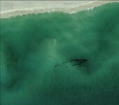
I have been observing for about six months now. I have gotten alot out of the site. I came across this while on google earth. I used a vehicle at the same height to measure the ship. It is approx. 150 long. I check the USCG charts and it has been sounded by them and marked as an obstruction. What I need is some information on the restrictions that are on the charts they send me to the legend but then that sends me somewhere else. The wreck is off the coast of a National SeaShore Area and Federal Land. I know it has not been check out from the beach because the area can not be accessed. I would like to dive the wreck from the water approach but don't want to be arrested. are there any Laws that prevent me from diving the wreck if i approach it from the water. Also can any one make out weather the hull is metal are wood.
Thank You
Thank You