How do you use your historic maps?

Yukon Cornelius

Tenderfoot
Jan 7, 2013
8
1
Butler County, PA
Detector(s) used
Bounty Hunter Quick Draw II
Primary Interest:
Metal Detecting
I realize this may sounds like a dumb question, but with as many historic maps as I have found on the web, I am wondering...what techniques do you all like to use to pin point a location (old houses, etc) on a map?

I have looked at some maps and they don't have scales on them, but offer details that other maps don't. Obviously those could be correlated to one another if you can verify the location of the homes is the same.

The reason I ask is because I looked at a site (historic aerials) and it overlaid an old topo map with the current day map. The problem is, I don't know how confident I am that the coordinates are accurate because when you zoom in the resolution of map is lost and scale is thrown way off. I have located to home sites that may date back to mid 1800s and possibly before, but are no longer there...what is in there place is a field owned by a person that I am friends with. I'm sure it would be no problem to guess at it and try to walk through the field when it's not planted to have a look and see if I can find anything, but not sure if I also would be wasting my time.

Do you have a different technique for map overlay/coordinate comparison for modern day?

I hope this isn't too general of a question, but I guess in summary, what do you find to be the best way to pin point old home locations that you may find on old maps?

Thanks in advance!
 

OP
OP
Y

Yukon Cornelius

Tenderfoot
Jan 7, 2013
8
1
Butler County, PA
Detector(s) used
Bounty Hunter Quick Draw II
Primary Interest:
Metal Detecting
Land Records

I'm sure many of you already know of this...not sure completely how to utilize it yet, but hope it can help some of you. Great resource, tons of maps from a wide time period.
 

Metal Detecting Stuff

Supporting Vendor
Supporting Vendor
Mar 19, 2012
6,746
1,073
Spring TX
Detector(s) used
CTX3030/F75LTD/ Garrett AtPro/ XP Deus
Primary Interest:
All Treasure Hunting
You are on the right track, using an overlay on Google Earth is the way I do it. Usually, you can find enough landmarks, roads, etc. to stretch the overlay to close to scale. Once you find the old buildings on the topo, go in the field and listen for the conentration of iron. When buildings are torn down, the nails usually end up in the soil.

The Minelab CTX3030 has a gps feature, so I can actually load the coordinates from the map into my detector. Once I get to the pasture, it directs me right to the spot where the coordinates match.

Wayne


www.metaldetectingstuff.com
 

OP
OP
Y

Yukon Cornelius

Tenderfoot
Jan 7, 2013
8
1
Butler County, PA
Detector(s) used
Bounty Hunter Quick Draw II
Primary Interest:
Metal Detecting
Thanks wayne,

I don't think I can spend $3,000 on a MD right now as I hardly know how to use the one I've got... But I do have a GPS and can use it as well as the one I have.

Once I get a hang of it I may step up to a nicer detector.

I appreciate the input on google earth, I just came across a different article discussing that last night.

Thanks again,
Andy
 

Reed Lukens

Silver Member
Jan 1, 2013
2,654
5,418
Congres, AZ/ former California Outlawed Gold Miner
Detector(s) used
Tesoro Vaquero, Whites MXT, Vsat, GMT, 5900Di Pro, Minelab GPX 5000, GPXtreme, 2200SD, Excalibur 1000!
Primary Interest:
All Treasure Hunting
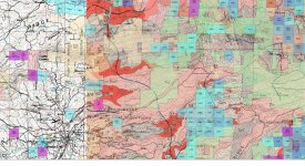
There are other programs like the BLM ARC-GIS mapping program where you can overlay all types of different maps and layer them together. The Geocommunicator used by BLM and available online still does this but isn't available to the extent that it used to be. It does come up, the overlay map works, but the main sets of layers is only available to them now in their office. I use the GPS system as well with Google Earth these days, it's easy & can be scaled to overlay any other old map that you have. This is an old picture of a BLM gis map with a bunch of different layers. The green is the standard topo, which is set as the base map, then it has many different overlays like the tertiary channel map in orange, then the white historical map on the left. Then it had active mining claims though this is 10 years old now in blue. You used to be able to get really extravagant & add in rivers, streams, arials or whatever. * this is what BLM has in the office that we used to be able to access. They had to shut it down years ago because of hackers & it was costly. I saved a few pictures for reference. You have to really look to see that these are actually a bunch of different layers from many different maps. I have a friend who runs GIS data for BLM every day as their job. It pays good & GIS is a highly specialized field.

IdeaMXD.jpg
 

OP
OP
Y

Yukon Cornelius

Tenderfoot
Jan 7, 2013
8
1
Butler County, PA
Detector(s) used
Bounty Hunter Quick Draw II
Primary Interest:
Metal Detecting
Thanks Reed,

I just found a plug in for google earth which uses all the old topo maps. A big help and a lot easier than me trying to overlay images for the same purpose.

I located 2 house and an old road bed from a 1910 topo... Now a field/woods owned by a friend. I guess that is a good place to begin.

Thanks again for the help/info!
 

DiggItUp

Full Member
Mar 9, 2013
200
61
So i download google earth first then download the plug-in? not sure how this works ill see if i can figure it out.
 

DiggItUp

Full Member
Mar 9, 2013
200
61
Like im on the plugin but its really annoying and hard to use... I HAVE THE PLUG IN CHECKED but whenever i click on the point of the highlighted area it doesn't have any blue links to click on with dates... really annoying i can only get it to work if i click on my state, then go to my area and it doesnt even give a date of which map its showing just really wierd and annoying,
 

TreasurePirate69

Hero Member
Jan 20, 2012
589
196
Primary Interest:
All Treasure Hunting
You might also look at Sanborn maps. I find these to be fairly easy to use. However, they are limited to towns and cities.

Love your screen name by the way. Good ole Yukon is one of my all time favorite treasure hunters. :thumbsup:
 

WilliamH

Sr. Member
Dec 20, 2012
295
120
Sanborn maps are great. Thanks for the advice. Just looked it up and now I have to hit the library. Can't wait. Never thought I would say that.
 

Top Member Reactions

Users who are viewing this thread

Latest Discussions

Top