How to Approach Scouting a Gravel Bar for Placer

ChefCat

Tenderfoot
Sep 24, 2019
7
8
NC
Detector(s) used
Not using one, yet.
Primary Interest:
All Treasure Hunting
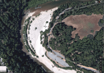
I have been doing some research and found this location on public land in Washington State that I would like to scout for highbanking. USGS indicates that this oxbow has iron placer deposits right around the blue line. They did not indicate gold as a secondary commodity by this survey from the 90's. Other research points to the fact that this creek has had good gold deposits in the past. I want to scout it out but am unclear in how to approach scouting a gravel bar via test panning. My instinct points me to start in the regions indicated by the red and blue lines, behind rocks, and under banks. I am looking to highbank so it makes sense to look for a paystreak I can work. How would you approach testing an oxbow bar such as this? Would you start by looking around the shore, closer to the water line, solely behind rocks? How deep do you typically test before moving on to the next hole?

Thanks for the help!
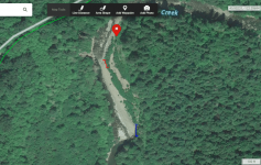
Gravel Bar Question.PNG
 

Upvote 0

et1955

Hero Member
Jan 10, 2015
913
1,784
Shoreline,wa
Detector(s) used
Equinox 800
Primary Interest:
Prospecting
From my experience mine the inner channel near the "x" you marked, if it easy you will not find gold, some of the many rivers I have mined in this state there is no gold near the water but there are exceptions but rare but on one river I mine I average one gram panning per hr. but I am over 100ft. from the river. Before you bring in your highbanker, test with your pan to make sure it is worthwhile. It is Knowledge and experience that determines how much gold you get not the equipment you buy. Goodluck
 

brianc053

Hero Member
Jan 27, 2015
974
3,371
Morris County, NJ
🏆 Honorable Mentions:
3
Detector(s) used
Minelab Equinox 800
XP Deus 2
Primary Interest:
Metal Detecting
ChefCat, I'm not an expert but have some opinions based on what I've learned from others since I have asked this exact question before about a frequently prospected river in New Hampshire, the "Wild AM."

First, if this is an oxbow is there water flowing? It kind of looks like an active stream/creek to me. Second - and forgive me if this is obvious to others - if there's flow, in the picture is the creek flowing from the bottom to the top? I believe this is the case from the flow near the blue line and the red line, but I want to confirm.
I'll assume it has flowing water from bottom to top.

The first thing I'd be checking for is flood gold, the smaller gold that moves when a storm increases the water flow. You can check for that behind any larger rock, but the area just to the left of your red line looks like a good spot where some flood gold would drop out. Why look for flood gold? Because it's nice to see some color in a pan and if you find it that will tell you there's more gold to be found. Sounds obvious, but it's a quick way to gain confidence in the location with just a pan, classifier and shovel.
Even if you don't find flood gold there could still be gold deeper in the bar, of course.

Now for a key question: is there exposed bedrock anywhere in the picture? If so that should be a target area, and working the gravel downstream from that bedrock and in the cracks of that bedrock should be the priority. I'm not sure what is to the left across the creek from your red line, but if that's bedrock then just downstream (up in the picture) from the red line should be your priority area.
If there is not bedrock exposed, do you know how deep it is to get to bedrock? Can you/Are you wiling to dig a hole to find out? Keep in mind that I'm a dredger and not a high banker usually, so I'm obsessed with cleaning off bedrock. But I'd figure that even with a high banker you want to dig on bedrock if possible.

Looking at the picture, assuming flow is bottom to top, and assuming you want to move more material with the high banker, your blue line area is interesting but I think you want to actually dig on the opposite side of the creek (the inside bend, as the water seems to curve to the left a little). That triangle shaped bar in the middle of the creek near the blue line is interesting.

The water seems to slow down between the blue and red lines, as indicated by the large bar on the right. A lot of the gold would drop nearer the blue line, but in large storms/flows it could easily move toward the red line and that does look like another interesting area. The whole bar could have some gold mixed into it - meaning you could be high banking for a long time!

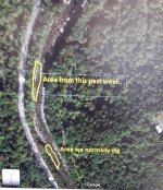
Here is a picture of a pretty well known publicly accessible area in California, the Bear River (near the campground). I've dug in multiple places in this bar and there's gold mixed all through the material. It's where I found my largest flake to date, the size of a (small) cornflake. My reason for showing this is that I couldn't tell you where to dig because the whole bar seems to have gold.
1rvlzJ5.png

And here's one of the Wild AM in NH that I don't mind sharing because I don't think it gives away secrets. Both "areas" noted produced decent gold and the difference was minor between them. (We had to dig the outside bend because the inside bend is private non-accessible property)
T69HfNJ.jpg

I guess I share those pictures because:
- either your creek has gold or it doesn't; finding flood gold will help determine that.
- If your creek has gold, there's probably gold to be found everywhere, and your question is more about where it will be concentrated.

Have fun, good luck and please tell us how you do.
If any experts would like to correct anything I've said, please do - as I stated I'm not an expert but think I've learned a thing or two along the way.
- Brian
 

Goldwasher

Gold Member
May 26, 2009
6,077
13,225
Sailor Flat, Ca.
🥇 Banner finds
1
Detector(s) used
SDC2300, Gold Bug 2 Burlap, fish oil, .35 gallons of water per minute.
Primary Interest:
All Treasure Hunting
with a gold pan
 

Underburden

Sr. Member
Mar 22, 2012
484
1,125
Idaho
Detector(s) used
Gold Hog Stream Sluice
Primary Interest:
Prospecting
Google Earth will never replace these!
boots.jpg
 

JeffA

Jr. Member
Jun 13, 2019
65
63
RI
Primary Interest:
Prospecting
Test pan all over the place, would be my best advice. Look for where larger rocks have settled from when the water flow was higher. Good luck, and keep us posted on how you do! Jeff
 

Top Member Reactions

Users who are viewing this thread

Top