Humminbird 987c SI side-imaging sonar...anybody got one?

pcolaboy

Hero Member
Sep 5, 2006
916
14
Pensacola, Fl
Detector(s) used
Minelab Explorer XS
I was wondering if anyone on the Forum has the new Humminbird 987c SI GPS/Fishfinder/Side-Imaging sonar unit? From what I've read about it on their website and the sample images it contains, I would think this would be a pretty affordable imaging solution.

If anyone has this unit I would like to ask the following:

1. Do you use it primarily in freshwater or saltwater?
2. How slow do you have to be traveling to obtain images?
3. Can you set to record the imaging in real-time or can you only take a "snapshot" ?
4. Once you have located something, lets say 100 feet to starboard, does the unit give you an accurate Lat/Lon of the object if you mark it or does it only mark the location of the vessel you are traveling in?
5. I know that it is only rated to scan 200 feet out to the sides down to a depth of 100ft, does the resolution significantly taper off as you increase depth?
6. Is there a PC application that comes with the unit to playback/manage the imaging data?

The depths that I would intend on using this puppy are less than 100' of saltwater with mostly sandy but some muddy bottom.

Thanks in advance,

Pcola
 

rgecy

Bronze Member
Jun 14, 2004
1,910
59
Beaufort, SC
Detector(s) used
Garrett Sea Hunter Mk II
pcolaboy,

Welcome to the forum. Congrats on the wreck you found. We would love to see some picts. I will try to answer your questions on the Humminbird Unit. I have had mine now for about 6 months and use it almost daily.

1. Do you use it primarily in freshwater or saltwater?
I use mine primarily in Salt water, but the resolution in fresh water is even better.

2. How slow do you have to be traveling to obtain images?
I usually stay between 4 and 6 mph. Any faster and the images will be distorted from engine/propeller noise.

3. Can you set to record the imaging in real-time or can you only take a "snapshot" ?
Snapshot only!

4. Once you have located something, lets say 100 feet to starboard, does the unit give you an accurate Lat/Lon of the object if you mark it or does it only mark the location of the vessel you are traveling in?
It marks the location of the vessel. You kind of have to determine the offset on your own. I haven't had any problems with this. I scanned a boat in 100ft of water and calculated the offset, told my partner to drop anchor and the anchor landed right on the boat. Once you learn how to read it, you will not have any problems.

5. I know that it is only rated to scan 200 feet out to the sides down to a depth of 100ft, does the resolution significantly taper off as you increase depth?
Actually the unit will read out to 340ft each side. I find the resolution tapers off around 75ft. This unit is best suited for shallow waters (less than 50ft). Especially if you leave the transducer hull mounted. The way to overcome this problem is build a towfish and extend the cable. I have not finished mine yet, but will certainly let you know how it turns out.

6. Is there a PC application that comes with the unit to playback/manage the imaging data?
No, this is one area that I think they could greatly improve. If this unit had the ability to record the data and play back like the lowrance/eagle units, it would put it over the top.

Overall, I am extremely satisfied with my 987c. Once you understand how to work it and read the images its amazing. I have had several friends who saw mine and immediately went out and bought their own. It is the most affordable solution on the market for the novice/begginer wreck hunter.

I hope this helps!

Robert in SC
 

ScubaFinder

Bronze Member
Jul 11, 2006
2,220
528
Tampa, FL
Detector(s) used
AquaPulse AQ1B - AquaPulse DX-200 Magnetometer
Primary Interest:
Shipwrecks
Excellent info guys, wish i had something to add other than I could have bought this unit for what i paid for JW Fishers SSS training this weekend :( The fishers unit is almost 9 times the cost of this one too. It was still cool to learn, and I got mag training and some experience with the pitfalls of towing a fish too.

Robert, definitely post when you get your tow fish built and tested, I am insanely curious! I have a buddy who is a electrical engineer and his job is automating non-automated machines and gathering the data from them. I may buy one of these units and get him to build a real time data logger/playback unit for it. He would at least draw up schematics for it so anyone with a good soldering iron could build their own...probably. I'll talk to him and see what he thinks.

Just to make sure I have it right, the addition of data logging and real time playback is the main thing missing? Also, I assume the playback needs to take place on the boat, and not just create a file that could be played back later right? The reason I ask is that playback after the fact would be simple to do with a common SD memory card like our digital cameras use, so if that is good enough, it might get a little easier to build and a lot cheaper too.

Give me some ideas and we just might be able to make something work.

Jason
 

rgecy

Bronze Member
Jun 14, 2004
1,910
59
Beaufort, SC
Detector(s) used
Garrett Sea Hunter Mk II
Jason,

What I would be most interested in is some sidescan software that would hook directly to the transducer and record real time sonar data. Software would solve a lot of the problems with calculating gps offset and layback of a towfish.

The transducer is multi freq. I wonder if we bumped up the voltage little going to the transducer if this would give better depth and distance.

But, even if there was a way to log all the data and play it back on a computer at home would be awesome. I would be interested to see what you could come up with.

Have you ever visited Carl Morelands Geotech Forum?

Robert in SC
 

rssharpetx

Jr. Member
Sep 6, 2006
38
0
If you know the depth of your towfish you can figure your layback (concatenary curve) I got some old software that figures layback.....I will try and locate and post a link.........We have a free bee download called Buoy available online this may help......you just have to estimate the drag coeficant for your cable diameter (vary small for xducer cable) use the tow body example on the buoy software download....play around with it and you will get the idea.....its DOS and old but works great....I will get back to you on layback SW...oh ya demo software is at www.specialtydevices.com and once again program is called BUOY


Regards

Scott
 

OP
OP
pcolaboy

pcolaboy

Hero Member
Sep 5, 2006
916
14
Pensacola, Fl
Detector(s) used
Minelab Explorer XS
WOW thanks for the great feedback!!! I definitely put greater value on an actual "power-user's" opinion than any sales pitch - thanks!.

I actually have a bid on one of these units through Ebay but I'm certain that I won't get it for half the retail price which is my current bid and budget :P . Keepin' my fingers crossed !!!

Pcola
 

SEAHUNTER

Hero Member
Jan 10, 2006
841
106
PALM BEACH COUNTY,FLORIDA
Primary Interest:
All Treasure Hunting
Scubaseeker
Where did you go for the training on the JW Fishers equipment and how much did it cost?
Seahunter
ps. How much for the Hummingbird?
 

ScubaFinder

Bronze Member
Jul 11, 2006
2,220
528
Tampa, FL
Detector(s) used
AquaPulse AQ1B - AquaPulse DX-200 Magnetometer
Primary Interest:
Shipwrecks
SeaHunter, I went here of course! See the plane?

athens.jpg


Here is a side scan image of it!

sssplane.jpg


The class is $1,000 (2 days - Sat. & Sun.) plus $20 per day + tank fills + any rental gear you need. It's taught by Calvin Wilcher, who is a treasure coast savvy die hard treasure hunter himself (with a silver reale necklace around his neck no less). He uses a Fishers SSS and a Pulse 12 (just like yours) towed behind his pontoon boat for the class. The lake is only about 40 feet at it's deepest point, and even that is only if Texas has gotten a lot of rain. ;) I bought my Pulse 8X from him while I was there, and got some invaluable tips to boot!

Athens is a small town about an hour south of Dallas Texas, his facility is an old rock quarry that has about 10 boats, 2 aircraft, a VW Beetle, a golf cart, 3 buses, a grain silo, a space capsule, and just about everything else you can imagine in it. It was worth the trip just to dive on all the stuff. The class is great, it's two very full days, but he really gets into the details with you. http://www.athensscubapark.com

See you soon, if I can stop spending money on all this equipment and training...put a bid in on a Brownie Hookah today ::)

Jason
 

ScubaFinder

Bronze Member
Jul 11, 2006
2,220
528
Tampa, FL
Detector(s) used
AquaPulse AQ1B - AquaPulse DX-200 Magnetometer
Primary Interest:
Shipwrecks
Well I didn't get much encouragement out of my EE buddy. He went on and on about proprietary image formats and data decoding algorithms and other stuff that made my head spin. His basic thought was that if someone had released or leaked the code in an open source format then no problem, if not, it would be virtually impossible. Does the unit have any output ports on it already? If it was made to print or display on an external monitor or something that might change things, if not, we are probably done with that idea.

The chances that Hummingbird has released that info are slim to none, so I guess that's another of my grand ideas put to rest ::)

The only grand idea I've had that I still LIKE is the one where I move to Florida and get my butt in the water :D

Jason
 

ScubaFinder

Bronze Member
Jul 11, 2006
2,220
528
Tampa, FL
Detector(s) used
AquaPulse AQ1B - AquaPulse DX-200 Magnetometer
Primary Interest:
Shipwrecks
I'll second Peg Leg's request...Sub-bottom profiling is something I have not been able to find much info on either. Seems like for the 1715 lease (and Peg Leg's project), this would be the technology to have.

Jason
 

rssharpetx

Jr. Member
Sep 6, 2006
38
0
Peg

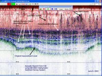
WE sell a shallow water sub-bottom profiler (multi freq ) but it gets kinda pricey. I sometimes get out and demo unit in florida (free bee). I will post next time in advance and possibly squeeze in a demo at your site. I sent a data record for your review. As always max penetration is dependant on bottom type sand, silt etc etc. More info at www.specialtydevices.com look at reservoir sediment mapping.... I am not giving you a sales pitch just showing you some new technology that works. We typically get 1 to 2 meter penetration in SAND......much much deeper in other bottom types.

Regards

SCott
 

Attachments

  • TXUC30.JPG
    TXUC30.JPG
    119.7 KB · Views: 2,823
  • c30subrecord.jpg
    c30subrecord.jpg
    86.6 KB · Views: 1,843

Peg Leg

Bronze Member
May 29, 2006
1,520
5
The scan are great if I was able to understand what I am looking at but it apperas to have been done on LAND
Do you have any this showing what it looks like in a river or ocean/?
Peg Leg
 

rssharpetx

Jr. Member
Sep 6, 2006
38
0
Peg Leg,

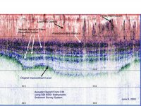
That is a reocord done on the water.....What you are looking at is water then bottom then multiple layers of sand,then gravel etc. stratification....LAYERING of SUB -BOTTOM material...All of the red fuzz at top of record is aquatic plant life in the water....It is from a lake in the summer. The water starts at the top of record and end at the label water/sediment interface The pre-impoundmant layer is the"bedrock" I will post another plot with not as many confusing details. Hope this helps All my plots are in tif format I will convert and post shortly

Regards

Scott
 

rssharpetx

Jr. Member
Sep 6, 2006
38
0
Peg ,

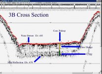
here is cross section of river channel. Look at it like a depth sounder output ..... the top of record is surface ,..... then the bottom refection ...then the sub-bottom stuff. The cross section has a core location plotted towards the middle....this was plotted for demo of another product I am having problems shrinking file size so I can post this plot.....email me and I will forward picture

Regards

S
 

rssharpetx

Jr. Member
Sep 6, 2006
38
0
Peg,

Here is another plot.. not so many reflections on record...you can see typical 3 to 6 ft of penetration..I finally figured out how to shrink pic size...........$ is 60k and up....bells and whistles type thing......As stated I will EM you next time I demo in florida and you can see with your own eyes. Good hunting

Best regards


Scott
 

Attachments

  • 3bcross_coreLS.JPG
    3bcross_coreLS.JPG
    69.5 KB · Views: 1,623

Peg Leg

Bronze Member
May 29, 2006
1,520
5
Someone out there must have a scan showing objects on the bottom of the ocean. I can not tell anything from the scan presented.
Peg Leg
 

ScubaFinder

Bronze Member
Jul 11, 2006
2,220
528
Tampa, FL
Detector(s) used
AquaPulse AQ1B - AquaPulse DX-200 Magnetometer
Primary Interest:
Shipwrecks
I can see where it would be helpful in determining the amount of overburden you were looking at at a particular location. The thing I miss is a scale showing the horizontal distance each scan is looking at. It appears that both banks are present, so I assume that is an entire body of water scanned from one side to the other?

If so, it would seem that the resolution would make it hard to pick out a wreck in the substrate. Wouldn't it take a pretty large object to cause a noticable spike in the hard bottom?

Jason
 

rgecy

Bronze Member
Jun 14, 2004
1,910
59
Beaufort, SC
Detector(s) used
Garrett Sea Hunter Mk II
A sub-bottom profile is not easy to read. I had the privilege of reading my first sub-bottom profile on my trip to Key West last weekend. Basically it sends sound waves into the sea bed and penetrates into the differnet layers. An object will return a reflection that will seem out of place or looks un-natural to the surrounding layers. A shipwreck may have more vertical returns that disturb the natural contours.

It takes a very trained eye. You definitely have to know what you are looking for.

I have been told that some of the older chart recorders like the x-16 that use the 50kHz transducers can be used as sub-bottom profilers by increasing the voltage through the transducer. Supposedly it will only penetrate a few feet depending on the bottom material. I haven't tested it, but it may work.

Has anyone had any experience with this?

Robert in SC
 

Top Member Reactions

Users who are viewing this thread

Latest Discussions

Top