I'm using a friend's computer, and they don't have google earth on their computer. Once I get home again, I"ll certainly look it up. It'll be a few days though.
Unless you wanted to post a picture of it (there are directions for that on the google earth website).
HI, I believe that that is basically bottom/low land or old pond sites. There was water there which formed the variation of the soil. Perhaps yearly with the rains.
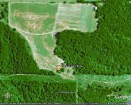
It would be helpful to have some context to this. What is it you think you see? Is this a rural mountainous are? What is the white building? in the upper RH corner, a barn? Is this a cow pasture and cowpaths, and deer trails around the other wooded areas? What are the objects next to the building? Sheep? Pigs? Goats? Yeti? Nudists?
the white things are farm equip....(tractor-hay conditioner and bailer) no cows the lines at the bottom are old roads that are mostly grown up never used
I'm not really sure what you are referring to but the cleared stip of land running horizontally at the bottom looks to like a power line or gas line right-of-way with a service road (trail).
i was refering to the trees under the marker....i thinks its weird that the hole field is cleared except for that spot ...i dont know ....could be anything i supose...
I think you'r stretching it a bit there. Looks normal to me. There are millions of tree 'setups' like this.
Different type of tree, was not cut, may have been a house between the several trees.
well found out who owns the land and he took me out there and this is what was there.......................................................................................................
thats right not a thing just an old spring in the patch of trees ...he said from what he was told when they cleared the land they left the trees around it so they had a cool place to take a rest and get something to drink....thinks for all the replys p.s. the pond is new