Legends, Maps, Coincidences, Logic, and Hunches.

Dirty Dutchman

Sr. Member
Dec 27, 2010
324
72
Arizona
Detector(s) used
My Brain
Primary Interest:
All Treasure Hunting
[quote it doesn't tell us what sort of weapons they were using themselves.

Good night Travis, I look forward to your replies. :thumbsup:
Oroblanco

:coffee2: :coffee: :coffee2:
[/quote]

Oro,

This is what i have been trying to say and where i disagree with you. The Walker/Weiser story DOES tell you what kind of weapons the Indians were using.

1)The horse was brought down by-ARROWS
2)Weiser had two wounds to his shoulder by-ARROWS

Now, you may be correct, the Indian could have gotten his gun and went back to his camp to "finish off" the Frying pan but, it doesnt make any sense to me.

I guess arrows and frying pans really dont matter and we will probably never know for sure. Unless there is a frying pan out there with a few holes in it!

Thanks,
Travis
 

FEMF

Full Member
Sep 10, 2009
158
86
Oroblanco said:
Dirty Dutchman wrote
Oro,
While i agree the Indians could have "poked" holes or used other weapons, this doesnt seem logical for someone that seems to believe the Weiser story. I assume since you talk about it that you do believe that story?

When Weiser is telling his story, he says that he was keeping the Indians away using his rifle (while he was fleeing). They were afraid to get close. His horse was brought down finally by their arrows. No gun is mentioned. I believe they were afraid to get close because they didnt have guns. Again, just my opinion on what ive read.

I probably dont know as much about Indian history as you do, but i cant find a "gun" story in the Weiser/Walker part (other than Weisers), so i'm going to stick with what i said earlier.

Thanks,
Travis
(I'm out for the night!)

Yes I do accept the Weiser story, in large part because of my opinion of Dr Walker. As owner of the famous Vekol mine he had no need to go risk life and limb to hunt for it, plus his record of fighting the Apaches left a rather large target on his head for the rest of his life.

I am not saying that there must have been firearms in the hands of the Indians attacking Weiser, only that any holes found in a frying pan may have been the result of a firearm or possibly just poked through. Perhaps the victorious warriors obtained a firearm from Weiser's own camp? We can't really say. Perhaps they recovered Weiser's own rifle, which he left at the water hole in his flight. I would not say that the Indians must have been Apaches for that matter, they may as easily have been Yavapais or even Navajos, depending on what year the attack happened.

The bloody shirt and frying pan are not in the Weiser story we get from Dr Walker, which is only logical as he fled the scene of the attack. As for the reason why the Indians were hesitant to close the distance with Weiser, the fact that they stayed back really only indicates their respect for the rifle he was using, it doesn't tell us what sort of weapons they were using themselves. It may be an indicator of the ID of the Indians involved however, which may point to a different tribe than the Apaches as is usually assumed by most.

Good night Travis, I look forward to your replies. :thumbsup:
Oroblanco

:coffee2: :coffee: :coffee2:

Hello Oro
I've been trying to find a direct connection between the Navajo's and the Superstition Mountains, and can't seem to find anything! Can you point me in the right direction again?
Thank's Again!
FEMF
 

OP
OP
EE THr

EE THr

Silver Member
Apr 21, 2008
3,979
38
Central California
So, Travis, your answer is just "the Mexicans"? Well, OK. For some reason I thought it sounded like you had a theory about Waltz, which would be based on his background, like previous occupations, or something like that, causing him to "think" differently. Shucks!

But now I see what you meant. Sorry for the confusion.

Anyway, here are some things to consider.

The Mexican maps start, according to the John Mitchell Timeline, in 1846, about 25 years before Waltz supposedly went to Mexico, and became involved with the Peraltas and their story.

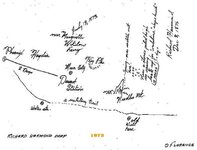
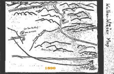
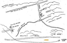
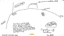
I'm going to start with the first maps which are said to be directly related to the LDM, again using the timeline above, and the maps from The Lost Dutchman Gold Mine Website and the Apache Junction Public Library Website. Note that the filename numbering is the same on both sites, and I did leave those numbers in my images, so they can be right clicked, and "Save Picture As..." selected, to see them filename numbers.

I pasted the orange dates onto the maps. They are only as accurate as the referenced timeline, and my presumption that they are the maps listed there.

treasm21 Richard Harmond - 1873.jpg

treasm54 Walker - Wieser 1871-1890.jpg

treasmp6 Wieser 1871-1890.jpg

treasm20 Walker - Wieser 1871-1890.jpg


Incidentally, when I mentioned Northeast quadrant, I meant within the "five miles from Weaver's Needle," rather than way back in there to the East.

These were supposedly all made early-on, when Waltz was still alive, by people who were "in the know." Do they all indicate the same area? And if so, and they were fakes, why would all of them fake to the same area?

:coffee2:
 

OP
OP
EE THr

EE THr

Silver Member
Apr 21, 2008
3,979
38
Central California
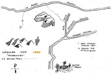
It appears that the Wagoner map is actually to his "Lost Wagoner Mine," as it is related to Miner's Needle, in the story on the The GeoZone Website. Oops! What's it doing in with the LDM maps?


treasm28 Wagoner 1890 -.jpg


It says his ore was rose quarts, too!
 

Dirty Dutchman

Sr. Member
Dec 27, 2010
324
72
Arizona
Detector(s) used
My Brain
Primary Interest:
All Treasure Hunting
EE,

Im sorry if it sound like i was being a smarta$$.

Yes i meant "Mexican Miners". But just because it wasnt Waltz i was talking about, doesnt mean it isnt just as interesting.

If you care to, do a little investigating on the internet and see if you can find out what seperates Mexican miners from other types of miners. They look for something in particular. It will blow your mind when you discover what it is, and you probably wont want to "blurt" it out either.

Our Geologists said there couldnt possibly be any gold in those Mountains. Obviously the Mexicans had a different opinion.

Just a "hint".....They STILL mine this way.

Thanks,
Travis
 

gollum

Gold Member
Jan 2, 2006
6,729
7,596
Arizona Vagrant
Detector(s) used
Minelab SD2200D (Modded)/ Whites GMT 24k / Fisher FX-3 / Fisher Gold Bug II / Fisher Gemini / Schiebel MIMID / Falcon MD-20
Primary Interest:
All Treasure Hunting
Dirty Dutchman said:
EE,

Im sorry if it sound like i was being a smarta$$.

Yes i meant "Mexican Miners". But just because it wasnt Waltz i was talking about, doesnt mean it isnt just as interesting.

If you care to, do a little investigating on the internet and see if you can find out what seperates Mexican miners from other types of miners. They look for something in particular. It will blow your mind when you discover what it is, and you probably wont want to "blurt" it out either.

Our Geologists said there couldnt possibly be any gold in those Mountains. Obviously the Mexicans had a different opinion.

Just a "hint".....They STILL mine this way.

Thanks,
Travis

Travis,

Are you talking about flashes?

If you look in the hardrock mining section of this forum, a year or two ago, I started a thread about that, and a little thing the Germans called "Witterung" The Brits called it "Blue Mist" at the Tin Mines.

If you spend any time at Rich Hill, you will meet an old timer that sets his old video camera on a tripod near dusk and lets it run until dark. He reviews the video and takes still shots from it when there are flashes. He has a photo album chock full (and they are mostly on the side of the hill where nobody looks). Go on that side of the hill and you will see two or three generations of barrel cacti next to each other in neat lines. That is how the Mexicans know where to look.

Best-Mike
 

Oroblanco

Gold Member
Jan 21, 2005
7,838
9,830
DAKOTA TERRITORY
Detector(s) used
Tesoro Lobo Supertraq, (95%) Garrett Scorpion (5%)
FEMF said:
<snip>

Hello Oro
I've been trying to find a direct connection between the Navajo's and the Superstition Mountains, and can't seem to find anything! Can you point me in the right direction again?
Thank's Again!
FEMF

I don't know of a direct, absolute proof of a Navajo presence there; however they did range considerably farther afield than the areas adjoining their reservation boundaries and were still conducting raids right up to 1900 as you can document in newspaper accounts. Mostly their raids were horse stealing, but murders also occurred. A clue that Weiser's attackers may have been Navajos is in the failure of the warriors to follow up the wounded man, as well as being armed with bows; Apaches were fairly well armed and more likely to be sure of killing their enemy.

<For an example of a Navajo raid occurring well after their surrender circa 1866, here is one article from 1883
http://chroniclingamerica.loc.gov/lccn/sn84021913/1885-06-06/ed-1/seq-3/;words=Navajo+raiding>

Navajos even were involved in an attack on Tucson, and took refuge in the Catalina mountains; this dates to the 1700's of course but is an indication of the fact they were able to range farther afield than is commonly supposed today.
Roy
 

FEMF

Full Member
Sep 10, 2009
158
86
Oro
Thanks again! I was thinking of a closer kind of tie, like a superstition type of connection? Just wondering
FEMF
 

OP
OP
EE THr

EE THr

Silver Member
Apr 21, 2008
3,979
38
Central California
DD & gollum---

On another topic, there was talk about the flashing stuff and also the gold weed (Desert Trumpet Plant), but the barrel cactus is a new one for me.

I've also seen it said that certain bushes and trees will turn unusual colors when near natural gold deposits.

Are any of these what you are talking about, Travis?

(I tried searching for Mexican prospecting techniques, and old Mexican prospectors, but had no luck.)
 

Oroblanco

Gold Member
Jan 21, 2005
7,838
9,830
DAKOTA TERRITORY
Detector(s) used
Tesoro Lobo Supertraq, (95%) Garrett Scorpion (5%)
FEMF said:
Oro
Thanks again! I was thinking of a closer kind of tie, like a superstition type of connection? Just wondering
FEMF

Actually I had not thought about that angle, thank YOU for the tip! I will be sending you a PM in a moment too.
Roy
 

OP
OP
EE THr

EE THr

Silver Member
Apr 21, 2008
3,979
38
Central California
Well, back to the Waltz era maps.

The Harmond map says to go North from just East of Weaver's Needle, over a saddle, to a spring with rocks piled high in it, look up, and it's within ten paces. That indicates the NE quadrant.

The two Walker & Wieser maps seem to say to go south from the river, and the mine is East of a major canyon. "Pinacle" is actually Superstition Peak. This again indicates the NE quadrant.

The second version "Wieser-Walker" map. Some people just can't draw a map. Jeez. This says, "The mine on Easterly shelf," and shows the Four Peaks. The Four Peaks don't look like that from any angle, so the mine must be on a shelf in the East Supers, and the alignment with Four peaks is attempted to be depicted. Globe is to the West, so the top, where the mine is shown, must be North. This, again, indicates the NE quadrant.

:coffee2:
 

Nov 8, 2004
14,582
11,942
Alamos,Sonora,Mexico
Primary Interest:
All Treasure Hunting
Morning EE, my friend: :coffee2: :coffee2: :coffee2: :coffee2: join Beth, Oro, with me? The Mulatto's is supposedly a sure sign of a silver deposit if in sufficient quantities. There are many others, especially their reference to the so called fires / luminous gas.

Don Jose de La Mancha
 

OP
OP
EE THr

EE THr

Silver Member
Apr 21, 2008
3,979
38
Central California
:coffee2: Gulp! Thank you. I needed that.

That's great news! My wife's a mulatto---I'm gonna go frisk her right now!

8)


Or were you referring to something else? :dontknow:

(No speaka de Spanish.)
 

Nov 8, 2004
14,582
11,942
Alamos,Sonora,Mexico
Primary Interest:
All Treasure Hunting
Evening EE: you posted-->---I'm gonna go frisk her right now!

************
Sheesh, it is a good thing that you are married to her. I'd hate to be the cause of your vocal range being elevated.

The mullatos referred to is a plant, not a Yellow Rose of Texas type.

Don Jose de La Mancha
 

Oroblanco

Gold Member
Jan 21, 2005
7,838
9,830
DAKOTA TERRITORY
Detector(s) used
Tesoro Lobo Supertraq, (95%) Garrett Scorpion (5%)
Don Jose are you referring to Epithelantha micromeris?
Epithelantha_micromeris_fr_810.jpg


Indicator plants are very often useful in searching for minerals that do not crop out on the surface, we ought not be surprised that Mexican prospectors knew which varieties to look for. Just for our readers who may not be posting, here is an online article which explains this much better than I can:
http://technology.infomine.com/articles/1/1650/indicator-plants.geobotany/indicator.plants.aspx

Muchas gracias mi compadre Don Jose' por la cafe! :thumbsup: :coffee2:

Oroblanco

:coffee2: :coffee: :coffee2:
 

Oroblanco

Gold Member
Jan 21, 2005
7,838
9,830
DAKOTA TERRITORY
Detector(s) used
Tesoro Lobo Supertraq, (95%) Garrett Scorpion (5%)
You are most welcome amigo, it is a branch of this business that I am still very much the learner. :read2:
 

OP
OP
EE THr

EE THr

Silver Member
Apr 21, 2008
3,979
38
Central California
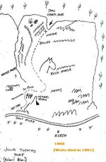
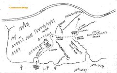
Next in the timeline, of the maps in the links above, is the Julia Thomas. And another, which appears to be copied from it, only with North and South reversed, and a bit more to scale.

Julia Thomas - Robert Blair Map 1892.jpg

Unknown.jpg

There is an interesting similarity between the depiction of the needle in the "Unnamed" map, and the heart stone from the "Peralta" Stones.

Heart Stone Needle.jpg


And again, the NE quadrant is indicated.

Another interesting thing is that Julia's map says, "ORE HERE," rather than, "MINE."

:coffee2:
 

OP
OP
EE THr

EE THr

Silver Member
Apr 21, 2008
3,979
38
Central California
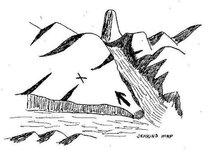
There are more coincidences and similarities with lots of these maps, but the problem is that it is impossible to get exact matches with them to the actual geography of the Supers.

treasm11 Jenkins Map.jpg

Match to treasm11 Jenkins Map.jpg


Or is it?


Note the position of the needle, and the position of the compass.

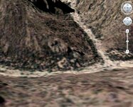
This Google shot is in the NE quadrant.

It would seem that whoever originally drew this map, was actually there, at the viewed-from spot, anyway. Of course, that doesn't mean that he put the X in the correct place. Or even that this is anywhere near the LDM.


:coffee2:
 

cactusjumper

Gold Member
Dec 10, 2005
7,754
5,388
Arizona
EE,

It would not surprise me if you went to the area of the X and found an old dig there. As I recall, Barry Storm had a location that he worked where he thought the ore came from. The Jim Hatt location of that X and Storm's are different if I remember correctly.

It turns out that a letter written by George Snell to Chuck Aylor describes a trip made by Storm, Jenkins and Snell......maybe another person as well, and the canyon that Jenkins led them to was not the one described in Storm's book.

Sounds like a perfect Storm-isim to me.


Match_to_treasm11_Jenkins_Map.jpg


Good luck,

Joe
 

Top Member Reactions

Users who are viewing this thread

Top