Lets look into LIDAR!

bedrock bubba

Sr. Member
Jun 27, 2010
446
396
I was watching Josh's treasure show on Tv, and he was in the Mayan jungle, and looked at LIDAR photos, and it removed all the forest and exposed the remains of a lost city! Really!

This seems like a valuable tool for finding gold to me! California mountains all have a lot of dense forest hiding ancient rivers, lodes and placers of every description. You can buy the photos, too! Does anyone have any experience with this, or knowledge?
 

Upvote 0

Goldwasher

Gold Member
May 26, 2009
6,077
13,225
Sailor Flat, Ca.
🥇 Banner finds
1
Detector(s) used
SDC2300, Gold Bug 2 Burlap, fish oil, .35 gallons of water per minute.
Primary Interest:
All Treasure Hunting
from what I've been told there is very little Lidar of the States available... especially in areas with trees..cause besides what the boob tube shows it actually doesn't punch through trees very well....
 

Kray Gelder

Gold Member
Feb 24, 2017
7,013
12,578
Georgetown, SC
Detector(s) used
Fisher F75
Primary Interest:
Metal Detecting
There is LIDAR coverage in some states. I think it's partially paid for by the states, so some have to justify the expenditures. Here in SC, they're working on it, but who knows when it will be available. I think it does penetrate forest coverage, from what I've seen. Bare Earth DEMS is another name for high resolution topo coverage. Try USGS, and individual state geographic or game departments. USFS doesn't provide it. Their maps are old school.

Some states do have it out there for public consumption, but you may have to purchase the software to download it. Good luck to you.
 

winners58

Bronze Member
Apr 4, 2013
1,729
4,058
Oregon
Primary Interest:
All Treasure Hunting
Lidar map viewer for Oregon, I choose the base map I like and check the "bare earth" in layers
There are downloadable Lidar data sets for many states through USGS or NOAA? but file storage at data.gov is down
the lidar data sets would need a GIS program that can view them, some are free most have licensing like Arcgis.

https://gis.dogami.oregon.gov/maps/lidarviewer/
 

Last edited:

ExcuseToHike

Tenderfoot
Dec 29, 2018
5
12
Central Washington
Detector(s) used
Minelab Go-Find 22
Primary Interest:
All Treasure Hunting
I was watching Josh's treasure show on Tv, and he was in the Mayan jungle, and looked at LIDAR photos, and it removed all the forest and exposed the remains of a lost city! Really!

This seems like a valuable tool for finding gold to me! California mountains all have a lot of dense forest hiding ancient rivers, lodes and placers of every description. You can buy the photos, too! Does anyone have any experience with this, or knowledge?

I had the same idea too and used the Washington state lidar maps to find a couple of cool spots. It is still tricky since in the mountains things can hide pretty easily.

Washington Lidar Portal
 

OreCart

Sr. Member
Jan 23, 2019
473
558
Maine
Primary Interest:
Prospecting
I am a farmer so I use LIDAR a lot for various things. I kind of cheat and go to my local USDA-NRCS office and have them do the mapping for me, but I having a map of my farm in 2 foot contours instead of 20 foot contours really helps highlight where water is moving or concentrating.

It has some limitations for sure, but my understanding is, LIDAR was done within 100 miles of the coast because of fear of the worlds oceans risings.

There is actually a free ebook out there for download called LIDAR for Dummies if anyone wants to try and find it. I did not find it super-useful, but I am just a dumb sheep farmer too.
 

Mgumby16

Full Member
Jun 26, 2014
204
326
East Coast
Primary Interest:
Prospecting
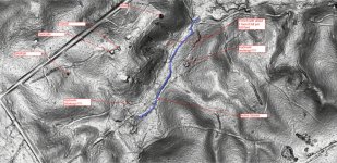
I use it all the time. The raw data is available for free for pretty much all of Virginia and NC. Some good data out there to for the Tahoe area of California including around the yuba and north fork of the American.

Below is a picture of lidar for one of the areas I'll be nugget shooting at soon. The area show has thick forest cover and the lidar does a great job of seeing right through it.
 

Attachments

  • 1548445149693.jpg
    1548445149693.jpg
    124.5 KB · Views: 137

Oddjob

Silver Member
Aug 23, 2012
4,348
9,067
Detector(s) used
RD1000, GSSI Profiler EMP-400. GPZ 14 & 19
Primary Interest:
Other
YOu could check on the NGA website under their product page list several great resources for GEOINT.
 

Blazer11

Greenie
Feb 26, 2019
19
36
Central Florida
Detector(s) used
Bounty Hunter Land Ranger pro
Primary Interest:
All Treasure Hunting
I am a farmer so I use LIDAR a lot for various things. I kind of cheat and go to my local USDA-NRCS office and have them do the mapping for me, but I having a map of my farm in 2 foot contours instead of 20 foot contours really helps highlight where water is moving or concentrating.

It has some limitations for sure, but my understanding is, LIDAR was done within 100 miles of the coast because of fear of the worlds oceans risings.

There is actually a free ebook out there for download called LIDAR for Dummies if anyone wants to try and find it. I did not find it super-useful, but I am just a dumb sheep farmer too.

I think this is the book you may have been talking about. I posted the link below.


https://ibis.geog.ubc.ca/courses/geog373/lectures/Handouts/LiDARforDummies.pdf
 

Top Member Reactions

Users who are viewing this thread

Top