tomw
Tenderfoot
I’m going to break Silence and Taboo all in one shoot here. First let me introduce myself I’m a 43yr male from the Foley area (lower Baldwin county al) I work six and seven days a week just to make ends meet. I am also a Diver and fascinated with our county History.
For a few years now I have been chasing a lot of dead end leads on a few of our relics of the past. First being the Whiskey Wreck or Mail Barge as some call it and not to far down the beach just west lays the Paddle-wheeler My main interest of the wrecks. NOAA calls it the Miami but History books put this blockade runner sunk many hundreds of miles away. I do love the Civil War.
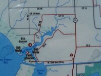
All this being said brings me to the Subject of what would be Taboo from some of my Silverhills friends. Discussing MD sites. My area of interest is in the Bon Secour area Camp Anderson and the Salt works. History tells us Camp Anderson was placed the to help guard the Works from evading Forces. I understand the Works was just inside the Bon Secour bay on the North side and across the bay to the South lays another with Camp Anderson in the middle. Now not far down the Bat towards the Fort is Navy Cove A Brigade landed here and traveled around the Eastern Shore just to the east of once again Bon Secour and as many may know there has always been plenty of underbrush and swamps to deal with in the area..
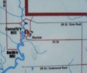
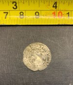
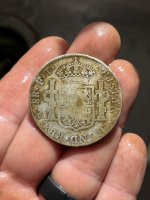
Which bring me to my point. History of the area has said there was only one road into Bon Secour and one way out. This path is the one I’m trying to find. Somewhere has to lay a road or path that connects Camp Anderson with the Pickets on the moth of Fish River and on up to Fort Blakely. I did find a field just off County rd 32 close to Fish River where in just a short time and only working the backside of the field yielded several bullets and button backs. As soon as the Farmer works this field up I’m planning on spending a day there.
I know it is a long shot asking this, but can anyone hlp me out with any information on the above?
Tom
For a few years now I have been chasing a lot of dead end leads on a few of our relics of the past. First being the Whiskey Wreck or Mail Barge as some call it and not to far down the beach just west lays the Paddle-wheeler My main interest of the wrecks. NOAA calls it the Miami but History books put this blockade runner sunk many hundreds of miles away. I do love the Civil War.
All this being said brings me to the Subject of what would be Taboo from some of my Silverhills friends. Discussing MD sites. My area of interest is in the Bon Secour area Camp Anderson and the Salt works. History tells us Camp Anderson was placed the to help guard the Works from evading Forces. I understand the Works was just inside the Bon Secour bay on the North side and across the bay to the South lays another with Camp Anderson in the middle. Now not far down the Bat towards the Fort is Navy Cove A Brigade landed here and traveled around the Eastern Shore just to the east of once again Bon Secour and as many may know there has always been plenty of underbrush and swamps to deal with in the area..
Which bring me to my point. History of the area has said there was only one road into Bon Secour and one way out. This path is the one I’m trying to find. Somewhere has to lay a road or path that connects Camp Anderson with the Pickets on the moth of Fish River and on up to Fort Blakely. I did find a field just off County rd 32 close to Fish River where in just a short time and only working the backside of the field yielded several bullets and button backs. As soon as the Farmer works this field up I’m planning on spending a day there.
I know it is a long shot asking this, but can anyone hlp me out with any information on the above?
Tom