- Jun 27, 2004
- 511
- 905
Mdog, I got something here that might blow you away...lemme look and debate whether I want to post it here or send it to you
Sounds good.Mdog, I got something here that might blow you away...lemme look and debate whether I want to post it here or send it to you
To All,View attachment 2144193
Photo from Google Maps (photo vantage point near Purgatoire Campground) .. pretty sure it's the same spot shown in this photo below (taken from The Travels of Hardrock Hendricks by Faye Hendricks, RAM 1976) View attachment 2144194
Very interesting..To All,
I have an older friend who punched in a road with a D-6 Cat into this area in the early 1960’s. The place in question was a cattle camp by one of the local ranching families that are still large land holders in that part of the country. He has lived in the area for nearly 90 years.
I’ve been picking his brain and he is a wealth of knowledge when it comes to this and other areas.
Regards
LUE-Hawn
What is "real" and what is not? Here are some "treasure signs" that were created in quite recent times, scattered among much, much older markers in a well known repository of historical information. I know they're new because many years ago I photographed the "genuine" carvings and as I returned numerous times since, I began noticing the new stuff. By the way, this chicanery works both ways. In the same area, back in the 1970s, in the same area, I found a clearly older weathered carving that said "ADAMS 1880". Years later, it had been totally destroyed. Here are the "new" carvings:Thanks for the post, Randy. There is so much information about treasure signs and symbols that you could go into the sticks, on a long weekend and create a cache site, just to mess with people. If you find markers in the field. the most important thing you have to do is figure out why they were put there. If somebody is creating treasure signs, it makes it that much harder to do your research.
. . .
Mdog, someone else was moving in the same line of thinking as you were many years ago.Sounds good.
dog, you can probably print the LUE map with an inkjet printer onto clear acetate sheets to overlay on paper maps. That way, you can print different scaled base maps from Google Earth Pro and manually rotate the overlay.. . . I traced them on a piece of wax paper, the stuff my wife always tells me to stay out of. . . .
Future treasure seekers won't be able to tell the difference between the genuine markers and the new stuff. Soon, more and more people won't even waste their time in the field looking for treasure sign.What is "real" and what is not? Here are some "treasure signs" that were created in quite recent times, scattered among much, much older markers in a well known repository of historical information. I know they're new because many years ago I photographed the "genuine" carvings and as I returned numerous times since, I began noticing the new stuff. By the way, this chicanery works both ways. In the same area, back in the 1970s, in the same area, I found a clearly older weathered carving that said "ADAMS 1880". Years later, it had been totally destroyed. Here are the "new" carvings:
View attachment 2144386
View attachment 2144387
View attachment 2144388
View attachment 2144389
Thanks for sharing that information, Randy. I'll check the areas that you have circled and see if I can find anything that would indicate coordinates or a specific area. I will still need the Kensington Runestone mapping and the star chart. Right off, the dot at the top of the triangle in the bottom right quadrant is at the Kensington Runestone site. I have often wondered if there might have been a cache close to the runestone or something else of importance.Mdog, someone else was moving in the same line of thinking as you were many years ago.
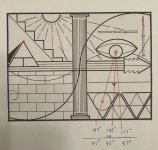
I bought a packet of materials belonging to a father and son who had worked in tandem with Larry Goddard on the LUE in the 1970s. Among other things was a LUE version and some notes, indicating their belief at the time in 7 separate cache sites. They based their theory on the presence of several markers on the map, most notably the two dots in the original maps you've already marked, and 5 other "notches" scattered around the map. These are much more clear on cleaner versions of the map, but I've circled all 7 spots for your consideration...
Thanks, Randy. Yes, the "cryptic shibboleth hoarde of all hoardes", got me too. I've read countless hours, during my life, and he's the only author that I've seen use that word. I didn't even know what it meant until I looked it up this morning. Seems to mean a password. One thing I liked about Von Mueller's writing was that it was easy to understand. That phrase did seem out of place.This is perhaps the cleanest copy of the LUE I have. Unfortuantely, it came out of THM& from RAM publishing, so it's missing the two dots. RAM was notorious for using awful binding, so their spines crack over time. In this case, the LUE map fell out of my copy so I was able to make a very clean copy that was also free of distortion that photocopying straight from the book would have resulted in due to curvature in the spine.
The "notches" are mch easier to make out in this version. I also include the original captioning of the map because I feel there are some clues to the map containedtherein. KvM used some odd word choices, particularly if you're read nearly as much of his stuff as I have. Writing is like a fingerprint, everything from word choice, to spelling errors, to sentence length, etc. To put it bluntly, I don't know that I ever otherwise saw Karl use a phrase like "cryptic shibboleth hoarde of all hoardes"
View attachment 2144409
Thanks sdcfia. I'm a tech idiot but I'm going to try working my way through these instructions. I'm sure this program will be a lot better than what I'm doing.dog, you can probably print the LUE map with an inkjet printer onto clear acetate sheets to overlay on paper maps. That way, you can print different scaled base maps from Google Earth Pro and manually rotate the overlay.
Also, even better, you can download a graphics program (I use the free Photoscape X) that lets you load a Google Earth Pro jpg or screenshot as a base image, then insert a second image (LUE map) on top of the first one, lower the LUE map opacity so you can see through it, scale it, rotate it, reverse it, etc. A little more work, but your wife will be happy.
The best suggestion I've ever gotten is that IAYAYAM stands for "I Am You And You Are Me." I've taken this to mean that perhaps the map is meant to be read as a mirror image. Your guess is as good as mine though.Thanks, Randy. Yes, the "cryptic shibboleth hoarde of all hoardes", got me too. I've read countless hours, during my life, and he's the only author that I've seen use that word. I didn't even know what it meant until I looked it up this morning. Seems to mean a password. One thing I liked about Von Mueller's writing was that it was easy to understand. That phrase did seem out of place.
I know some of you have exchanged ideas about the IAYAYAM key, but if he said that the LUE clue was redrawn exactly from the IAYAYAM key, does that mean that the LUE clue is the whole key or are there more parts to the key?
I also include the original captioning of the map because I feel there are some clues to the map containedtherein. KvM used some odd word choices, particularly if you're read nearly as much of his stuff as I have. Writing is like a fingerprint, everything from word choice, to spelling errors, to sentence length, etc. To put it bluntly, I don't know that I ever otherwise saw Karl use a phrase like "cryptic shibboleth hoarde of all hoardes"
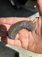
The last photo is very interesting. 🧐 Will you tell us more about what happened there ?What is "real" and what is not? Here are some "treasure signs" that were created in quite recent times, scattered among much, much older markers in a well known repository of historical information. I know they're new because many years ago I photographed the "genuine" carvings and as I returned numerous times since, I began noticing the new stuff. By the way, this chicanery works both ways. In the same area, back in the 1970s, in the same area, I found a clearly older weathered carving that said "ADAMS 1880". Years later, it had been totally destroyed. Here are the "new" carvings:
View attachment 2144386
View attachment 2144387
View attachment 2144388
View attachment 2144389
Perhaps not...since that's literally the entire content for its original publication. It's slipped into the picture section of the book almost as an afterthought. There would be no back story or discussion about the map for several more years when he published NPG 6.2, and then more a few later in Treasure of the Valley of Secrets. You are right about his thoughts on "Big Tickets" though, he was much more focused on finding lots of small treasures closer to home.At the risk of stating the obvious, KVM wrote a sensational description; he's literally advertising a treasure hunt and puzzle challenge. That's interesting because he advised caution against "Big Ticket" treasures yet he's selling the heck out of this one.
I discovered it several years ago while searching for the weathered missing "ADAMS 1880" carving. Those are my gloves in the photo for scale. It appears to be a niche of some sort. Even though the rock is a relatively soft volcanic tuff, it took a significant amount of work to accomplish. I have no idea who did it.The last photo is very interesting. 🧐 Will you tell us more about what happened there ?
I checked these notches that you circled, in the upper right quadrant, and I believe they were used, with the star chart, to determine coordinates. It does seem they used 1/16 of an inch, on the LUE clue, to represent different units of measure, feet, miles and degrees.Mdog, someone else was moving in the same line of thinking as you were many years ago.
I bought a packet of materials belonging to a father and son who had worked in tandem with Larry Goddard on the LUE in the 1970s. Among other things was a LUE version and some notes, indicating their belief at the time in 7 separate cache sites. They based their theory on the presence of several markers on the map, most notably the two dots in the original maps you've already marked, and 5 other "notches" scattered around the map. These are much more clear on cleaner versions of the map, but I've circled all 7 spots for your consideration...