- Jun 27, 2004
- 515
- 911
A poster named Nobody, not sure if he's still around, but he posted this some 8 or 9 years back...it's what really got me thinking about the sunrays and how they might be used on an overlay...

Thank you, Randy.This is pretty awesome...
I'll need to consult my old powerpoint from the presentation I did, I had someone on the forums suggest a similar use of the sun rays...but measuring as you have certainly provides an intriguing possibility.
I've often wondered, assuming the reported recovery sites were legit, if there would be a way to reverse engineer the map to ultimately reveal additional locations. that said, seems even if you could, reported locations (assuming they're legit) might not be very useful from a proximity standpoint. Most of the locations (Mora, Elizabethtown, etc.) refer to towns in the area with no sense of how much distance might truly exist between the towns (as reference points) and the actual cache recovery sites.
None of your maps dip into the NM area where many of the alleged recoveries occur.
Something else to consider, I'm fairly certain Pyramid Peak in southern Colorado, which has a rather pronounced notch in the adjoining peak, is likely an aspect of solving the LUE as well.
Outstanding post sir...
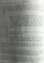
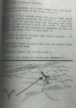
Read it backwards MAYAYAI Remember a capital M is the same as a capital W. A means ”To”. Y means a Fork. Look at Charles Kenworthy’s book on the Lost Dutchman Mine it talks about the meaning in detail.The best suggestion I've ever gotten is that IAYAYAM stands for "I Am You And You Are Me." I've taken this to mean that perhaps the map is meant to be read as a mirror image. Your guess is as good as mine though.
A little off topic here, but does anyone know the whereabouts of "Nobody"? Real name is Christopher Fox. Unfortunately, he removed almost all his posts back when he left TNet. He was perhaps the most intriguing and, at times provocative participant here.A poster named Nobody, not sure if he's still around, but he posted this some 8 or 9 years back...it's what really got me thinking about the sunrays and how they might be used on an overlay...
. . .
Dunno but if his posts went, it likely means he got banned...last time I checked you couldn't delete your own posts or even edit them after a certain time period.A little off topic here, but does anyone know the whereabouts of "Nobody"? Real name is Christopher Fox. Unfortunately, he removed almost all his posts back when he left TNet. He was perhaps the most intriguing and, at times provocative participant here.
I always looked forward to his posts and he shared a lot of research. I was sorry that he left and I don't know his whereabouts.A little off topic here, but does anyone know the whereabouts of "Nobody"? Real name is Christopher Fox. Unfortunately, he removed almost all his posts back when he left TNet. He was perhaps the most intriguing and, at times provocative participant here.
That was a good post with some great pictures. Thank you.Hello All,
A note to remember* The Spanish would not make a map that would lead you directly to a treasure site. The same goes with the outlaws they used the (lay of the land) neither had computers or GPS. They used as I have said before “Common Sense”.
There are plenty of signs most are directional indicators as to what to follow to get back home and generally look south.
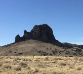
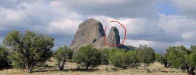
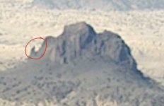
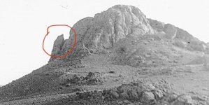
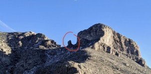
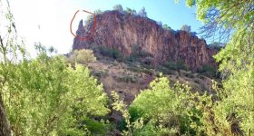
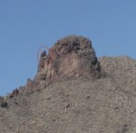
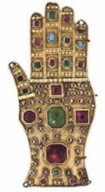
In regard to treasure sites, the Spanish placed as Charles Kenworthy would say “Eye Catchers” that could be seen from long distances such as Hoyos, Dolmans, White faced rocks or in many cases “Hand Of God” sites whereas there would be a rock monolith that contained a thumb style rock next to the main body of the rock feature. Such as Victorio Peak it is what was called a Hand of God site. These sites are not just coincidental in shape and form. They were meant to convey a message as to look here.
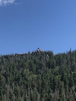
I will attach some noted sites that have treasure associated with them that are scattered throughout the Southwest. They are active sites but I have not the time or energy to visit each although I know several who are actively searching.
Bests in Treasure
LUE-Hawn
Hello MD,That was a good post with some great pictures. Thank you.
Are these geological formations that were used as convenient landmarks along a trail...is that right? Are some of these small enough that they could have been created by Spanish engineers?
I've never commented on the lower left quadrant of the LUE clue but I've heard others say that the rectangles represented gold bars and the number of bars represented caches.I've never commented on the lower left quadrant of the LUE clue but I've heard others say that the rectangles represented gold bars and the number of bars represented caches.
Here's something to consider for those of you who study the LUE clue. Perhaps the rectangles indicate masonry and the number of bricks will lead you to a specific lodge.
The coordinates of 38deg N and 105deg W, near Pueblo Mountain Park, takes you to a specific area in Colorado. After you get to that place, where do you go next? Because I believe that the LUE clue was created by Masons, it makes sense to look for the Masonic lodges in the area. The lodges are numbered so the LUE clue and the bricks in the lower left quadrant could lead you to the correct lodge. As an example, their are 24 bricks in the wall but only 15 of them are whole. Mount Moriah Lodge #15 is at Canon City about 30 miles to the north.
View attachment 2145177
Nope, he is a rancher who has lived in the area for nearly 90 years. No Nazi connections whatsoever.Very interesting..
does he have anything to say about the highgrading conspiracy that our Crow found ?

"The Lue Map and the Nazi Connection -3"
Some interesting stuff. ironic with such conspiracy stories. there was a lot of ill feeling in 1890s with many banks failure taking peoples life savings and government of day saved and bailed out the top end of town with the average poor who lost money from banking collapses getting the short...www.treasurenet.com
Hello All,To All,
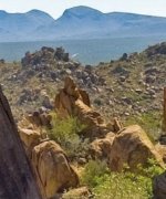
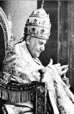
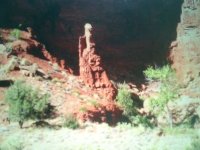
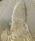
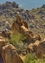
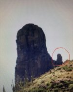
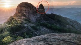
This is a little off topic. But I want to ask you if you see what I see in regard to rock monuments. In particular. Knowing that the Early Spanish had a keen reverence for the King of Spain and The Pope they left rock monuments to reflect those two entities, Let me know if you can see what I see?
In one I can see the Pope sitting on his throne and as most revered people most Spanish thought the Pope was rather portly (Fat) which was considered a sign of wealth and this rock feature portrays it . I also included a screenshot with the Pope with a miter hat it was a cone shaped hat that came to a point. Both the rock feature and the Pope on his throne have a cone shaped miter hat.
The second Rock feature is of the King of Spain sculpted in Red Rock. What I see is the King sitting on his throne with a sceptre in his right hand. With his crown or hat in what was considered period clothing with the puffy britches..
Please note* The Spanish had sign makers or sculptors with them to help others who came after them to find the way back, to view particular item or perhaps a spot of wealth. The thing to do was to look in the direction, the sculpted stone monument was looking to determine what it the stone monument was looking at?
Remember always take a compass reading if you happen to find anything that matches what you believe is a stone monument that could possibly be a sculpted figure?
These are only two that I am including here. The Spanish, Jesuits and the Franciscans were a crafty if not devious group of people. They left monuments for others to follow but they made them in such a way that they were not obvious as to determine the way to go or to see what they were seeing.
Just as maps show the way, but you have to determine what they were trying to say and you had to know how to read it correctly.
Some famous maps include the LUE Map, The Molina Map, the Spider Rocks, the Peralta Stones, the Star Map and the so called Wolf Map all which have been deciphered to some point.
I hope this helps?
Bests in Treasures
LUE-Hawn
Hello All,Read it backwards MAYAYAI Remember a capital M is the same as a capital W. A means ”To”. Y means a Fork. Look at Charles Kenworthy’s book on the Lost Dutchman Mine it talks about the meaning in detail.
Regards
LUE-Hawn