Gypsy Heart
Gold Member
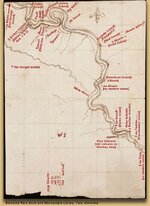
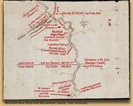
In 1795 Spanish merchants in St. Louis had sent James Mackay and John Evans on a trading expedition up the Missouri River with instructions to find a route to the Pacific Ocean. Between 1795 and their return in 1797 they produced a set of maps (Figs. 2, 3, 4) that charted the river from its mouth to the Mandan villages, and that gave names for all of its principal tributaries. French voyageurs almost certainly had given the explorers the names they’d attached to these streams — names that, for the most part, they still bear.
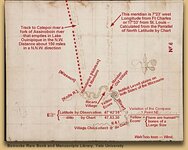
The maps laid out in detail the first full year of the Lewis and Clark expedition and were important planning documents for the Captains
This section of the Mackay/Evans map extends from the island at lower right called "au Vase" — now submerged beneath Lake Francis Case, the reservoir behind Fort Randall Dam in southeastern South Dakota — to "I au Biche," which the Corps of Disovery may have reached on about September 24, 1804.