Curtis, E.C., PM, i can receive messages. will not send, leave e-mail in pm, have some info on carvings.
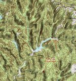
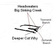
i never use signs or symbols from a book or any where because every group is different. the turkey track in this case is to identify important parts of the lower devils creek map. the upper part of big sinking creek is part of the key. showing cave branch and the birds head. the head waters of big sinking is where the three forks are located. the reason the map shows the middle toe shorter is that townsend branch is shorter. big sinking and zackariah are the longer of the three. on the map it shows big sinking and zackariah deeper cut then the others. but that could be to mislead others and one of the other Branch's is the real location. the other knot in the wood is that zackariah has three Branch's. i showed where cave branch ends vary close to the three forks. it may take a lot of foot work and more carvings to figure this out. the carving of the bird. that bird rock needs to be gone over vary carefully and the area around it. click map to enlarge.
i never use signs or symbols from a book or any where because every group is different. the turkey track in this case is to identify important parts of the lower devils creek map. the upper part of big sinking creek is part of the key. showing cave branch and the birds head. the head waters of big sinking is where the three forks are located. the reason the map shows the middle toe shorter is that townsend branch is shorter. big sinking and zackariah are the longer of the three. on the map it shows big sinking and zackariah deeper cut then the others. but that could be to mislead others and one of the other Branch's is the real location. the other knot in the wood is that zackariah has three Branch's. i showed where cave branch ends vary close to the three forks. it may take a lot of foot work and more carvings to figure this out. the carving of the bird. that bird rock needs to be gone over vary carefully and the area around it. click map to enlarge.