davidbakhtar
Jr. Member
- Jun 28, 2007
- 26
- 0
Info on latest gen in underground and marine sub-bottom profiling. Anybody with a serious project is welcome to contact me.
BakhtarRadar: A new dimension in GPR - Non-Invasive Exploration and Sub-Surface Imaging
BakhtarRadar represents a new generation in GPR. Originally developed by Dr. Khosrow Bakhtar under the U.S. Air Force Small Business Innovative Research (SBIR) program to detect buried ordnance, it is now available for civil applications for the first time.
Using a newly invented principle called "Forced Resonance," BakhtarRadar (previously known as Earth Radar) offers much higher resolution and enhanced signal-to-noise ratio (SNR), facilitating ease of analysis and discrimination as compared to conventional GPR-- and in 4D.
Ground application:
Depth of penetration is up to, and even exceeding, 600 ft. (depending on antenna design). There are no limitations with respect to soils, lithology or degree of saturation of the geologic materials.
BakhtarRadar uses a ground-based system in which the antennae are pulled via a small tractor. The ground surface should therefore permit the tractor to negotiate the surface and corners. Ground interrogation is triggered with a high resolution Global Positioning System (GPS), allowing transfer of the location coordinates onto any GIS system for site planning.
In most cases, BakhtarRadar can separate and discriminate sub-surface lines if separated vertically or horizontally. Underground utility lines are best detected and discriminated if they don't cross and their vertical and horizontal separation distance is more than a few inches.
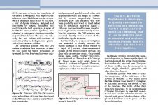
A ground demo image is attached. Note, the jagged appearance was from using temporary nylon ties to hold antennae during demo. This is resolved with rigid ties for ground applications and a stabilizer used in marine film production for water apps.
The technology is available through a service contract.
Marine application:
BakhtarRadar’s principal marine applications are shipwreck detection and sub-seabed mapping/volumetric imaging of the submerged target. It can detect metallic and non-metallic targets. In most cases, BakhtarRadar can reconstruct 4-dimensional and volumetric images to better discriminate between the target and ocean floor clutter. It offers higher resolution in the MHz regime and an enhanced signal-to-noise ratio (SNR), facilitating ease of analysis and discrimination as compared to conventional systems.
Depth of penetration is up to 300 ft. of water and seabed (depending on antenna design and size of the submerged target). There are no limitations with respect to salinity, sand depth, soils or overburden.
The device is mounted on zodiacs, which are towed by the mother ship. The ship covers the search area in a zigzag pattern, then goes back over anomalies very slowly.
Seabed interrogation is triggered with a high resolution Global Positioning System (GPS), allowing transfer of the location coordinates onto any GIS system for site planning.
The technology is available through a service contract.
For more information, please contact:
David Steinman
Bakhtar Associates
PO Box 494
Bronxville, NY 10708-0494,
U. S. A.
(914) 237- 6533
email: [email protected]
BakhtarRadar: A new dimension in GPR - Non-Invasive Exploration and Sub-Surface Imaging
BakhtarRadar represents a new generation in GPR. Originally developed by Dr. Khosrow Bakhtar under the U.S. Air Force Small Business Innovative Research (SBIR) program to detect buried ordnance, it is now available for civil applications for the first time.
Using a newly invented principle called "Forced Resonance," BakhtarRadar (previously known as Earth Radar) offers much higher resolution and enhanced signal-to-noise ratio (SNR), facilitating ease of analysis and discrimination as compared to conventional GPR-- and in 4D.
Ground application:
Depth of penetration is up to, and even exceeding, 600 ft. (depending on antenna design). There are no limitations with respect to soils, lithology or degree of saturation of the geologic materials.
BakhtarRadar uses a ground-based system in which the antennae are pulled via a small tractor. The ground surface should therefore permit the tractor to negotiate the surface and corners. Ground interrogation is triggered with a high resolution Global Positioning System (GPS), allowing transfer of the location coordinates onto any GIS system for site planning.
In most cases, BakhtarRadar can separate and discriminate sub-surface lines if separated vertically or horizontally. Underground utility lines are best detected and discriminated if they don't cross and their vertical and horizontal separation distance is more than a few inches.
A ground demo image is attached. Note, the jagged appearance was from using temporary nylon ties to hold antennae during demo. This is resolved with rigid ties for ground applications and a stabilizer used in marine film production for water apps.
The technology is available through a service contract.
Marine application:
BakhtarRadar’s principal marine applications are shipwreck detection and sub-seabed mapping/volumetric imaging of the submerged target. It can detect metallic and non-metallic targets. In most cases, BakhtarRadar can reconstruct 4-dimensional and volumetric images to better discriminate between the target and ocean floor clutter. It offers higher resolution in the MHz regime and an enhanced signal-to-noise ratio (SNR), facilitating ease of analysis and discrimination as compared to conventional systems.
Depth of penetration is up to 300 ft. of water and seabed (depending on antenna design and size of the submerged target). There are no limitations with respect to salinity, sand depth, soils or overburden.
The device is mounted on zodiacs, which are towed by the mother ship. The ship covers the search area in a zigzag pattern, then goes back over anomalies very slowly.
Seabed interrogation is triggered with a high resolution Global Positioning System (GPS), allowing transfer of the location coordinates onto any GIS system for site planning.
The technology is available through a service contract.
For more information, please contact:
David Steinman
Bakhtar Associates
PO Box 494
Bronxville, NY 10708-0494,
U. S. A.
(914) 237- 6533
email: [email protected]