Oak Island the Strange, the Bizarre, and Maybe the "Truth!

Readyman

Tenderfoot
Mar 3, 2021
5
2
Primary Interest:
All Treasure Hunting
What has preceded could be mere happenstance, but the suggested ground plan does receive potential support from another direction. The point is, just how likely is it that this could happen should the ground plan be pure conjecture and should the data it’s being matched to be pure fiction.

What might be the odds against this happening, that is, finding order when applying claimed fictional directions to an equally fictional ground plan? Sensibly, it just shouldn’t happen.

In this, I would simply ask the reader to suspend disbelief and assess what is being presented in a truly objective manner. By all means bear in mind that the ground plan may not be what the originator drew up and that the directions employed could have been fabricated, but ask yourself how on earth the result of the process described could be achieved were this so.

Assume that you need to identify locations on the ground by reference to five ground markers positioned using a dreamed up geometrical schema. The five points could be anywhere on a plot of land 420 feet by 480 feet. Put them wherever you want.

Now, conjure up five sets of instructions out of thin air employing between five and eight random numbers with the same number of random bearings as offsets from three of the five points on the ground. Then, draw a figure on the ground and interpreting the instructions in the same way make them end up positioned equally-spaced on that figure.

What’s the likelihood that you could achieve that in one go and would you reasonably expect that to happen? What’s the likelihood that you could do it in a thousand goes? I suggest that your winning the lottery, should you enter, would be far more likely. Bear in mind that everything is random because the entire basis is fictional.

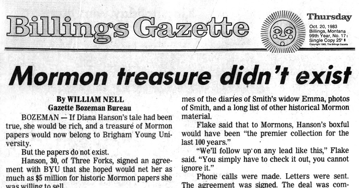
That’s what many might consider we have on Oak Island. I’ve drawn up what many would consider a fictional ground plan and now I intend to apply five sets of widely-assumed fictional instructions to it. The aim is to match these to five out of seven equally-spaced points on the Rhombus Rectangle that emerged quite naturally and geometrically from the ground plan I developed based on the placing of the ground markers on Oak Island.

Of course, the directions I’m talking about are the instructions on five much-derided treasure maps - and note well only the instructions, not the outline of the island. I’ve previously observed that these instructions when interpreted in exactly the same way using the ground plan developed in the preceding posts lead to five of the seven points marked on the Rhombus Rectangle.

I’m amazed that this could happen by sheer accident, but it seems that I’m the only person who is! I assume that this is because people have decided that they don’t believe in treasure maps. Treasure hunters who don’t concede the possibility of there having been treasure maps? Could it be?

I’ve noted that it seems that clues are being intentionally left by the originator, and there’s a clue to the working of the instructions provided on one of the maps. The text reads, “from centre of triangle between Rocks,” followed by a distance (20 feet) and a bearing (East). This actually leads to the point on the Rhombus designated 'F' and is short of target by just 7 inches.

However, this immediately opens up the remaining sets of instructions. They all work in the same way:

Identify three points by distance and bearing from the ground markers identified: the drilled rocks, triangle or Tree (Money Pit). Form a triangle and find its centre (by median). Then take an offset as specified in the direction of the Rock Centre Point unless stated otherwise. Should a unit be specified in the offset on the last line in the form “a by b by c” then resolve this as “a + b + ac”.

This is why “3 feet by 3 feet by FOUR” resolves to 18 feet, “7 feet by 7 feet by 8" is 70 feet and “5 feet by 4 feet by 5" is 34 feet.

So, the instructions given in an earlier post would read: From a point on the Roadway at the west of the island go 515 fathoms southeast (to the Welling Triangle) and then 50 fathoms north (to the Tree, or Money Pit) and then 36 fathoms in the direction of the East Rock which is then 36 fathoms from this spot. Form a triangle with the two rocks and find its centre and continue 18 feet (north) from there. The end point is a mere five inches short of the target (the Rhombus point designated 'D').

That this could be done once with purely random distances and random bearings from a fictional map based on a fictional ground plan is surprising to me, but to be able to do it five times is almost unbelievable.

Unfortunately, the maps have not been well received and there’s a tendency to write off the instructions along with the outline of the island and the pieces of paper. These may well be copies of copies of copies, and the island outline looks little like Oak Island, but this should have no bearing on the validity or application of the instructions.

I fully appreciate that if you’ve decided the treasure is in the Money Pit and you desperately want the originator to be Templar then this is not for you.
Templars indeed.
The same divinely dedicated and constructive group that sacked the Holy Land of antiquities/treasures. Built and engineered structures, fortresses, castles and churches across Europe all the way to the Holy Land. When outlawed there would be no shortage of Templar volunteers with the requisite skills to travel to the end of the earth(at that time) and work on this 'final crusade'.
Treasure?, Antiquities?, Pestilence?, Pure Evil? Whatever it is , it was never meant to be found, the Templars knew the game was over for them.
The carved rocks on Oak Island were the "Kilroy Was Here" graffiti of the era, the "off hour" activities of the talented work crew. Lining up large rocks might have even been the effort of a few subversives to geo-locate the shaft when they returned at a later time. If the Templars didn't 'off' them after the project... for sure death awaited everyone upon return to Europe anyway.
Gold, brass, bronze & metals in the water sounds interesting no matter what it is.
 

joska

Full Member
Nov 21, 2012
182
85
Primary Interest:
All Treasure Hunting
Okay people way too much time spent on what if speculating.if there is any amount of gold there ,I can show the guys in just a few minutes where exactly it is.But honestly it’s all about the show and not about real treasure hunting.I will do it for free.
 

gjb

Full Member
Apr 21, 2016
240
307
UK
Detector(s) used
Garrett Ace 300i
Garrett EuroAce
Primary Interest:
All Treasure Hunting
Whatever it is , it was never meant to be found, the Templars knew the game was over for them.
Why would a treasure be buried never to be recovered? Would the Templars really just have given up like that?

I’ve pondered on why a treasure might have been deposited and not retrieved by the depositor. It seems to me that a treasure that might assist in a later resurgence could fit that scenario, and the Templars would seem like prime candidates.

A Templar treasure could simply have been stored until the time was right to recover and use it. Maybe no opportunity arose, or those who knew of it simply died without disclosing either its existence or its whereabouts.
 

Readyman

Tenderfoot
Mar 3, 2021
5
2
Primary Interest:
All Treasure Hunting
Why would a treasure be buried never to be recovered? Would the Templars really just have given up like that?

I’ve pondered on why a treasure might have been deposited and not retrieved by the depositor. It seems to me that a treasure that might assist in a later resurgence could fit that scenario, and the Templars would seem like prime candidates.

A Templar treasure could simply have been stored until the time was right to recover and use it. Maybe no opportunity arose, or those who knew of it simply died without disclosing either its existence or its whereabouts.
The Templars were outlawed and put to death in Europe, the burial of 'something' on OI was the end game for them. When this group returned to Europe they'd be put to death too- there will be nobody to come back and dig it up. So no need for landmarks.

The metal assays indicated various OI non-indiginous metals, could be anything down there. In our current era we all think $$$ is everything, gold, silver, gems! The Templars may have been working with other (more divine) motives, and what was buried at the end of the world(to be lost to mankind forever) might have changed the world forever(and still could!), or be a worthless figurine adored/valued only by the Templars.
 

gjb

Full Member
Apr 21, 2016
240
307
UK
Detector(s) used
Garrett Ace 300i
Garrett EuroAce
Primary Interest:
All Treasure Hunting
The Templars were outlawed and put to death in Europe, the burial of 'something' on OI was the end game for them. When this group returned to Europe they'd be put to death too- there will be nobody to come back and dig it up. So no need for landmarks.
The Templars weren't persecuted elsewhere in Europe as much as in France. England was a case in point. Some 'recanted' and some joined other orders, so they could simply have gone underground.

Furthermore, whatever they buried on Oak Island could much more simply have been dropped into the sea in the middle of the Atlantic from where it couldn't possibly have been recovered. Burying it would be a risk, still leaving an opportunity for its being unearthed. Maybe that was the point.
 

Readyman

Tenderfoot
Mar 3, 2021
5
2
Primary Interest:
All Treasure Hunting
in France. England was a case in point. Some 'recanted' and some joined other orders, so they could simply have gone underground.

The Templars weren't persecuted elsewhere in Europe as much as in France. England was a case in point. Some 'recanted' and some joined other orders, so they could simply have gone underground.

Furthermore, whatever they buried on Oak Island could much more simply have been dropped into the sea in the middle of the Atlantic from where it couldn't possibly have been recovered. Burying it would be a risk, still leaving an opportunity for its being unearthed. Maybe that was the point.
Agreed
 

Charlie P. (NY)

Gold Member
Feb 3, 2006
13,004
17,108
South Central Upstate NY in the foothills of the h
Detector(s) used
Minelab Musketeer Advantage Pro w/8" & 10" DD coils/Fisher F75se(Upgraded to LTD2) w/11" DD, 6.5" concentric & 9.5" NEL Sharpshooter DD coils/Sunray FX-1 Probe & F-Point/Black Widows/Rattler headphone
Primary Interest:
Metal Detecting
Templars indeed.
The same divinely dedicated and constructive group that sacked the Holy Land of antiquities/treasures.
Point of order: Rome sacked Jerusalem in 70 AD and cleaned it out. Alaric and the Visigoths sacked Rome's treasuries in 410 AD and cleaned them out.

Therefore, If you want a good chance at any of the treasures from BC to 70AD Jerusalem you need to find Alaric's tomb - thought to be in the "toe" of the boot of Italy. THAT is a known but lost treasure.
 

gjb

Full Member
Apr 21, 2016
240
307
UK
Detector(s) used
Garrett Ace 300i
Garrett EuroAce
Primary Interest:
All Treasure Hunting
The likelihood that the unit of measure employed in the Oak Island project is the British rod would seem to be reinforced by the workings of one of the sets of instructions, that is to say, those that resulted in the Roper Survey of 1937.

These instructions have been variously interpreted to identify points on the island over time, but without appreciating the potential underlying rules governing their use as presented in an earlier message: identify three points offset from the stated ground markers, locate the centre of the triangle thus formed and then take the offset specified by the last line, itself cryptic.

These instructions identify the point marked ‘E’ on the Rhombus Rectangle, and every one of the lengths is measured in rods just as was surmised by Gilbert Hedden in 1937. However, it should be noted that in trying to work out the meaning of the instructions Hedden actually reversed the bearings on the first line, but then failed to reverse the bearings on the second line if not the line itself.

Thus, the three points would lie: (1) 7 rods due west of the East Rock, (2) 18 rods due east of the West Rock, and (3) 14 rods due south of the Tree (Money Pit) followed by 30 rods due northeast from that point.

MapE1.gif

Thereafter, locate the centre of the triangle formed by these three points. The last line is ‘7 by 8 by 4' with no unit specified. However, Rupert Furneaux observed that these are the dimensions of a right-angled triangle with angles of 30 and 60 degrees - and note that such triangles feature prominently in the reconstructed ground plan.

So, from the centre of the triangle just identified, lay out a triangle due west with sides of 7, 8 and 4 rods and find its centre. This is less than six inches from the target point 'E' on the Rhombus rectangle.
MapPtE2.gif

As shown above, this point is midway between points ‘D’ and ‘F’ the instructions for which were discussed in my previous post.

Thus, it would seem that the originator was using British units of measure implying that the project was either British or Colonial in origin.

It might also be appreciated that a considerable amount of accurate calculation would be involved and this might imply that the project was undertaken after the widespread dissemination of logarithmic tables, that is, some time after 1620.

So, while the mid-to-late 17th century would not be completely out of the question, the 18th century would still seem to be favourite.
 

Last edited:

gjb

Full Member
Apr 21, 2016
240
307
UK
Detector(s) used
Garrett Ace 300i
Garrett EuroAce
Primary Interest:
All Treasure Hunting
Hopefully, to emphasise the possibility, or even the likelihood, that this was a British venture rather than French, the remaining two sets of map instructions previously referred to also appear to employ British units of measure. Note that the French foot (pied de roi) and fathom (toise) were slightly longer than their British counterparts, the French foot being 12.8 inches.

As to the map instructions for point ‘A’ on the Rhombus Rectangle, the three points of the required triangle are offset from the specified ground markers in British fathoms as in the figure below:
MapPtA1.gif

The centre of the triangle is then located and the specified offset in British feet is taken due east in the direction of the rock centre point:
MapPtA2x.gif

The result is some 10 inches from target. Points ‘D’, ‘E’ and ‘F’ are also shown in the figure above for reference.

In the case of the map instructions for point ‘C’, the three points of the triangle are offset from the ground markers in British feet with the offset from the centre of the triangle bearing due east in the same unit:
MapPtC1.gif

The resulting point ‘C’ is also some 10 inches off target and, as shown above, points ‘A’, ‘C’ and ‘E’ - the working for which was illustrated in a previous post - are in a line and equally spaced.

There are no known published instructions for map points ‘B’ and ‘G’, but the latter appears to coincide with the location of the Cave-In Pit according to information given by Gilbert Hedden in writing to Rupert Furneaux. The derived point is just eight inches off target:
MapPtG2a.gif

Thus, four points can now be seen to be placed in a line due east to west and equally spaced. Given the very close match of the two other points to their targets, just how likely is it that the matching of these six instruction sets to their object points was totally unplanned? How might this happen if the reconstructed ground plan and all the instruction sets on the maps are a total fiction? They all work in the same way - and what's more, they work together.

It would appear that whoever dug the Cave-In Pit may have had instructions similar to the preceding that further informed them to dig to a depth of some 18 feet to locate whatever it was they were looking for. However, I doubt that the map points were intended to be locations at which to recover treasure deposits. The greater likelihood is that they are intended to draw attention to the centre of the Rhombus Rectangle.
PxxPtsB.gif

Note that had the drilled rocks and Money Pit not been positioned where they are on the reconstructed ground plan by using British units of measure then none of the map instruction sets would have worked as well as they do.

Needless to say, I don’t believe that there was a huge deposit in the Money Pit because, if so, why was the Cave-In Pit excavated where it is, that is, at one of the seven map points? The Cave-In Pit is located over 100 yards from the Money Pit which, by all accounts, was the most obvious place on the island at which to dig.

Furthermore, since British units of measure have been employed throughout in laying out the reconstructed ground plan and in plotting all the instruction sets it seems very much to me that this project was either English, Scottish or colonial in origin.

As to a possible date, I’m not convinced that the project would have been undertaken before 1600, and the history of Nova Scotia (Acadie) would argue against the likelihood of a British project prior to 1650.

Ownership of Nova Scotia having been unsettled and much disputed until the peace that concluded the War of Spanish Succession, a British or Colonial venture would have been much more secure from interference during the 18th century. This was a period of three major wars in the region that would have presented ample opportunities for an undertaking such as might be conducted by British military engineers.
 

Last edited:

gjb

Full Member
Apr 21, 2016
240
307
UK
Detector(s) used
Garrett Ace 300i
Garrett EuroAce
Primary Interest:
All Treasure Hunting
A concluding argument in favour of Oak Island being a British project, this being based on the units of measure employed, relates to the map and instructions pertaining to point ‘F’ on the Rhombus Rectangle which may also provide a terminus post quem for the operation.

The map has received some very bad press, having been claimed to be a fake, some having even claimed that it definitely doesn’t relate to Oak Island. However, whatever the provenance or its appearance, the information it contains could yet be genuine as the instructions would appear to apply to the reconstructed ground plan presented here in exactly the same way as those on the other four maps.

The interior of the map is of some interest, because it appears to illustrate the workings of the map instructions. The Welling Triangle, on the south shore, would seem to be fairly obvious and perhaps also the relative positions of the two drilled rocks. Given this, the starting point would appear to be the Mallon Triangle.

MapFView.gif

The ‘three stumps’ referred to in the instructions would therefore be the two drilled rocks and a third point determined by the instructions that precede this, that is, ‘360 yards V.R. NORTH, 55 feet’.

It’s possible to identify the location of the third ‘stump’ by working backwards from point ‘F’ and this turns out to be due east of the Money Pit and due north of the Mallon Triangle - much where Dan Blankenship apparently found the ‘G’ Stone.

The distance from this point to the Mallon Triangle can be calculated and proves to be 370.6 feet to its base. So, subtracting 55 feet suggests that ‘360 yards V.R.’ resolves to 315.6 feet - but what on earth does it mean? To understand this, one needs to go back to how the location of the Mallon Triangle was determined.

MapPtF3.gif

At left in the figure above the equilateral triangle with sides of 30 rods (750 links) that places the Mallon Triangle is inscribed within a circle, and a line has been drawn magnetic north from the Mallon Triangle as a diameter thus forming a smaller triangle of 30 degrees with the Cove Point. A line has then been drawn due north from the Mallon Triangle forming a further triangle with sides of 229 links, 784 links and 750 links. These lengths convert to measures of 9.16, 31.36 and 30 rods as in the figure at right above (that is, divide by 25).

One can therefore say that the angle thus formed has a trigonometrical sine ratio of 9.16 ÷ 31.36. It can be seen that this expression is actually written on the map in the form of a latitude and longitude except that the tail of the final ‘6’ appears to have faded along with other portions of the map.
OI Map F 1.gif

The text even includes the symbol for division, preceding the number ‘31', which was first seen in print after 1650. This suggests a meaning for V.R. which may well stand for the Latin Vmbra Recta to be found on the Shadow Scale of astrolabes which were used for surveying until about the end of the 17th century.
Astrolabe Use.jpg

This implies treating the latitude and longitude (horizontal and vertical) as a trigonometrical ratio as in the antique prints shown above, and apply this to 360 yards.

The resulting calculation would be 360 yards × 9.16 ÷ 31.36 = 315.5 feet which is the distance required to span the gap north of the Mallon Triangle expressed as 360 yards V.R.

Note well that the rod distances 9.16 and 31.36 are determined by converting rounded link distances, and the link is a distinctly British unit of measure of 7.92 inches dating from after 1620.

As a concluding observation, the total distance of 370.6 feet can be spanned in one calculation and even in two completely different lengths. It’s not at all necessary to use 55 feet or even 360 yards, so the latter value may have been used specifically for another purpose.

When 360 is used with respect to latitude and longitude one immediately thinks of degrees. Here we have a calculation using a latitude and longitude involving two numbers: 360 and 315.5 that produce the value 44.5 by subtraction.

Prior to the 18th century, latitude 44.5 N and longitude 315.5 E (of Ferro) would have provided acceptable coordinates for Oak Island. Furthermore, I’ve only so far found latitude and longitude presented with a decimal point on charts from the 1690s.

This, combined with the use of Umbra Recta (implying familiarity with the astrolabe) and also measurement in links and the use of the modern symbol for division, might suggest that the originator was educated in Britain or the colonies (perhaps USA) during the late 17th century making a British or colonial project in the early 18th century a distinct possibility.
 

Jun 15, 2023
3
2
I noticed there has been a lot of discussion about the research of Diana Muir, and her alleged discovery of journals belonging to Henry Sinclair and the Weems family. Diana has a documented history of fraud, dating back to 1983 when she was investigated by the FBI for trying to sell historical Mormon letters to Brigham Young University. I have done a thorough investigation of her claims about the Sinclair/Weems journals in my blog post here:


OP
OP
Robot

Robot

Bronze Member
Mar 10, 2014
2,017
1,717
Primary Interest:
Other
It is the Fall Equinox ...Today!
This date...September 22nd around 300 years ago...There was a movement of the Royal British Navy with the Freemason Organization...To hide an immense treasure from the King of England.
This Treasure was from the sacking of Cuba 1763...plundering the 11 Cathedrals located with Spanish Gold from the Americas.
The Map for this Treasure was orchestrated from the Constellations above.
Here is the Map they procured.
Tonights view over Nova Scotia should show all the Celestrial Stars these Depositors used to make their Eternal Map!


Its is curious that The Curse of Oak Island is now starting to locate these Tunnels within my Map.
Lets see with Season 11 in November , they move closer to the Treasure Vault!
 

Attachments

  • Freemason's Celestial Map with Tunnels 3.jpg
    Freemason's Celestial Map with Tunnels 3.jpg
    603.4 KB · Views: 48

franklin

Gold Member
Jun 1, 2012
5,036
7,168
Detector(s) used
Garrett ADS-7X, Fisher Two Box M-Scope, Mother Lode Locator, Dowsing Model 20 Electroscope, White's TM808, White's TM900, Inground Scanners
Primary Interest:
All Treasure Hunting
That is the large treasure George Anson supposedly captured and it is not buried on Oak Island, Nova Scotia. I have the location of that treasure and it is buried in the Pacific Ocean.
 

OP
OP
Robot

Robot

Bronze Member
Mar 10, 2014
2,017
1,717
Primary Interest:
Other
One says "Tomato" others "Tomatoe"
The Show talks about a Musket Ramrod Holder.
I believe this was from:
A Musket held by the 9th Regiment of Foot on Oak Island.
The regiment was renamed the 9th Regiment of Foot in 1751 when all British regiments were given numbers for identification instead of using their Colonel's name.
Even though it is now widely accepted that 4 must be written IV, the original and most ancient pattern for Roman numerals wasn't the same as what we know today. Earliest models did, in fact, use VIIII for 9 (instead of IX)
This regiment sailed for Cuba with George Keppel, 3rd Earl of Albemarle in March 1762 and took part in the siege and subsequent capture of Havana in the summer of 1762.
Once again, this small item supports my Theory that the Royal Bitish Navy supported by the many Freemason's High Command used Oak Island as a Depository for their plunder of Cuba!
 

Attachments

  • Ramrod 2.png
    Ramrod 2.png
    705.4 KB · Views: 12

Smithbrown

Bronze Member
May 22, 2006
1,002
834
One says "Tomato" others "Tomatoe"
The Show talks about a Musket Ramrod Holder.
I believe this was from:
A Musket held by the 9th Regiment of Foot on Oak Island.
The regiment was renamed the 9th Regiment of Foot in 1751 when all British regiments were given numbers for identification instead of using their Colonel's name.
Even though it is now widely accepted that 4 must be written IV, the original and most ancient pattern for Roman numerals wasn't the same as what we know today. Earliest models did, in fact, use VIIII for 9 (instead of IX)
This regiment sailed for Cuba with George Keppel, 3rd Earl of Albemarle in March 1762 and took part in the siege and subsequent capture of Havana in the summer of 1762.
Once again, this small item supports my Theory that the Royal Bitish Navy supported by the many Freemason's High Command used Oak Island as a Depository for their plunder of Cuba!
Actually regimental markings for British firearms were engraved on the plaque at the back of the breech; these are assembly marks; when the gun was assembled, no one knew who or to which regiment it would be issued- and re-issued, of course.
 

eigerzoom

Newbie
Feb 6, 2024
2
3
somewhere in approximation of the rock, and gain'n
Detector(s) used
standard factory human sensory inputs
Primary Interest:
All Treasure Hunting
That map a few posts back is incredible, instant resonance with my vision!

I have discovered Low Noon, The Natural Order Of Numbers.
I call it the breakfast table.
As with any discovery, we love the show of treasure.
Buts that not why i'm here, if so I would have picked some other featured forum.
i couldn't unsee it, and the oak island venture has always struck a 'chord' with me.
Maybe this is common knowledge to some, something they teach in japan?
Anyway, i couldn't help but see the pattern of the templar cross within the table and then the message of the crucifix itself struck me even harder.
They knew!
The crux fix, the crucial fix we are in!
We are 'pinned' to duality at our foot to reality, knowledge before release from cruciality.
the line extends towards infinity down demarcing the legs.
One arm is 'cut off', the table does not extend back in time or space, it is unreachable.
Once the pattern begins it stretches to infinity, and thus one arm is always longer.
I have looked for patterns and found that both Fibonnaci and Pi are resonant and repeating.
And it is based on the very principle of the paired series found in the table.
I am happy to extrapolate on the table as I see it, but for me....

If nothing else came from Oak Island and they packed it up, this single discovery to me represents the knowledge for humanity for the next 2000 years. To find correlation of its previous knowledge, regardless of peoples opinions of 'did they fake it', persists to inspire some of the good stuff. Truth waivers from neither experiment or reporting!
Thanks to the OI team for continued inspiration, for bringing the hard work and sacrifice for what can only be known in the heart and spirit that carries us towards truth!

Now allow me to take a moment to offer my personal vision.
From early in the television series, by the time season 2 began (instantly drawn to it)
And I say this so as not to disguise the suggestiveness the show could have on me.
I feel like I have been to Oak Island in a past life, when they first began construction of the dam.
The two areas of land were still separated by water, where the triangle swamp is now.
There was a stone altar on the western rise out of the 'swamp' hidden back a ways.
This altar hid an entrance to a tunnel.
The tunnel network was antiquated, already hundreds or thousands years old, functional.
Oak island was a celebrated place, many boats would come together on religious voyage.
Hiding in plain sight, like Low Noon, is one of the templars keystones.
On the eastern rise out of the water (swamp area), was a stone path/road.
The path roughly followed the eastern edge of the triangle today.
The path had a wall on the uphill side that was strategically placed and angled.
When you walked through the tunnel under the 'swamp' on the eastern side was a protected raised area where you could peak and see the entire bay through the wall.
The money pit was a shrine, and the tunnels were designed tightly so the ark could not be removed/stolen. It was akin to going to the modern day aquarium. Of course entrance was for those entrusted, most people spent their time enjoying the island as a retreat and there were many people. Imagine having the confidence to sail back to the mediterranean and leave the ark unattended. Thanks for reading!

The truth persists through horrible experiments and failed reporting (and all the fights!)
To the freemasons, please don't kill me if I have revealed a secret. Though if this knowledge helps humanity understand and continue to find evidence of pervading truth through all of nature, I would gladly kneel with my sword stuck in ground and accept death.

We tip our head toward the origin, the purest form of information
Before all the interference waves begin and we have to dig through it all just to find it again!
 

Attachments

  • th-2731399990.jpg
    th-2731399990.jpg
    19.6 KB · Views: 26
  • lead.cross.2.png
    lead.cross.2.png
    218.7 KB · Views: 27
  • breakfast.png
    breakfast.png
    128.1 KB · Views: 27
Last edited:

Charlie P. (NY)

Gold Member
Feb 3, 2006
13,004
17,108
South Central Upstate NY in the foothills of the h
Detector(s) used
Minelab Musketeer Advantage Pro w/8" & 10" DD coils/Fisher F75se(Upgraded to LTD2) w/11" DD, 6.5" concentric & 9.5" NEL Sharpshooter DD coils/Sunray FX-1 Probe & F-Point/Black Widows/Rattler headphone
Primary Interest:
Metal Detecting
Waiting for any meaningful finds . . . waiting . . . still waiting. But I'll go out and grab a sandwich and come back in . . . maybe 10 more years. Just to see if you haven't found anything that is not utter bullshit. Not hopeful.
 

Top Member Reactions

Users who are viewing this thread

Latest Discussions

Top