Old Hand Dug Holes Found And What Took Me There

OP
OP
D

dsty

Bronze Member
Dec 2, 2007
1,300
736
Randal County
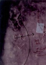
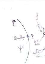
Hello Bill, I just use the standard Obsolete Spanish and Portugal Measurements for the most part, sometimes you must use X 10---X 100 and the Spanish inch is 11.56 or something in that order generally that gets me close enough I never did anything than use 1 inch = 10 paces, the old Spanish Priest, were honest in their works, Jesuit Priest on the other hand were just the opposite, It is my thoughts that The Knights Templar/Vikings/Jesuit Priest/ and probably others/ Kenworthy in his book seem to think that the Moors/Roman/Arabic/ all I think that influences the Symbols that we chase today and folk you will find lots more that are gone than you find still there, possibly as many as 50 to 1 ratio.I have found that they did use patterns tho for instance it seems that the South Canadian River starts near Santa Fe NM, in my area I can show you where the symbols are spaced every league apart East and West for 30 miles and are stacked to the North as far as 15 miles from the River every square league has a different set of symbols, The only thing that's common that I've seen are drill holes. Theres probably near to a hundred that they used and all have different meanings, all are a reference to distance and other things that's around them tells stories, one that Lost Horse posted and then that kick boxer from AZ posted four in a group they I still have dreams about Absolutely Gorgeous Posts state of the art craftsman work. Forgive my ramblings, trails are not really that complated, stay focused
 

Shortstack

Silver Member
Jan 22, 2007
4,305
416
Detector(s) used
Tesoro Bandido II and DeLeon. also a Detector Pro Headhunter Diver, and a Garrett BFO called The Hunter & a Garrett Ace 250.
Primary Interest:
All Treasure Hunting
Thanks, dsty for this follow up info.
I lived several years in the OKC area; retired from the A.F. at Tinker. (Was an ART on AWACS) I went to the state archives a few times for research, but found an interesting lead, of sorts, in a book on line. It was / is part of the Gutenberg project. Anyway, the book was written by the explorers group that went searching for the source of the Red River. It gave the Lat / Long values of the spot they buried a glass jar with their names and dates and the reason for their trip. The closest I can figure on a map; they were somewhere in northern New Mexico. I think the leader was Marcy. Your comment about the South Canadian River beginning near Santa Fe, NM reminded me of that little relic lead.

You mentioned that that one guy might have found a large cache of rich copper ore in one of the locations you found. I came across a reference to a surface vein of very rich copper ore on one of the smaller Indian reservations in the east central area of OK.
 

oddrock

Hero Member
Apr 7, 2010
560
86
Detector(s) used
Garrett , Minelab ,White's, others and B.S. sniffer
dsty,

I'm enjoying your posts very much. I agree the "Spanish" pretty well stuck to the "rules" except toward the end when they realized others were deciphering them....and they may of changed/adapted some to throw people off. (perhaps with permission) Seems most other groups were very tricky.

Oddrock
 

OP
OP
D

dsty

Bronze Member
Dec 2, 2007
1,300
736
Randal County
As best I can I will jump all the other sites and go to the one with the most information, The start was a tear drop / slice of pie rock about knee high, 40 inches long and 16 inches wide that had a map on the bottom about 6 inch X 6 inch area, go up hill 95 feet north and find a drill hole on the edge of the bluff it said to go 330 degrees 189 feet ( 1 cordel ) at that location you find another drill hole with information to go 489 feet ( 2.5 cordel ) there you find another drill hole, mark this one and continue at 330 degrees to another drill hole at 95 feet, which has all the measurements of the first three marks slice of pie = corner ( 1st ), 1st corner was the tear drop shape with the map on the bottom = corner ( #2 )drill hole on the bluff it said to go 330 degrees and 189 feet next drill hole = corner (# 3 ) 8 inch drill hole 4 inches deep with a partial block 1/2 way down. get all measurements from the corners of the triangle you will need them later when you find the two that form the triangle with the third corner that YOU must find in order to find what you seek, the measurements will be the same except they will show you 2 holes and that's a good thing mine was a hole about 6 feet across and 7 foot deep, lots more Thom, Springfield, Rangler if you guys have photos that I sent to you feel free to post them I don't know if I have anything left of them to share. They will show you the 1st triangle and give you LOTS of dig everywhere symbols-- just smile and walk on by. Takes about 7/8 minutes to say all this, that's about how many years it took me to get it figured out. Does any of this make any sense
 

OP
OP
D

dsty

Bronze Member
Dec 2, 2007
1,300
736
Randal County
The map in the previous post had the following information on it a horseshoe ( tunnel ) symbol and the date of 1814 which I found out later was referencing the 1st book of the bible, 8th chapter and 14th verse 227 cm deep, ( 7 ft 7 inches ) it also had O RO--- O = fifteenth book of the bible, ( OR = 2 ) 2nd chapter ( OR= use two times ) 15th verse = 454 = how many grams in a pound of gold, 18th chapter = 112 = number of bars in the cache, it was also verified by VL roman numeral for 45 and it was located on a boulder that was 8 feet long and 5 feet high and had the shape of a bunny rabbit, we all know that a bunny rabbit has his nest in the top of a rise where he can see in all directions, the V also showed the direction but not the distance, also down the hill there was a notch cut out of a large rock ( V ) that showed the direction but nothing for distance, so pay attention to the notches or V that that you find be they large or small it don't matter, it just might save you a bunch of steps. The guy from AZ was Clay Lindsay, Thanks Clay
 

Clay Lindsey

Full Member
Jan 8, 2010
151
6
Sierra Vista, AZ
Hey Ernie,

Welcome back! It's been a minute or two... Hey, no problem. I just hope to give back to you as much as you've given me. If you need anything else, just ask and you got it. Talk to you more soon.

Clay
 

pyledriver

Sr. Member
Dec 5, 2007
416
88
North Texas
Detector(s) used
Garrett AT Gold, CTX3030, SDC2300, GoFind 60, Whites TM-808, Dip Needle, EYES
Primary Interest:
Cache Hunting
Amazing stuff! Guess I'll be scratching that Spanish Fort stuff off my list...LOL..
 

OP
OP
D

dsty

Bronze Member
Dec 2, 2007
1,300
736
Randal County
About drill holes that I have followed and there is a probably at least a hundred different types, from the 3mm to 18 inches across, different depths, angles, different bottom configurations sharp- narrow, some have rounded bottoms, some are flat, some have information on the sides, bottom, around the top edge, some have a 3mm hole in the bottom that changes its depth, measurement, some or a lot of them are grouped together, different sizes have different meaning, they seem to to be maps of sorts regardless of the size of the hole, I pay strict attention to those that's 3mm because if its ease of being concealed, covered up by a small pebble filled with a grout material, marble size are usually maps, as with those that's of different sizes, it seems that go from large to small will get to your destination, the main thing is to keep everything drawn out on paper and pay attention to the layout, rectangle, square, triangle, some of the time the depth of the holes, just as an example 4 inch X 4 inch rounded bottom correct way that works for me is 4 Inches = 10 cm + 4 inches = 10 cm = 2 X circumference = 34.5 cm = 69 vara X 33 inches = 2277 inches divide by 12 = 190 feet or a Cordell
 

OP
OP
D

dsty

Bronze Member
Dec 2, 2007
1,300
736
Randal County
Sure does look like one, the thing is to not move it or if you do get the direction for sure, the ones on my sites point the direction to the cache not to another symbol, there will not be a symbol Lost Horse put me on to the notch theory, several on the site "Spanish Mining Markers" folks sometimes just don't pay attention, There is a wealth of information out there and it gets looked at but unless something rings a bell it don't sink in, I have referenced several of the symbols from that site, Thom,s site, Gollum,Clay Lindsay,Manning DESERTMOONS,Rangler, and all of the others that take the time to post and share giving and asking for help and then things just seem to go into thin air. The only VAULT that I have is the memories of things past, I would probably have done better if folks had posted information for me to use. The most important piece of information I can give you and its something you need to remember,--- Take all the shortcuts avaliable to you from folks on all these sites sift out all the c rap and use the information available and you may have a good shot at the 1 in 50 ( or more ) thats left. Sorry about the rant
 

OP
OP
D

dsty

Bronze Member
Dec 2, 2007
1,300
736
Randal County
Something that may help before digging a hole at your pinpoint location is if you have any kind of metal detector I found that if you set it to read ground mineral and detect your desired location, you should find a null location where the ground has been disturbed, check all around the area to make sure, it may just save a dig. If my info is right once the ground mineral has been disturbed it will never be back, hopeful the area will be about a 7 foot across circle which will give you another clue that someone or something has happened at that spot
 

Shortstack

Silver Member
Jan 22, 2007
4,305
416
Detector(s) used
Tesoro Bandido II and DeLeon. also a Detector Pro Headhunter Diver, and a Garrett BFO called The Hunter & a Garrett Ace 250.
Primary Interest:
All Treasure Hunting
dsty:
Excellent suggestion on the use of a metal detector to find the disturbed areas. If you don't mind, I'll expand a little bit on the subject.
The searcher will need a detector with manual ground balance. Turn the machine to ALL METAL and do the adjustment for manual ground balancing, BUT, instead of continuing the adjustments until the change of tone goes unchanged, leave the adjustment set so that the tone still goes UP in sound when the detector is lowered to the ground. Perform the search in ALL METAL, with the sound in your ear. When the sound "drops" down or even out, that will be an area that has been disturbed in the past.

For those folks who have an old BFO machine ( and I DO) the process is even easier. Just tune the machine to the mineral side of the null point, with a comfortable sound level. The disturbed areas will null out with this machine, also. Old time hunters would use BFO machines with large coils to hunt for caves / mines and other underground voids.
 

OP
OP
D

dsty

Bronze Member
Dec 2, 2007
1,300
736
Randal County
Thanks SS, folks don't need the deep seeking detector, just following your instructions will increases your chances, it may be just an old well that's been filled in or a root cellar, I keep forgetting to reply to your question about the cross, follow the short end or head,most everthing I find is large to small, deep to shallow, I have seen several where the rock its self had a head shape and there was a couple of 3mm drill holes also for direction and distance, my choice would be to follow the deep to shallow 3 mm, The tricky one's will also dig a hole that makes you think something was there and now its gone, leaving the actual cache site still available for discovery, They will have very good symbols for you to follow, and just a small unnoticed symbol will put you backwards to the cache site, things that may be of interest are, Snakes usually will find a den on the south side of a hill, so will a bear, a rabbit will indicate something on top, flat ground,, I have a bear profile moving between cache sites, look both ways, same thing about snakes ,The only folks that I have seen that would intermingle cache's and the symbols is KGC, Desert Moons site has so many different types of symbols, profiles, land features that it makes my head hurt. At the end of the day I feel that Drill holes holes the answers. Thanks folks
 

Shortstack

Silver Member
Jan 22, 2007
4,305
416
Detector(s) used
Tesoro Bandido II and DeLeon. also a Detector Pro Headhunter Diver, and a Garrett BFO called The Hunter & a Garrett Ace 250.
Primary Interest:
All Treasure Hunting
Thanks, dsty, for this info on the animal habits relating to the signs. If a cellar or old well is found, it MIGHT be worthwhile to dig them out, too. Relics and valuables have been found in same. :thumbsup:
 

hadji009

Hero Member
Dec 29, 2008
711
193
illinois
sized.
 

Attachments

  • Dads Pics2.jpgre.jpg
    Dads Pics2.jpgre.jpg
    14.4 KB · Views: 2,814
  • Dads Pics3.jpgre.jpg
    Dads Pics3.jpgre.jpg
    35.8 KB · Views: 2,804
  • Dads Pics.jpgre.jpg
    Dads Pics.jpgre.jpg
    28.6 KB · Views: 2,819

Old Dog

Gold Member
May 22, 2007
5,860
397
Western Colorado
Thanks Brent,
Here you go Ernie,
In the order you want them.
Sorry, making them bigger just made them grainy.
 

Attachments

  • Dads Pics.jpgre.jpg
    Dads Pics.jpgre.jpg
    28.6 KB · Views: 2,753

Top Member Reactions

Users who are viewing this thread

Top