Old log sheets for trade

signumops

Hero Member
Feb 28, 2007
756
226
U.S.
Detector(s) used
Garrett, Minelab, Aqua-Pulse
Primary Interest:
All Treasure Hunting
Ahoy ex-1715 fleet salvors;

I’ve been building software to track my mag and excavations on the old Fisher leases for about ten years. Since Bill Moore is going elsewhere, I am trying to reconstruct as much of the data on the original AutoCAD maps as possible.

In the last several months I have rebuilt my software on the latest version of the CAD component I have been using since 2001. This new package is built using some of the latest Windows Common Language Runtime vb.net code and should run on XP through Windows 7. I do not know if it will run on 64 bit versions of Windows yet, as I have built the whole thing on XP, but I have a 64 bit computer at my disposal to test on.

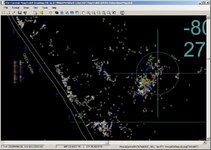
Let me get to the point. Right now, I am using this software primarily to record magnetometer surveys for the Aqua-Scan and SeaSpy magnetometers, but, I’ve gone ahead and put most of the dig charting functions into it so that I can use my old drawings in the software. I would like to get hold of all the old log sheets, especially those that were based upon sextant and bearing citations against the old beach markers. If you can furnish me with your old log sheets, or copies of them, I will plot your digs and give you a copy of the data in my program’s native file format, or in AutoCAD DWG or DXF format (or all three), AND, I will furnish you with a modified copy of the software that you can use against the original Fisher base map DWG (drawing).

However, I have not written an installer, or help files of any sort at this time, nor would I do any help file (lot of work, and I know how it works already… I wrote it). I am making this inquiry to see if anybody is interested before I go to the extra trouble.

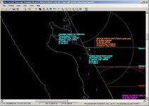
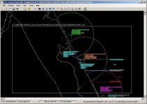
Now, the original DWG files: I rebuilt one I got from Bill in 2007, specifically for the Green Cabin wreck. If you never got one of these files on disk before, you probably got a paper plot of the area you were going to work instead. But, if you did get such a file, it was in AutoCAD format, and you would have had to have AutoCAD to make use of it. While the area of interest showed all the symbolized excavations, in layers for your specific sub-contract area, the whole lease area from north of Sebastian Inlet to Douglas Beach was included in the drawing file. In addition, I have reconstructed, using Digital Line Graph files, the area at the Power Plant wreck and the Unknown wreck which has some building footprints underlying. The file I got (and you may have had the same experience) was corrupt to some extent… I found measurement grids on the Gold layer, I found dig holes located in the Pacific, I found some attribute text located on layers without symbols for the holes, and so on. None the less, this entire project, as Bill progressed with it, was monumental, and, having done the same processing for a single salvor, I appreciate the difficulty compounded by dozens of salvors. At any rate, it took me about nine hours, but I finally got the file cleaned up to a level that I was comfortable with. There are still some misplaced fixes for dig holes, but I don’t know where they go, so I left them in place unless they were on dry land.

Certainly, if you had AutoCAD, and were saavy using it, you could probably make the digital maps work for you. AutoCAD is expensive, and, a little arcane in some respects. That’s why I started building my own plotting/mapping system. I needed certain functions and, most importantly, I needed a system that used real world coordinate systems, capable of seamlessly working in any projection, especially Geographic and State Plane. The AutoCAD file used decimal degree format, and the distance covered could only be translated that way, by reference to points calculated via decimal degree notation. I built software that can use any chart, drawing, or map which can be factored down to the U.S. Foot of measurement. I also have tools built in that permit you to set angles using various degree coordinate types. And, lastly, I have a grid tool built in that permits setting up a grid using the typical decimal minute notation we commonly record our dig holes with, where the 3rd decimal place is metered as a tic on the grid. This grid can be set dynamically anywhere in the world, based upon the feet-per-thousandth of a minute of distance. It’s all done with a click.

When the early versions of the Fisher file were built, there were holes registered that seemed to disappear in later versions. I would like to reconstruct these.

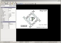
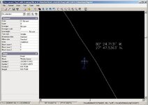
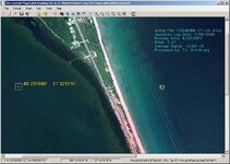
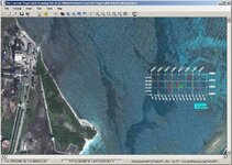
This software is called MagTrakR and here are some of its features:

Supports State Plane, UTM, Geographic or Custom projections

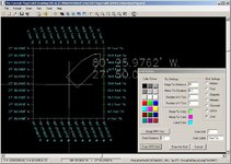
Dynamic cursor reporting in real time in foot, Degree/Minute/Second, Degree/Decimal Minute, or, Decimal Degree

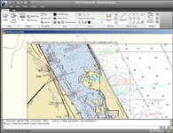
Hosts JPG2000 and ECW imagery besides TIFF, JPG, and BMP

Full World File support for imagery in TIFF and JPG

Builds World Files with a click

Robust RECENT file dialog

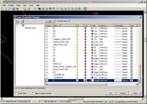
Reads and writes AutoCAD DWG and DXF, as well as proprietary LCD format

Dynamic Grid construction using any unit based upon products of U.S. Foot measurement

Dynamic Grid construction in small units suitable for workday paper plots in GPS decimal minute tics

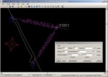
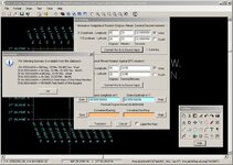
Fix dialog designed to input Degree/Minute/Second, Degree/Decimal Minute, Decimal Degree, or, Easting/Northing for map markup

Bearing dialog resets lines by forward or inverse hand-bearing compass or sextant, or combination of either

Instant bearing and distance annotation of any line entity by a single click, including Rays and Construction lines

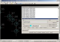
List processor dialog enables waypoint, or logfile point symbolization on the drawing and dynamic relocation for extensive data collections


If you’re interested drop me a line. I will leave all the functions in the disposable program I give you except for the magnetometer processing portion of the application.
 

Attachments

  • Image1.jpg
    Image1.jpg
    74.5 KB · Views: 153
  • Image2.jpg
    Image2.jpg
    104.1 KB · Views: 192
  • Image3.jpg
    Image3.jpg
    129.3 KB · Views: 155
  • Image4.jpg
    Image4.jpg
    82.2 KB · Views: 150

FISHEYE

Bronze Member
Feb 27, 2004
2,333
401
lake mary florida
Detector(s) used
Chasing Dory ROV,Swellpro Splash 2 pro waterproof drone,Swellpro Spry+ wa,Wesmar SHD700SS Side Scan Sonar,U/W Mac 1 Turbo Aquasound by American Electronics,Fisher 1280x,Aquasound UW md,Aqua pulse AQ1B
Primary Interest:
All Treasure Hunting
After the 2004 hurricanes i found one of the beach markers buried 5 feet down in the sand up near the dunes at wabasso beach.This one has a faded out black "A" on it with a white background that was painted over a orange background.It is now a yard ornament.
 

OP
OP
signumops

signumops

Hero Member
Feb 28, 2007
756
226
U.S.
Detector(s) used
Garrett, Minelab, Aqua-Pulse
Primary Interest:
All Treasure Hunting
After the 2004 hurricanes i found one of the beach markers buried 5 feet down in the sand up near the dunes at wabasso beach.This one has a faded out black "A" on it with a white background that was painted over a orange background.It is now a yard ornament.

Old Marker A...
 

Attachments

  • OldMarkerA.jpg
    OldMarkerA.jpg
    70.4 KB · Views: 132
  • oldmarkeraGoogleEarth.jpg
    oldmarkeraGoogleEarth.jpg
    128.2 KB · Views: 159
OP
OP
signumops

signumops

Hero Member
Feb 28, 2007
756
226
U.S.
Detector(s) used
Garrett, Minelab, Aqua-Pulse
Primary Interest:
All Treasure Hunting
MagTrakR supports any kind of underlying graphic you want to add to the drawing. Here is a section of marine chart below the Fisher base map drawing. Once the graphic is added, you can turn the layer off and on to see it or hide it. When you add the graphic and apply it World File settings, a collar along with the graphic file name is added to the drawing so that you can mortice multiple high resolution sections into the drawing on the same layer, or different layers as desired. This section of chart was snatched off marine.geogarage.com and scaled to geographic coordinates using tools contained entirely within the program.

Here's the contents of the world file:

31.2069029543
0.0000000
0.0000000
-27.3941713118822
-29324044.294617
10115913.3699869
 

Attachments

  • SansChart.jpg
    SansChart.jpg
    83.5 KB · Views: 137
  • WithChart.jpg
    WithChart.jpg
    183.2 KB · Views: 141
  • ChartCollar.jpg
    ChartCollar.jpg
    85.1 KB · Views: 154
OP
OP
signumops

signumops

Hero Member
Feb 28, 2007
756
226
U.S.
Detector(s) used
Garrett, Minelab, Aqua-Pulse
Primary Interest:
All Treasure Hunting
The DWG produced by MagTrakR is compliant with AutoDesk Standards. Here the drawing saved in DWG format, including the underlying chart is being displayed in AutoDesk TrueView 2010. Note the decimal degree coordinate value has now been produced in raw feet from the prime meridian and the equator. However, measurements in raw feet from within the drawing are now usable as foot measurements without external calculations.
 

Attachments

  • MarineChartDWGTrueView.jpg
    MarineChartDWGTrueView.jpg
    181.8 KB · Views: 191

Southern_Digger

Hero Member
May 21, 2012
573
221
Florida
Detector(s) used
Minelab Explorer and Excalibur; Tesoro Tejon; Fisher 1265-X; Garrett Master Hunter; White's Coinmaster; In closet: Bounty Hunter and Relco
Primary Interest:
Other
You are definitely doing it right. And, it appears what you are mapping is more of a GIS program used with autocad. Having made my living in Engineering using autocad since 1982 and until recently, I volunteered to assist and map a mid 1800's merchant shipwreck in the Bahamas. At first, I thought I may get the project. However, a University came forward and landed that task, thus using it to educate their students. I couldn't argue against that of course because I was in agreement-use the wreck to educate. I actually first used autocad in 1983 to map the footprints of an 1840's coastal settlement site. I made it public in a historical exhibit -open to the public, of course. It was judged and won top award. The subject matter was focused on the use of computers in archeology. It was an apparent assett, having received a plaque from the mayor. However, it did not earn me one thin dime-it was all voluntary. I used autocad in the mapping of another land project in 1988-89, volunteering to map a Florida fort site before it was dozed and developed. The community or county showed no interest at saving the site-I suggested a park be established there--however, the land was too prime and valuable. The developers cooperated with me and their surveyor laid out baselines thru the site. I mapped everything according to this using autocad. I have yet to publish this information as of yet because certain agencies after the fact became sour and condemned my work, despite the accuracy; and thus blackballed me from earning a living in such endeavors-despite that all my work was conducted on private property with permission and only was made available to me because no such government agency saw any benefit to save this information or the artifacts in the first place. Its a dirty world we live in... On one project in the early 1980's I had a u/w salvage team volunteer to assist me in there off-season, to map and dig yet another private property site, with the approval of the local historical society; who, as they did me, stopped them from seeking the Jupiter Wreck and sent them my way to assist on the land project. I placed them in the Volunteer camp at Jupiter, which I discovered in 1980. Of course, that was covered up later too and someone else-one of my later volunteers who I trusted with site information to assist and share data for the overall sites project which I had began in 1978 with the full approval and encouragement of the local society... Well, the volunteer I had trusted received statewide credit for discovering that camp some seven years later and was promoted into archeology. I knew that competition to locate and search u/w sites was near cut-throat, however, now I witnessed that pouring over into land sites as well and for those seeking government-approved positions. Hence, there are at least two big time treasure hunters who thought nothing to rape a site for relics, now accepted in archeology, representing the state. It wasn't always that way, the archeologist who mentored me was well respected by all, being in the field since the 1940's. I'm getting away from the subject--I recommend you use the old school autocad method. Once, you receive this old, historical site mapping information, create each as a slide file in an earlier version of autocad, and provide it that way back to those who cooperate this information. That way it cannot be changed, yet, is pertinent information to benefit those who work the site area. Yes! I am old school...
 

OP
OP
signumops

signumops

Hero Member
Feb 28, 2007
756
226
U.S.
Detector(s) used
Garrett, Minelab, Aqua-Pulse
Primary Interest:
All Treasure Hunting
Actually, AutoCAD is not old school by any stretch, however, it is a product for engineers. I am not an engineer. There was a point in time when there was a tremendous product offered by AutoDesk called AutoSketch, and I used it extensively for a number of years, wrote articles about it for Cadence Magazine, and actually taught a few seminar courses at AutoDesk University in Frisco in the 80’s in the use of AutoSketch. It has since become a pixel based product without the strength of vector drawing. I still use the latest edition on occasion because it supports my Wacom digitizing pad.

There was an incident in Palm Bay Florida around 1985 where this lunatic by the name of William Cruse shot the town up one Friday evening, killed a couple of cops and seven other people. I was in plain clothes at the time and spent the better part of an hour pinned down by the ******* while bullets whizzed by. Long story short: we captured him and one of the biggest trials in Florida history got underway. Since I was the computer guy at the time, the chief put me onto assisting the SAO for the case. As a result, I did a lot of large scale crime scene mapping with AutoSketch (EGA video, Windows 3… I had no mouse at the time). I also built a database with all the witnesses using freeware dBase interfaces which I eventually linked into the first Windows based version of MapInfo, wherein I was introduced to GIS, as it were.

A few years later I found myself working for the Monroe County Sheriff’s Office in Key West, where I ushered in the first PC’s into service, the first CDPD mobile Law Enforcement terminal network, and a lot of GIS crime mapping stuff. But, probably most important was a contract I took to write a building mapping/appraisal system for a government office, which needed a pen-based computer app for drawing buildings with accurate dimensioning. I built it with Visual Basic and the first true CAD component available on the market called TrueCAD.VBX. TrueCAD was a superior CAD engine and it was written by a fellow in South Africa. It faded away when Windows went to 32 bit architecture. But I had learned a great deal of math, how to handle parameters, layering, dimensioning routines and so forth. Subsequently, I took a contract to draw a vector map of the entire Florida Keys to support a project being done on behalf of the Florida Keys Environmental Restoration Trust Fund. Foot soldiers took paper charts into the field, located exotic invasive plant species and then brought their boundary files back to me for inclusion in the map. There was a requirement to know the locations of the affected areas and their square footage… easily done with CAD and a few dimensioned polygons. I did all of it with my TrueCAD based program, but it was probably a job more suitable for a GIS. I have always appreciated vector data and do not like dealing with the unpredictable behavior of metafiles, which are the soul of GIS.

In 2000 I returned to the Treasure Coast area and finished a 10-year stretch as a GIS programmer and photogrammetry hack in 2010. All ten years I worked during the summer on the 1715 fleet contracts as a diver. Over that period I wrote lots of scanning software, cad software, a system to recreate boundary plots based strictly upon legal descriptions and so forth. I used a component written by Oleg Kolbaskin in Russia to put much of this together, and MagTrakR is a vb.net framework for his 2D CAD engine, LiteCAD. I have no other interest in writing cadware aside from salvage and treasure hunting at this time. I don’t build anything I don’t use.
Treasure hunters seem to run helter skelter much of the time, and many are less than systematic in their daily target choices. Hunch-shooting holes is a waste of time. Use of computerized metrics along with GPS means this is not necessary, nor, statistically profitable. It costs too much to treasure hunt without being certain of where you have already looked.

I was astonished to find that it was not particularly difficult to build magnetometry mapping software and I have been at it for more than 5 years. I have had a lot of SeaSpy data to work with, and some AquaScan data as well, which is what I wrote for in the first place. But I do disagree with you on one point: it does not matter how you save your data, somebody can make of it whatever they like, whenever they like. All you can do is maintain a copy based upon true results, which are repeatable. That’s the nice thing about CAD… it’s precise and based upon mathematical fact. Math can make a liar out of anybody, instantly.

MagTrakR is used to help you make a decision about where to setup and dig. I built it just for that and will continue to develop it and refine the mag signal processing. BTW, I have a PDF that explains how mag files are processed by MagTrakR for those that might be interested, but it is about 8 megs in size, so feeble email systems won’t pass it through.
 

Attachments

  • Image5.jpg
    Image5.jpg
    117.5 KB · Views: 124
  • Image6.jpg
    Image6.jpg
    126.9 KB · Views: 138
  • Image8.jpg
    Image8.jpg
    111.9 KB · Views: 120
  • Image10.jpg
    Image10.jpg
    111.7 KB · Views: 138
  • Image14.jpg
    Image14.jpg
    210.7 KB · Views: 138

Southern_Digger

Hero Member
May 21, 2012
573
221
Florida
Detector(s) used
Minelab Explorer and Excalibur; Tesoro Tejon; Fisher 1265-X; Garrett Master Hunter; White's Coinmaster; In closet: Bounty Hunter and Relco
Primary Interest:
Other
As I said before, the way you are mapping the entire area is the right way--thus guaranteeing better results/productivity. Also, it shows the state that serious professionals are undertaking the task of recovering not just treasure, but historical artifacts too. However,you misunderstood me. I never said Autocad was old school. I just recommended using old school methods. To better explain what I meant... As you probably know, in the early days of autocad, the computer memory could not handle the file size of large mapping projects. Furthermore, file interchange was a problem because not every company who had autocad, did not have the same version. Hence, in pre DXF days, we relied on slide (.sld) files to transfer scaled graphics (no file info contained within)-owing to the small memory usage. We would take huge drawings, impossible to save due to limited memory. We would rebuild the graphics with several slides, then print it-saving it only as reduced multi-file source. Examples of files I had to build in this manner from several matched slides was the one of the early digitized state maps used by FDNR. I had digitized that on a large table. Then I dig'd several maps for SFWMD in the same manner. These maps included the keys. Because we were able to do this for the state and the district, it landed us much more work. Other project causing memory issues, also accomplished by the use of slide files was my digitizing several topography maps for south Florida; and, plat maps for the City of Ft. Lauderdale. Anyhow, if you use such a file on older collected data submitted to you by others who cooperate with this project, it can be used as a layered graphic, yet, setup as a sld file, thus using less memory and easily transferable among the many versions of Autocad that are being used by a host of clients. I know all about the power of the software, especialy after computer memory issues were resolved. I liked the older versions because I preferred to write my own lisp routines; and sometimes I enjoyed trying those published in Cadence and Cadalyst. However, digitizing, then resizing the x-y factors to maintain guarantee scale was my specialty. Before the Mechanical piping companies ever had cad software of their products; I digitized, or drew their supply manuals of pipe, fittings, pumps, motors, ect. Then, after consulting with my first Cad teacher (1982), I used his menu writing methods to create specialty menus for such hardware; pumps, motors; also all Florida Dept of Transportation supply manual of piping Inlets, manholes and such--all before this years before it became available as a standard cad symbol library. I wrote quick reference drop down menus; pop down menus using lisp and block insertion techniques; Mapping symbols; Hydrogeology symbols used when early GIS was first introduced with acad. Some of these product dwg. blocks were actually given by me to vendors so they could create a product cad library, available to their other clients. Anyhow, the menu I created was much quicker than the tablet system but politically, it was not utilized and I was condemned for using it other than the tablet system. As I did not want to live and work for a company wearing blinders, I did not comply and it cost me a job I had nearly 15 years. After I left, I learned they took my menu and began redeveloping it to use in place of the tablet system-without my permission. Notably, most of it was created at home on a word processor, yet that did not stop them from stealing it and not providing me credit. So, I took the menu to two other companies after that, wrote it to their preferred standards and gave it away as it was acad driven, and as expected, someone else tried to steal it and take credit as the creator. Hence, I chose to make it public to the company I worked for and it was adapted and used as a national company standard. All designs were based upon AIA/ASCE guidelines. When I set up a CAD dept, hired, trained and managed a team of employees or temp contractors to work together on cad designs such as water and wastewater plants; street utilities and so forth, each used the menu and it guaranteed the final product would look like it was done by one person rather than 4 or 5 designers. I last created one for Civil Engineering applications and took a dead mom and pop engineering firm from $50 k in the hole to a company that did an average of $500,000 .00 per year. The menu implemented all necessary blocks, and before the recession the projects were endless, it was not uncommon to create a seven page drawing set to 85% completion in 9 to 15 hours. My downfall was the architects who provided the preliminary design files were just that, preliminary and often out of scale. So, I reset the property using surveyor units, fixed many problems that could lead to lawsuits from out of scale drawings and built the files from that corrected level of accuracy. Somewhere along the line, the owner-engineer did not want me to change the prelim. architect designs whatsoever. As I was the project manager, I would not comply and was let go because they thought it would increase productivity if I used the prelim. architect files and just draw over them. That is not engineering nor accurate design so I did not comply. The person who did got my job and I am not surprised if this cartooning practice did place them into a costly design error or worse yet, a lawsuit. My last version of autocad was 2006. However, I prefered to use acad2000 for implementing the menus. If you wrote for the cad magazines in the past, it is most likely we had corresponded by email in the past. Somewhere along the line, the perception from some companies is how fast can you create it, not how accurately. After the recession started, I had not worked in cad for the past 5 years. Do I miss it? Maybe I do and sometimes I don't-depends on if they want acurate results or cartooned files.
 

Top Member Reactions

Users who are viewing this thread

Top