Pennsylvanias Cannon Hole ? old time race ground island? Lycoming county

jeff of pa

Super Moderator
Staff member
Dec 19, 2003
85,872
59,652
🥇 Banner finds
1
🏆 Honorable Mentions:
1
Primary Interest:
All Treasure Hunting
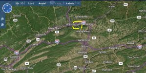
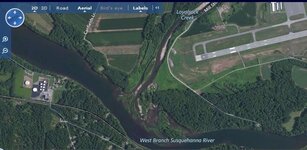
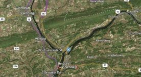
the Tradition of the Cannon Hole at the Race Ground Island, in the West Branch,of the Susquehanna river as told the English by the Indians after peace, was that a party of French and Indians had left the lake country in the fall of 1756 to make permanent advance to the forks of the Susquehanna, bringing along three small brass cannon. Striking the headwaters of the Susquehanna (West branch), they descended by water to about the mouth of Loyal Sock creek, where, landing, they sent a reconnoitering party to the top of the Blue hill overlooking the forks and Fort Augusta, then partially built. Seeing the advancement of the fort and the number of men guarding it, considered it imprudent to attack and so reported to the main body who after consultation, decided to return; as the water was falling, finding themselves encumbered with their cannon, they threw them in the deep pot hole, or eddy, at the upper end of the old time race ground island, which has been known as the Cannon Hole ever since. Fort Augusta continued on the alert for French aggressions until some time after the capture of Quebec by Wolf in 1759, which virtually decided the control of the Canadas and, of course, of the Indian allies of the French.

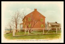
Fort Augusta at Sunbury, Pennsylvania
Untitled.jpg
 

OP
OP
jeff of pa

jeff of pa

Super Moderator
Staff member
Dec 19, 2003
85,872
59,652
🥇 Banner finds
1
🏆 Honorable Mentions:
1
Primary Interest:
All Treasure Hunting
It had been an easy matter for them to float their brass cannon down the stream on flat boats or rafts, but it was a physical impossibility to float them back again. The only way they could have succeeded in getting them up stream again would have been to pole them up, a long and laborious task. Tradition has it, therefore, that they sunk the cannon in the river near the mouth of Loyalsock Creek at a place which has since become famous fishing ground and has always been known as the "Cannon Hole." Frequent attempts have been made to raise these cannon to the surface at this place, but if it is true that they were actually sunk there, the chances are that they have become so deeply buried in the mud at the bottom that they will never be resurrected. No other plausible origin of the name, "Cannon Hole," has ever been found.

History of Lycoming County, Chapter 2
 

OP
OP
jeff of pa

jeff of pa

Super Moderator
Staff member
Dec 19, 2003
85,872
59,652
🥇 Banner finds
1
🏆 Honorable Mentions:
1
Primary Interest:
All Treasure Hunting
That there was a camp at the spot mentioned, nearly opposite the mouth of Loyalsock, there is positive evidence, for the early settlers found French buttons and other trinkets at that place. Near the summit of the mountain, on the Indian path, the remains of camp kettles, spoons, and other utensils were found, showing that a body of French had been there. Probably St. Ours and his party lay here, while the Indians remained in the camp on the bank of the river.


When the scouting party returned from Shamokin and reported that the force was insufficient to reduce the fortification, preparations were made to return to their strongholds on the Allegheny. Here M. de St. Ours was confronted with a serious difficulty. He had floated down the river very easily with his cannon, but he could not return with his flotilla up stream; and the Indian paths were too narrow to drag his guns back again. What was to be done with them? He did not want them to fall into the hands of the English, as they certainly would, if left in the abandoned camp. After consultation with his comrades it was decided to cast the guns into the river. Deep water, where it was not likely they would be discovered, was found a short distance below the camp, and into it they were thrown and quickly went to the bottom. This place for more than a hundred years has been known as the "Cannon Hole." How the fact of the guns being placed there leaked out is unknown, unless some of the Indians who accompanied the expedition afterwards informed the whites. For many years the "deep hole "has been filled with gravel and the French guns are no doubt buried beyond all hope of resurrection.
The war was continued without cessation for several years, and many white settlers were killed. The West Branch country, particularly that portion included in the limits of Lycoming county, was constantly infested with roving bands of savages bent on pillage and murder. Their headquarters were on and about the Great Island and it became necessary to send expeditions there to dislodge them and destroy their towns.

History of Lycoming Co. PA edited by John F. Meginness; ©1892


RushinPA

Jr. Member
Mar 11, 2010
72
22
Gardners, PA
Detector(s) used
Tejon, F-75
Hey Jeff, in text of one of your links refers to the Battle of Fort Freeland in Northumberland county. Have you heard of this event?

Job Chilloway was a Delaware Indian, born in New Jersey early in 1737 and on reaching manhood he came to the West Branch of the Susquehanna River where he became a firm friend of the white man and rendered very distinguished service. He died in Ohio on September 22, 1792.
Another manor was surveyed on the east side of Lycoming Creek on land on which a part of the city of Williamsport now stands, and a patent was issued for it to Rev. Richard Peters August 11, 1770. It contains 579 acres and was known as "Orme's Kirk." It played an important part in the subsequent history and development of the city of Williamsport.
At one time this tract was in the possession of Captain Hawkins Boone, brother of the celebrated Daniel Boone of Kentucky. Hawkins Boone fell at the battle of Fort Freeland in Northumberland County, July 29, 1779.


Just mentioning for any locals. Much of the text of the two links refers to "The Great Island" as a meeting place for indians and traders. One is listed near Loch Haven, I would suppose this it the mentioned island. Sounds like a nice daytrip, or weekend excursion.

Thanks for the information
Chuck
 

OP
OP
jeff of pa

jeff of pa

Super Moderator
Staff member
Dec 19, 2003
85,872
59,652
🥇 Banner finds
1
🏆 Honorable Mentions:
1
Primary Interest:
All Treasure Hunting
Hey Jeff, in text of one of your links refers to the Battle of Fort Freeland in Northumberland county. Have you heard of this event?

Job Chilloway was a Delaware Indian, born in New Jersey early in 1737 and on reaching manhood he came to the West Branch of the Susquehanna River where he became a firm friend of the white man and rendered very distinguished service. He died in Ohio on September 22, 1792.
Another manor was surveyed on the east side of Lycoming Creek on land on which a part of the city of Williamsport now stands, and a patent was issued for it to Rev. Richard Peters August 11, 1770. It contains 579 acres and was known as "Orme's Kirk." It played an important part in the subsequent history and development of the city of Williamsport.
At one time this tract was in the possession of Captain Hawkins Boone, brother of the celebrated Daniel Boone of Kentucky. Hawkins Boone fell at the battle of Fort Freeland in Northumberland County, July 29, 1779.


Just mentioning for any locals. Much of the text of the two links refers to "The Great Island" as a meeting place for indians and traders. One is listed near Loch Haven, I would suppose this it the mentioned island. Sounds like a nice daytrip, or weekend excursion.

Thanks for the information
Chuck

I haven't researched it closely Chuck, but read the story of of it in

Report of the Commission to locate the site of the frontier forts of Pennsylvania vol. 1

frontierforts.html

freeland.jpg
 

Last edited:

JrMack

Full Member
Feb 16, 2014
227
179
steuben co. ny
Detector(s) used
bounty hunter, x-terra 305/505/705,discovery TF 900
Primary Interest:
All Treasure Hunting
I have read that there was an indian encampment at Galeton on Pine creek in tioga county and have read of prisoners taken and brought there. Also there was a great Island at Osceola Pa on the Cowanesque river where the Indians grew crops on the flats during summers.
 

kromar3336

Jr. Member
Mar 15, 2015
72
66
Pgh Pa
Detector(s) used
Garrett Ace 250
Primary Interest:
All Treasure Hunting
Great story ! Thanks for posting. Lots of history in Pa. Love to read about it.
 

MagikMan

Newbie
Sep 7, 2015
1
2
Dornsife, PA
Primary Interest:
Other
Bits to consider...

That there was a camp at the spot mentioned, nearly opposite the mouth of Loyalsock, there is positive evidence, for the early settlers found French buttons and other trinkets at that place. Near the summit of the mountain, on the Indian path, the remains of camp kettles, spoons, and other utensils were found, showing that a body of French had been there. Probably St. Ours and his party lay here, while the Indians remained in the camp on the bank of the river.


When the scouting party returned from Shamokin and reported that the force was insufficient to reduce the fortification, preparations were made to return to their strongholds on the Allegheny. Here M. de St. Ours was confronted with a serious difficulty. He had floated down the river very easily with his cannon, but he could not return with his flotilla up stream; and the Indian paths were too narrow to drag his guns back again. What was to be done with them? He did not want them to fall into the hands of the English, as they certainly would, if left in the abandoned camp. After consultation with his comrades it was decided to cast the guns into the river. Deep water, where it was not likely they would be discovered, was found a short distance below the camp, and into it they were thrown and quickly went to the bottom. This place for more than a hundred years has been known as the "Cannon Hole." How the fact of the guns being placed there leaked out is unknown, unless some of the Indians who accompanied the expedition afterwards informed the whites. For many years the "deep hole "has been filled with gravel and the French guns are no doubt buried beyond all hope of resurrection.
The war was continued without cessation for several years, and many white settlers were killed. The West Branch country, particularly that portion included in the limits of Lycoming county, was constantly infested with roving bands of savages bent on pillage and murder. Their headquarters were on and about the Great Island and it became necessary to send expeditions there to dislodge them and destroy their towns.

History of Lycoming Co. PA edited by John F. Meginness; ©1892


Hi Jeff,
Great work and I have some to add. I did some research in the 80's about this and have my twist to the story. The cannons actually made it down the west branch to just south of Winfield. There they were taken by the French and Indians on shore headed to Blue Hill to fire on Fort Augusta. It was rainy and cold but they hacked the 'Wilderness Path' with travel laboriously slow. An advanced French spotter worked his way to the top of Blue Hill and realized the operation was in serious trouble. Fort August was way more defended than they were lead to believe. The spotter scouting party returned to the main contingent with the cannons and explained what they saw. The party wasn't no more that 1 mile from the west branch. The decision was made to do an about face and hack the 'Wilderness Path' north to the south side of the west branch. When they made the 23 miles trek, they were exhausted. Dump the cannons in the river was ordered and the heavy wood carriages were left in the woods to the south 'some distance'. This was all gleamed at the Northumberland Historical Society in Sunbury (Shamokin of the day). The best supporting work is the 'Hermit of Blue Hill' forgot the authors name. In the 80's there were no computers, the internet, or even cell phones with GPS. I found what looked like the 'Wilderness Path' and followed it for about 5 miles. It was headed in the right direction but with so much farming going on, it was more like a 'maybe' rather than a 'that's it' sort of thing. Just my two bits.
 

Oroblanco

Gold Member
Jan 21, 2005
7,838
9,830
DAKOTA TERRITORY
Detector(s) used
Tesoro Lobo Supertraq, (95%) Garrett Scorpion (5%)
Great article Jeff, thanks for posting it. In researching for an article on the missing cannons of the Susquehannocks, I ran across several mentions of witnesses that claimed the French cannons were visible on the river bottom at Cannon Hole for over 100 years after the French and Indian war, but floods in the late 1800s brought more mud/silt into that spot and they were no longer visible.

Please do continue, PA history is a very interesting story! :thumbsup:

:coffee2: :coffee: :coffee2:
 

Top Member Reactions

Users who are viewing this thread

Top