River survey, hints needed

Alexandre

Bronze Member
Oct 21, 2009
1,047
435
Lisbon
To all remote sensing and river experts out there

We will be surveying some 30 miles of a small river, where navigation was frequent - the Phoenician, the Romanm the Visigoths, the Muslims, the Crusaders, the medieval Military Order of Santiago, all up to Napoleonic era river ships, all have sailed there.

if we scrap Pre History occupation, we are looking at around 4000 years of riverine navigation (this being the only way out for iron, copper and silver ore, cereals and salt, as well as being the only way in, and across, for armies, peregrines and passangers) and, hopefully, some wrecks and cultural deposits.

This river has never been dredged and has had only a medium size dam built further upstream.


Being integrated into a natural park, it has no houses or other infrastructures (besides the occasional road or bridge) built on, or around, it. It stays as it ever was, although with significantly less water being carried.

It's breadth is between 200 and 150 meters, sometimes less.


The depth, we are not sure, but we think it varies anywhere between 0 and -10 meters.

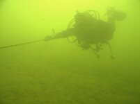
It has never been dived. Visibility upstream is mainly nil, but this varies, as the hight tide can reach up to 30 km inland.

Sediments consist of mud, silt and, downstream, some patches of sand.

The scarce finds reported are Roman amphorae, a Roman coin hoard - and thats about it.


We have no historical documents that narrate losses or shipwrecks, only medieval documents that point to an intense river trade and activity.


We intend to speak to fishermen and the rare wooden boat owners that know their way around for possible sites.

I am figuring a mag survey will be most useless, as the possible sites we are contemplating will be having very few iron artifacts within them.

I am also figuring a side scan sonar will be pointless as all sites will be buried in silt... so, how would you do it?

Any hints greatly appreciated.


SADS 669

Bronze Member
Jan 20, 2013
2,454
3,737
Long Island, Bahamas
Detector(s) used
Tesoro Sand Shark....Aqua pulse 1B....Equinox ll
Primary Interest:
Shipwrecks
Sadly, ( because it's a pain), I think you are at the point of connecting divers ( very experienced ones) side by side and then mow the grass into the current if it's not too strong with fingers ( gloved) to see what's just under the surface. With it being 30 miles this probably only works at hot spots.

Then, I think you are going to have to put some silt up into the water column to flow away from sites where you may find a thing or two. Knowing your archeological background I believe you are almost certainly going to have to do this the very old fashioned long and slow way......

Send me a pm if you wanna chat more about dive ideas.....an underwater gps ( the buoy on the surface type) might be a great idea at these shallow depths.

ImageUploadedByTreasureNet.com1486989783.060560.jpg
 

Last edited:

ropesfish

Bronze Member
Jun 3, 2007
1,190
1,998
Sebastian, Florida
Detector(s) used
A sharp eye, an AquaPulse and a finely tuned shrimp fork.
Primary Interest:
Shipwrecks
If it were me-
I would start by looking at satellite imagery to determine if there have been changes in the river's path. Flooding can change the course of a river over time. Make sure that you are looking where the river was, not just where it is now.
Rivers have obstructions, some that are mobile like downed trees, that we do not see in our usual deep blue sea environment. Map it with a hull-mounted CHIRP sidescan sonar (I would not risk a towed unit in an unknown riverine environment) so you will know where the obstructions are, so as not to lose your very expensive rented/leased/purchased gear on the next steps - then as Aquanut says, cesium magnetometer (identifies the more recent deposits of iron whether it is a ship's boiler or a 1951 Volvo) then a 3-D CHIRP sub-bottom profiler.
The CHIRP equipment does give a higher resolution result than the earlier technologies, IMHO.
There are post-processing programs like Hypack and SonarWiz that can stitch all the information together and allow you to display it in layers. SonarWiz can import and mesh almost any equipment's results into a single layered map.
If it is heavily traveled or fished, one might be able to market the results of the sidescan survey as a map and defray some expenses.
Voila'.
Then call Kevin James to train/organize your dive team.

Edgetech, Kongsberg, Teledyne all make the quality of sub-bottom equipment that this will require.
 

Jolly Mon

Hero Member
Sep 3, 2012
868
631
Primary Interest:
All Treasure Hunting
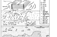
Sans the obvious use of a sub-bottom profiler, my suggestion would be to attempt to use topographic maps, historical records and just plain common sense in an attempt to locate riverside sites of old wharves, piers and quays. Not only will you stand a great chance of finding wrecks, but at heavily used historical sites, you will undoubtedly find many cultural artifacts that were simply dropped into the water inadvertently. Look for relatively deep water close to shore and near a historically important thoroughfare.

Believe it or not, metal detecting in zero visibility and swift current is entirely possible...a non motion detector like the Aquapulse or even an old Garrett Sea-Hunter is the ticket. Use the side of the coil to pinpoint.

Incidentally, sometimes old wharf/pier pilings can last an incredibly long time in an intertidal environment. You probably won't be able to locate the pilings of a wharf built or frequented by Phoenicians, but often times good landing sites remain in use for many years for obvious reasons.

mepkin abbey scatter pattern.png
 

Last edited:

hobbit

Sr. Member
Oct 1, 2010
304
110
It is curious that a university trained marine archaeologist would come to a treasure hunting website for suggestions on conducting an initial archaeological survey. Kudos for having the cojones to come to this forum for advice.
 

modrian

Jr. Member
Dec 8, 2003
36
5
Alexandre has been a longtime contributing member here- I know people have issues from the past, but lets help him out. He is obviously looking into a diving condition that he may not have the equipment available to him and his resources, as many of you have done so or ideas on how it may be done. We are a community- while only an armchair viewer, any input we hear helps, and keeps the community going. The tech being discussed could be help for other in their searches. Not everyone searches in the same waters, temperature, visibility, or even targets. The sharing of our knowledge helps everyone, regardless of your targets and pursuits. I don't think what he is going after is anything most commentators here should be worried about. I enjoy your input, and I wish you luck Alexandre.

Cheers;

-Modrian
 

Darren in NC

Silver Member
Apr 1, 2004
2,780
1,574
Detector(s) used
Tesoro Sand Shark, Homebuilt pulse loop
Primary Interest:
Shipwrecks
Ropefish nailed it in his post. I couldn't have said it any better. You'll have the best chances if you follow his advice. I like that you're using the time tested method of speaking with fisherman and local navigators, too.
 

agflit

Hero Member
Mar 25, 2015
624
1,086
Wisconsin, N.C. Fl, Bahamas....wherever the wrecks
Detector(s) used
Tesoro Tigershark freshwater...Excaliber 1000 Bluetube, Aquapulse AQ1b, Marine Sonics Centurian SSS
Primary Interest:
Shipwrecks
I'd second both Bill and Kevins advice....treasure hunting starts with research...research..than more research.

Whats your target? whats the riverbeds geologic path? what specifically are you looking for? is it heavy or light? does that river have a flood history? whats the bottom composition and to what depth? will fast water move finds into holes? will slow water bury everything with little movement??...

just a few things I would be asking myself...

I live in low to no viz river and lake conditions...and metal detect blind ALOT. Lay a jack stay search pattern and plan on spending the next 50 years covering lol

Seriously reread Kevin and Bills advice...than make DAMNED good and sure you have QUALIFIED low/no viz divers capable of doing the job..these kind of search conditions are NOT for the faint of heart...

Just my opinion...good luck.

ag
 

Red_desert

Gold Member
Feb 21, 2008
6,860
3,507
Midwest USA
Detector(s) used
Garrett Ace 250/GTA 1,000; Fisher Gold Bug-2; Gemini-3; Unique Design L-Rods
Primary Interest:
All Treasure Hunting
Some wrecks have documented historical accounts of how and where the wrecks happened. Others were in more ancient times, you cannot find out where by researching materials. That is why SADS and others recommend go look all the obvious places. Or as the saying goes "Seek and Y'awlt to find" mispelled in sailor style.
 

Top Member Reactions

Users who are viewing this thread

Latest Discussions

Top