Similarities of the Perfil Map and Frog Tanks Trail

markmar

Silver Member
Oct 17, 2012
4,117
6,259
Primary Interest:
All Treasure Hunting
Well Marius, I guess the Ldm by now looks like a shallow depression up on a side of a rocky hill. There should be something left behind by somebody. And then there's your third eye!

I believe is very hard to find a ground depression in a very rocky mountainside .
IMO, the LDM is in a trench about 2 feet large , on a ledge about 12 feet long and about 5 feet high . The characteristic of that ledge is how has a triangle shape pointing south , with the western side to be shorter than the eastern .. The LDM is about half way on the eastern side of the triangle ledge .
 

Last edited:
OP
OP
393stroker

393stroker

Hero Member
Jun 27, 2012
505
789
HOUSTON
Detector(s) used
Garrett pro-something
Primary Interest:
All Treasure Hunting
A two foot trench on a twelve foot ledge, about five foot high, shaped like a triangle. OK, I'll keep an eye out .😉
 

Last edited:

markmar

Silver Member
Oct 17, 2012
4,117
6,259
Primary Interest:
All Treasure Hunting
A two foot trench on a twelve foot ledge, about five foot high, shaped like a triangle. OK, I'll keep an eye out .

This is not enough . You have to know what is at the east of the ledge and to the south .
 

OP
OP
393stroker

393stroker

Hero Member
Jun 27, 2012
505
789
HOUSTON
Detector(s) used
Garrett pro-something
Primary Interest:
All Treasure Hunting
Just guessing here, the water tanks are north, the cave is across the ravine to the west, a cross is to the east, and a frying pan is south. I actually found a folding frying pan down the ravine from the pit mine, before the propane tank.
 

Old

Hero Member
Feb 25, 2015
656
1,409
Virginia
Detector(s) used
Whites
Primary Interest:
All Treasure Hunting
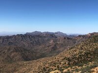
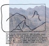
........and if you climb a little you just might see this..........

needle6.jpg

or this.......
gunsight map.jpg

or maybe this.........not too far off if you consider it was drawn from memory about a decade later....hmmmmmmmmmmmm
gunsight map overlay.jpg
 

markmar

Silver Member
Oct 17, 2012
4,117
6,259
Primary Interest:
All Treasure Hunting
Just guessing here, the water tanks are north, the cave is across the ravine to the west, a cross is to the east, and a frying pan is south. I actually found a folding frying pan down the ravine from the pit mine, before the propane tank.

Chuck

I meant , what is next off the trench .
 

EarnieP

Hero Member
Jul 20, 2015
526
1,062
Primary Interest:
All Treasure Hunting
Chuck

I meant , what is next off the trench .

An OSHA required 2 foot clear space between trench and excavated soil, sloped or benched sides, a ladder not more than 25 feet from any spot along the trench, a warning system along the length of the trench (barricades, hand or mechanical signals), a protective trench box (in trench) when required, and last but not least, a 'competent' person.:laughing7:
 

wrmickel1

Bronze Member
Nov 7, 2011
1,854
1,392
Jamestown ND
Detector(s) used
Garrett 2500
Primary Interest:
Other

markmar

Silver Member
Oct 17, 2012
4,117
6,259
Primary Interest:
All Treasure Hunting
Ok , more clear . What landmarks are next off the ledge and close to the trench .
 

OP
OP
393stroker

393stroker

Hero Member
Jun 27, 2012
505
789
HOUSTON
Detector(s) used
Garrett pro-something
Primary Interest:
All Treasure Hunting
Well if we're talking about the area I suspect where The mine is, there is a large square rock formation with an elongated corner running down the front side. I remember thinking of how square and plumb it looked.
 

markmar

Silver Member
Oct 17, 2012
4,117
6,259
Primary Interest:
All Treasure Hunting
Well if we're talking about the area I suspect where The mine is, there is a large square rock formation with an elongated corner running down the front side. I remember thinking of how square and plumb it looked.

Yes , there is a large rock but is not square . Maybe was misinterpreted because all the place there is full of squares and triangles , made by ledges . The ledges are not at the same altitude and the place looks like has terraces .
That large rock is depicted in a map , exactly how it is.
 

Last edited:
OP
OP
393stroker

393stroker

Hero Member
Jun 27, 2012
505
789
HOUSTON
Detector(s) used
Garrett pro-something
Primary Interest:
All Treasure Hunting
I think we're talking about two different areas, I've been to mine.
 

OP
OP
393stroker

393stroker

Hero Member
Jun 27, 2012
505
789
HOUSTON
Detector(s) used
Garrett pro-something
Primary Interest:
All Treasure Hunting
Chucks area

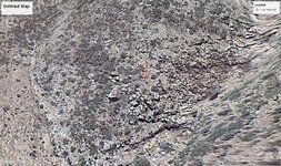
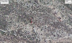
Here`s some GE shots of the area I`m talking about. It`s a few miles north of the Pit mine, and kind of hard to get to. WORTH A LOOK.jpg LOOK HERE.jpg
 

Ditlihi

Banned
Aug 20, 2016
1,227
4,793
Primary Interest:
All Treasure Hunting
Yes , there is a large rock but is not square . Maybe was misinterpreted because all the place there is full of squares and triangles , made by ledges . The ledges are not at the same altitude and the place looks like has terraces .
That large rock is depicted in a map , exactly how it is.


A chevron fold.
 

audigger53

Hero Member
Mar 27, 2004
909
3,210
Severn, Maryland
Detector(s) used
None
Primary Interest:
Cache Hunting
I've looked at what's available so far, but I'm looking for something that small with at least a 1/4 mile range and enough juice to go that far, linger a bit, and still make it back.
And because of the greater risk of loss in areas with many hazards, a low enough price to be able to say "oh well".
Might pick up one of the lower priced pocket drones though, and give it a try out where I've got some stuff to look at, but difficult to get to.

You will have to watch out for the up drafts, unless done first thing in the morning before the rocks heat up.
 

somehiker

Silver Member
May 1, 2007
4,365
6,426
Primary Interest:
All Treasure Hunting
You will have to watch out for the up drafts, unless done first thing in the morning before the rocks heat up.

Got lots of "seat of the pants" experience with that....

http://thelostdutchmangoldmine.com/...ome-personal-photos/SEZ_base.jpg?m=1451787587

http://thelostdutchmangoldmine.com/...-personal-photos/needleahead.jpg?m=1451787571

Don't know about the cheaper drones, but from what I've seen of the more expensive ones, the onboard accelerometers and gyros seem to be able to handle the turbulence very well.
 

azdave35

Silver Member
Dec 19, 2008
3,606
8,104

JohnWhite

Bronze Member
Aug 20, 2017
1,524
1,402
Detector(s) used
Whites gmt
Primary Interest:
All Treasure Hunting
If you were to ask me...Here is a little food for thought...Post #1 on this thread has a drawing of the Perfil map...And it appears to me that said image may coincide with a description on this site... 78. Platinum - Elementymology & Elements Multidict ...IF you read section 3 To The Royal Society paragraph 3 I believe...It describes Gullies (Quebradas) which seem to fit in with the drawing of the Perfil map...As I have stated...I believe I have been there...And speaking from experience...I believe that quebradas is not the proper word that should be used to describe said location...I believe that the proper word to describe the drawing or the location that I have been to is desfiladero https://es.wikipedia.org/wiki/Desfiladero_(geomorfología) ...Don Jose has posted some good pictures of such a location...Though I am sorry to say that I will not be posting any such pictures...hehehe...

So good luck in your searches ya'll...lol
 

Top Member Reactions

Users who are viewing this thread

Top