Steep hillsides

Jwoot

Jr. Member
Feb 24, 2013
63
12
Primary Interest:
All Treasure Hunting
When a creek or river flow through a gully and one size is steeper than the other what does that mean for how the stream cut the mountains over the years? Does anyone know what I am talking about? Often the stream will be next to a very steep hill while the other side is a bit more gradual. What does this mean for the streams historic flow?
 

Upvote 0

Hoser John

Gold Member
Mar 22, 2003
5,854
6,721
Redding,Calif.
Primary Interest:
All Treasure Hunting
Different matrix rock as one side harder than the other. Also a contact point,dike or fault zone. Good spot to check for sure-John
 

DDancer

Bronze Member
Mar 25, 2014
2,339
2,002
Traveling US to work
Detector(s) used
Current Equinox 600
Past Whites DFX Garret GTI 2500 and others
Prospecting Minelab GPZ 7000
Past SD 2100 GP 3000 (retired)
Primary Interest:
All Treasure Hunting
Though its not always true in many cases the gentle slope is where the stream was historically and the steep bank is where the cutting is currently occuring. Water flows down hill and that applies to the obstetrical its cutting into. Your water way maybe cutting NW to SE but the over all slope of the land is to the SW and thats the progression of the cut.
The caveat of this is that the gentle slope, though it maybe the historic bed, will still be falling into the water way as it shifts down hill as well... and that will take historic deposites with it unless they are trapped in underlaying folds or choke points. Have to move a lot of overburden to prospect that slope. As Hoser John points out differing matrix's, dikes and contact zones make for steep sided areas and provide natural catch points for minerals going down stream as well as exposed cuts where minerals maybe eroding out of matrix.
My thoughts.
 

Kenmitch

Sr. Member
Oct 7, 2016
255
345
SoCal
Detector(s) used
X-Terra 705 Gold
Primary Interest:
All Treasure Hunting
Water will slowly cut it's way down the slope until it hits something like bedrock.

One thing to remember is in the past gold rush days they would divert rivers, creeks, streams, to harvest the gold. I'd imagine the original pathways weren't always restored when done. It's also possible mans intervention changed the future course of many rivers, creeks, streams, in the end.
 

Bejay

Bronze Member
Mar 10, 2014
1,026
2,530
Central Oregon Coast
Detector(s) used
Whites GMT
Garret fully underwater
Primary Interest:
Prospecting
There are quite a few applicable geologic answers to your question. A few have already been answered previously in this post. One might want to consider the nature of the stream/river channel. For example rivers and streams often follow fault zones (cracks in the earths crust). If a river/stream follows a thrust fault zone the "up thrust portion may be the steep and the subduction or stable side may be the gentle slope.

When prospecting one usually tries to determine the "cut bank" vs the "deposition bank." This is relatively easy to see out in the field. Deposition issues are the key components for locating and finding placer gold.

Bejay
 

OP
OP
J

Jwoot

Jr. Member
Feb 24, 2013
63
12
Primary Interest:
All Treasure Hunting
Thanks everyone!

Bejay, can you explain cutbank vs disposition bank?
 

KevinInColorado

Gold Member
Jan 9, 2012
7,037
11,370
Summit County, Colorado
Detector(s) used
Grizzly Goldtrap Explorer & Motherlode, Gold Cube with trommel or Banker on top, Angus Mackirk Expedition, Gold-n-Sand Xtream Hand pump
Primary Interest:
Prospecting
Thanks everyone!

Bejay, can you explain cutbank vs disposition bank?

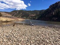
Cut bank is the steep bank/wall the faster side of the current is cutting into. Deposition bank is that gentle slope down to the inside bend and the gentler side of the river that the current is dropping material on during high water.
ImageUploadedByTreasureNet.com1490887378.001732.jpg
Cut bank on right of river, deposition on left including the cobble bar we are standing on.
 

Last edited:

Ragnor

Sr. Member
Dec 7, 2015
445
422
Primary Interest:
All Treasure Hunting
Almost all streams run on faults. The dip of the fault is going to dictate the angle of the stream bed and the canyon wall as is the alteration material along the contact surface. Bedding planes from different lava and pyroclastic flows and lahars will cut at different rates also. But generally every turn and dip in the creek represents a contact zone. At least in the area I live. I can see in some places surface geology would dictate stream beds. But them ain't the kind with steep sides........ usually. When a lava flow runs into a hillside your gonna get a strike from the hillside as it existed and then you are gonna get the relatively horizontal strike of the more recent flow. In general most of all the recent flows are basaltic in nature. Basalt cracks easily and erodes more rapidly than cemented or fused conglomerate from lahars or plutonic rocks that formed from andesite or diorite at depth. Those last two were formed under more pressure , so they are harder to erode. In some places the older rocks are much more brittle from oxidation and radio decay and or acids. They will also erode faster than a fresher andesite or diorite lava flow. I dunno if any of that makes sense, but that's my thoughts on the matter, lol

And Then.......

I completely left off the part about glaciation. Where a big old train of ice comes down over the ridge scraping off the canyon wall like a great big cheese grater.
 

Last edited:

Top Member Reactions

Users who are viewing this thread

Top