Strange circular objects in SoCal desert Mountains??

bobinsd

Sr. Member
Oct 20, 2005
491
250
San Diego California
Detector(s) used
Bounty Hunter
Primary Interest:
All Treasure Hunting
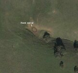
While Googling the mountains and desert east of San Diego and just north of the Mexican border, I spotted this figure 8 on the side of a mountain far from any civilization. As far as I can calculate, they are about 13 feet in diameter and are too perfect to be natural formations. Can any body offer a suggestion?

I'm not sure how to copy a GE image so the coordinates are....32 38 25.80N 116 03 30.11W
 

Old California

Full Member
Jul 16, 2006
221
18
Central California
I checked goggle earth with the site you're sharing with us and seen the figure eight, It looks like a man made structure (rock corral?)

Several years ago, I was searching for man made structures of California mission era using Goggle earth and came across this rock corral and rock wall looping around the bottom portion of the corral. It's situated near Soap lake and those that know the history of this area will know which area I am talking about, It's a short hike off the old early road used by the Indians and Spanish just never made the time to hike in.

Please do share with us when you find out what created the figure eight, Sounds very interesting and it may be from 150-200 years ago.

I'll attach a pic of the rock corral I came across on goggle, Maybe some day will get permission from the property owner and hike in for a looksee.

Paul (Ca)
 

Attachments

  • 5a.JPG
    5a.JPG
    37.3 KB · Views: 1,568

Tom_in_CA

Gold Member
Mar 23, 2007
13,837
10,360
Salinas, CA
🥇 Banner finds
2
Detector(s) used
Explorer II, Compass 77b, Tesoro shadow X2
Paul, and Bob-in-SD, I have tried, as you guys are, to use google sattelite photos for random searches in areas I'm researching. Invariably though, random shapes (even if seemingly symmetric, etc...) usually always turn out to be something innocuous. Something, for example, that seems square, turns out to be nothing but a modern dirt dike, or something round turns out to just be the ring of a dried up seasonal pool, etc...

Or put another way: Take some sites you actually already know of (foundations in the middle of no-where, adobe melt, lone chimneys out in the country, or whatever), and google-satellite zoom in on those: Ask yourself honestly: if you were just randomnly flying around via computer satellite (which isn't very focused or zoomed in), would you have honestly seen anything out of the ordinary there? I have tried, on many sites that I have done well at (reales, buttons, seateds, etc...) and can honestly say, the google satellite would have been of no help. Yes of course, now that I *already* know of the site, only THEN does the out-of-place shadows or shapes or whatever make sense.

Paul, as for Soap (aka San Filepe) Lake: I gave a talk, a few years ago, to the San Jose metal detecting club about mission era finds, sites, etc.... Afterwards, a fellow came up and said he'd detected at the site of a stone corral, way back in the back country of Henry Coe Park (or perhaps he meant, beyond their boundries back in the middle of nowhere, which would put him north of Hwy 152, eh?). He got some gun parts, buttons, a spur, etc... of the mission era. He had some sort of friend who ranched back there, who had clued him in, and taken him to this site. He & I were gonna team up and make another hike back in there, but he didn't seem to aggressive, so I never pushed it, and promptly forgot about it. As for the rancho and adobe at Soap Lake, all citations I have read about it, say the site of the actual adobe is un-known. One would think it wouldn't be too far from the lake of the name, nor too far off the travel route (which roughly follows the modern highway, eh?). I have studied every likely spot coming and going along there, ad-nauseum. Seems like every good spot, that might have been used in historical times, is built on (as there are modern homes dotting along that road). But anything's possible. As you know, sometimes where they put adobe sites, was the not same rationale for choosing a site, as the rationale for choosing wooden home/western sites.

At the Fisher museum, amongst their various finds displays, is some seated coins and such, with a caption "found near Soap Lake, CA". I asked the lady at the desk about that. Ie.: "who found this?" etc... It didn't seem like she knew or cared, as perhaps it way predated her (nor would they have probably divulged anonymous donors anyhow ::) )
 

Old California

Full Member
Jul 16, 2006
221
18
Central California
Hey Tom,

Thanks for jumping in, With your experience of this particular area and what you're saying this rock corral near Soap lake just may be the same adobe site that fellow was telling you about, I shared this with El about two years ago well actually pointed out the area up in the hills were this stone corral is located and yes it's North of 152.

The lost adobe of Rancho Tequesquite may be in this general area, Or maybe it's Rancho Ausaymas you're thinking about and if one can locate either one of the two adobe sites just may be able to get a nice assortment of relics/reales from mission era times including later early American coins from the 1850's since this old road was well traveled beyond mission era times..

Anyway, I'm sort of got my detecting arm tied up with priorities at the moment and won't be seriously free until early fall. May be able to sneak out a couple of times in-between then but for the most part pretty much have a full plate.

See you before the year end, Got to squeeze in a hunt or two before 2010 :)

Paul (Ca)
 

Tom_in_CA

Gold Member
Mar 23, 2007
13,837
10,360
Salinas, CA
🥇 Banner finds
2
Detector(s) used
Explorer II, Compass 77b, Tesoro shadow X2
Paul, you say: " .....may be the same adobe site that fellow was telling you about... " Actually, he hunted a corral site, not an adobe site. And from what I recall, it was way in-land, approached from Henry Coe park area (may have even been inside the bounds of the park, but I don't recall). So unless your site near soap lake is WAY north of Hwy. 152, I wouldn't think we're talking about the same spot. In any case, as I was saying, there are endless shapes and anomolies seen on satellite, that ...... once you get out there .... invariably turn out to be nothing but naturally explained phenomenoms, modern man-made whatz-itz in the earth, etc....

I am studying the books you sent me. I'll be making a hike into you-know-where within the next month or so :thumbsup: I think the spring grasses will be beat down low enough by now, to allow the coil to be swung in those hilly grass-lands.
 

OP
OP
bobinsd

bobinsd

Sr. Member
Oct 20, 2005
491
250
San Diego California
Detector(s) used
Bounty Hunter
Primary Interest:
All Treasure Hunting
This is the same area (a few miles away) that the petroglyph of the (Viking?) ship is found. If it is a corral, it is out of place, since this area has not seen flowing water for 300-400 years, perhaps longer. Plus the wall of the 13' diameter circle would be about 2-3 feet thick, leaving little space inside. It is unclear if these are 2 separate objects overlapping or are of a single figure 8-shaped enclosure, like 2 adjoining rooms. Has any indian culture ever buit such an abode? If there was a roof, it would have long ago disintegrated, leaving the walls visible. Perhaps a burial room? Can any one copy the site to Tnet...I don't know how?
 

Old California

Full Member
Jul 16, 2006
221
18
Central California
Bob,

Here's a picture of the circular walls you found on Satellite, I used the google measuring feature and found each circular room about 11-12' feet across, The inside of each room is (6-7' feet) which is much less due to the thickness of the wall....Both circular walls/rooms combined measured from the outside are about 22-24' feet across.

Appears to be a building structure below the hill which is about 35 yards from the twin circular stone rooms, And other circular stone rooms appear near the larger two on the same hill.

I don't know, They may be natural but are too perfect and who knows may be two stone corrals used as rooms?

Also, I don't think they would be adobe, Adobe would have washed away by now without the protection of a roof.

Plus, I'll enclose an actual 1860's adobe structure melted back into the earth taken from google. The adobe isn't that old and without a good roof intact the hard elements will eventually wash away the adobe walls.

Tom may recolonize this site we hunted years ago, Late 1850's site out in the middle of nowhere.

Please keep us posted if and when you find out what the circular objects are, If anything as least it sharpened your research skills.

(Tom) Yeah! That stone corral the fellow mentioned to you places it too far North of the one I was thinking about, His is about 5-7 miles North of the one near Soap Lake. Plus, Told you those books are packed with great info :) If you need help or information next time you're in my area let me know, May be able to get out and detect with you, The winter/spring grass should be baked down by now.

Paul (Ca)
 

Attachments

  • 6a.JPG
    6a.JPG
    48.2 KB · Views: 1,190
  • 7a.JPG
    7a.JPG
    5.6 KB · Views: 1,542

Tom_in_CA

Gold Member
Mar 23, 2007
13,837
10,360
Salinas, CA
🥇 Banner finds
2
Detector(s) used
Explorer II, Compass 77b, Tesoro shadow X2
Re.: the "figure 8" Bob-in-SD initially posted about: Paul, is that what you posted a pix of? (I haven't plugged in Bob's coordinates). If so, I don't see how that is a "figure 8". Nor does it have any rhyme or reason shape that I can make out. :dontknow:

Paul, yes, once a person KNOWS of a site (actually been there, hunted it, and pulled out period targets, etc...), then yes, only then does a shape or shadow on satellite makes sense. But if you ask yourself honestly "could I have discerned that shape from any other blur, shadow, line, curve, splotch, etc... randomnly across the landscape?" I think the answer would be "no". I have tried this with many sites where I've pulled reales from, all over the central coast, and have to admit that, if I hadn't previously known about the site, the satellite wouldn't have helped.

Yeah, I guess hiking out to known blotches or shapes is at least a start (as opposed to blind hiking), eh?
 

Old California

Full Member
Jul 16, 2006
221
18
Central California
Bob, As I mentioned earlier hope you can share more on the circular 8 if something does materialize from it.

Tom, I agree with you it's much easier to find man made objects from satellite if one knows a site was there. Otherwise, it's like trying to find a needle in a haystack randomly checking satellite photos searching for remains of an old site. But, Sometimes that needle in the haystack will surface.

Below, Is another satellite photo I just pulled and a picture of the same location from my 1892 County Atlas. It is an old stone corral from my area in the foot hills dating in the era of 1860-70, If memory serves me right I think a sheep Herder put up the stone corral. Later, A famous gun fight took place here well actually it was the last gun fight of Tulare County thus leaving the name (Stone Corral).

It's much larger than a normal size Rock/Stone corral, The length spans 87' by 74' feet in width. The wall thickness varies between 1' too almost 2' feet, With a front hall way type of entrance.

Amazing thing is this man made stone corral still stands today, Minus the smoke from the rifles and pistols of course :)

Paul (Ca)
 

Attachments

  • 6a.JPG
    6a.JPG
    70.4 KB · Views: 1,203
  • 5a.JPG
    5a.JPG
    40.3 KB · Views: 1,109

darthoblio

Full Member
Jun 19, 2010
114
20
Hi, new member and first post. I am in northern San Diego County and have discovered many anomalies in the area using Google Earth. I believe the area you're looking at could be an ancient structure, but remember it's at the bottom of a wash, which could get completely destroyed in one of the rare desert rains. So if there was something there, it probably wasn't there for long.
 

TerryC

Gold Member
Jun 26, 2008
7,735
10,996
Yarnell, AZ
Detector(s) used
Ace 250 (2), Ace 300, Gold Bug 2, Tesoro Cortes, Garrett Sea Hunter, Whites TDI SL SE, Fisher Impulse 8, Minelab Monster 1000, Minelab CTX3030, Falcon MD20, Garrett Pro-pointer, Calvin Bunker digger.
Primary Interest:
Metal Detecting
Bobinsd,
The thing(s) you are looking at are two conifers, side by side. They are lighter than the surrounding vegetation, as conifers usually are. The pic was taken at noonday, as evidenced by the shadows, showing the conifers are taller than the surrounding vegetation. The ultimate proof would be a walk-in by a local Tnetter. TTC
 

TerryC

Gold Member
Jun 26, 2008
7,735
10,996
Yarnell, AZ
Detector(s) used
Ace 250 (2), Ace 300, Gold Bug 2, Tesoro Cortes, Garrett Sea Hunter, Whites TDI SL SE, Fisher Impulse 8, Minelab Monster 1000, Minelab CTX3030, Falcon MD20, Garrett Pro-pointer, Calvin Bunker digger.
Primary Interest:
Metal Detecting
Here is a pic of the same area with a morning sun. The shadow area has moved to the left... indicating the morning sun. They are pines... taller than the surrounding area. TTC
 

Attachments

  • netmapwrapper_3_direct.jpg
    netmapwrapper_3_direct.jpg
    34.6 KB · Views: 807

TerryC

Gold Member
Jun 26, 2008
7,735
10,996
Yarnell, AZ
Detector(s) used
Ace 250 (2), Ace 300, Gold Bug 2, Tesoro Cortes, Garrett Sea Hunter, Whites TDI SL SE, Fisher Impulse 8, Minelab Monster 1000, Minelab CTX3030, Falcon MD20, Garrett Pro-pointer, Calvin Bunker digger.
Primary Interest:
Metal Detecting
Customx_12 said:
Any updates on this?
Custom, I believe it is time to solve this one once and for all.... mostly because I'm curious. I will break out the GPS and maybe one of the quads and GO FOR IT! I am assuming, though, that the area is publick and accessible. TTC
 

Customx_12

Hero Member
May 22, 2008
547
305
Detector(s) used
Tesoro Silver uMax
Primary Interest:
All Treasure Hunting
TerryC said:
Customx_12 said:
Any updates on this?
Custom, I believe it is time to solve this one once and for all.... mostly because I'm curious. I will break out the GPS and maybe one of the quads and GO FOR IT! I am assuming, though, that the area is publick and accessible. TTC

I'm excited to see what you find! Good luck and be safe!
 

TerryC

Gold Member
Jun 26, 2008
7,735
10,996
Yarnell, AZ
Detector(s) used
Ace 250 (2), Ace 300, Gold Bug 2, Tesoro Cortes, Garrett Sea Hunter, Whites TDI SL SE, Fisher Impulse 8, Minelab Monster 1000, Minelab CTX3030, Falcon MD20, Garrett Pro-pointer, Calvin Bunker digger.
Primary Interest:
Metal Detecting
Customx_12 said:
Any updates on this?
SUCCESS!!!! Google Earth has updated the area sat photos. A VERY good resolution pic is now beiing shown. The two "corrals" are now no doubt trees... probably conifer... but maybe broadleaf. The "structure" below the trees is now clearly a boulder. My measurement indicates the boulder to be about 7 meters across. No field attempt will be made by me. I would include the GE photo but I don't know how.Thanks. TTC
 

Customx_12

Hero Member
May 22, 2008
547
305
Detector(s) used
Tesoro Silver uMax
Primary Interest:
All Treasure Hunting
TerryC said:
Customx_12 said:
Any updates on this?
SUCCESS!!!! Google Earth has updated the area sat photos. A VERY good resolution pic is now beiing shown. The two "corrals" are now no doubt trees... probably conifer... but maybe broadleaf. The "structure" below the trees is now clearly a boulder. My measurement indicates the boulder to be about 7 meters across. No field attempt will be made by me. Thanks. TTC

Which is initially what you thought it was, right? A little bit of a let down that it isn't riches beyond our wildest dreams, but thanks for the info!
 

TerryC

Gold Member
Jun 26, 2008
7,735
10,996
Yarnell, AZ
Detector(s) used
Ace 250 (2), Ace 300, Gold Bug 2, Tesoro Cortes, Garrett Sea Hunter, Whites TDI SL SE, Fisher Impulse 8, Minelab Monster 1000, Minelab CTX3030, Falcon MD20, Garrett Pro-pointer, Calvin Bunker digger.
Primary Interest:
Metal Detecting
Customx_12 said:
TerryC said:
Customx_12 said:
Any updates on this?
SUCCESS!!!! Google Earth has updated the area sat photos. A VERY good resolution pic is now beiing shown. The two "corrals" are now no doubt trees... probably conifer... but maybe broadleaf. The "structure" below the trees is now clearly a boulder. My measurement indicates the boulder to be about 7 meters across. No field attempt will be made by me. Thanks. TTC

Which is initially what you thought it was, right? A little bit of a let down that it isn't riches beyond our wildest dreams, but thanks for the info!

Yes, I thought it was conifers. I have done this kind of research many times. Really doesn't change except high resolution imaging really helps. My earlier posts sounded a little too "high brow". For that, I am sorry. TTC
 

Top Member Reactions

Users who are viewing this thread

Top