hiker, Kinniconick Creek, Lewis County, KY, had wrong spelling
You are using an out of date browser. It may not display this or other websites correctly.
You should upgrade or use an alternative browser.
You should upgrade or use an alternative browser.
Swift and the Waybill
- Thread starter Curtis
- Start date


KY Hiker
Bronze Member
- Oct 28, 2014
- 1,537
- 3,220
- Detector(s) used
- Whites
- Primary Interest:
- All Treasure Hunting
hiker, Kinniconick Creek, Lewis County, KY, had wrong spelling
Thank you.
I think this is the area you are referring to?
Looks like Silver Lick Hollow, Burnt Cabin Branch and Paint Lick are the drains....
https://www.topoquest.com/map.php?l...nad83&zoom=8&map=auto&coord=d&mode=pan&size=m
Last edited:
hiker that's it, silver lick not silver run. forgot to tell you that across from the mouth of burned cabin branch is the end of a ridge that comes to a point. walking from the end of that ridge south. watch for different size rock halfway up on the hill side. it looked like a mine cave-in. I think it was about 1/8 mile to it. going south to headwaters, laurel fork has rose and white quarts 2 of the rose had vary small bits of gold in it, but the flaks had like a brown green ting.
KY Hiker
Bronze Member
- Oct 28, 2014
- 1,537
- 3,220
- Detector(s) used
- Whites
- Primary Interest:
- All Treasure Hunting
So....if this area is a possible Swift location it would not fit the directions given in the journal for the rich mines. This area (Kinniconick Creek) would be NW of the little Caney Creek area, and not SW as described by many versions of the journal. SW would take you in the general direction of Campton and Beattyville.....
Although, Kinniconick Creek would fit within the French (Frenchburg) region of mining operations?
Although, Kinniconick Creek would fit within the French (Frenchburg) region of mining operations?
Last edited:
Brushy Bandit
Full Member
I've heard that there was a Rock bridge at the line of rock, have you been able to find anything definite on it? I've tried many sources, even talk in to people that worked on the construction of the Grayson Lake, but have not been able to nail that down for sure.
1320
Silver Member
So....if this area is a possible Swift location it would not fit the directions given in the journal for the rich mines. This area (Kinniconick Creek) would be NW of the little Caney Creek area, and not SW as described by many versions of the journal. SW would take you in the general direction of Campton and Beattyville.....
Although, Kinniconick Creek would fit within the French (Frenchburg) region of mining operations?
Frenchburg received it's name from Robert French, a local lawyer. He wasn't French....lol
KY Hiker
Bronze Member
- Oct 28, 2014
- 1,537
- 3,220
- Detector(s) used
- Whites
- Primary Interest:
- All Treasure Hunting
I've heard that there was a Rock bridge at the line of rock, have you been able to find anything definite on it? I've tried many sources, even talk in to people that worked on the construction of the Grayson Lake, but have not been able to nail that down for sure.
I thought someone posted a C.C.C. source of the bridge dimensions...seemed real high and narrow and I thought it was in the Carter Caves area....smoke valley?
Here is the thread that has it;
http://www.treasurenet.com/forums/lost-silver-mines-jonathan-swift/530130-swift-silver-15.html
There is an attachment titled 'Natural Bridge' with dimensions.... and compares it to Rock Bridge on Swift Camp Creek. Seems too high to me to be real....
Last edited:
KY Hiker
Bronze Member
- Oct 28, 2014
- 1,537
- 3,220
- Detector(s) used
- Whites
- Primary Interest:
- All Treasure Hunting
Frenchburg received it's name from Robert French, a local lawyer. He wasn't French....lol
Interesting, I never heard of that...WTH would a town name itself for a lawyer for? Isn't there an area up towards Frenchburg called the sinks? That was a possible mining location in pre-pioneer days?
Last edited:
1320
Silver Member
Interesting, I never heard of that...WTH would a town name itself for a lawyer for? Isn't there an area up towards Frenchburg called the sinks? That was a possible mining location in pre-pioneer days?
Nearly every city, town, place in Kentucky is named after an individual.
Frenchburg has been on the John Swift radar for many years, Boomer did some kicking around there in the past. I don't know about the Sinks however, I have seen two rock shelters that had some form of mining conducted in them. I have no idea what was being mined. Salt Peter could be obtained by leaching so no drilling needed for that. Coal is a possibility but no evidence of coal in the shelters I'm referencing. One of the shelters is comprised of mainly sandstone, I have no idea what those folks would have been after.
Frenchburg was named after a lawyer because he could read and write. the sinks, that was a large hill at one time and because it was lime stone collapsed in on itself forming the sink. Vern Spratt who owned the place showed me a hole in the lowest part of the sinks that had chisel marks along the sides going downward for 8 feet, but that's has far as I got. blocked by large limestone pieces.
remember beaver creek at frenchburg was used to make the fake map in swift book, for years I wondered why he would chuckle when I asked about the swift map. then I saw the map of the beaver creek iron company holdings around frenchburg and it matched the swift map, except someone had removed some of the creek lines.
has for the line of rock, if you look at the aerial photos before the dam was put in, you can see the large rocks laying across the sand where the arch should be.
at carter caves state park back when you could use a detector I found some slag down at creek level, in front of bat cave. the dry creek bed curved around like a U shape. where did all this slag come from, no idea? i searched the whole back end. put slag in reheat furnace at work and got drops of pure silver out of it. I know that several groups work silver around there. some were put in jail. but where were they getting the ore? look at a map of carter caves over to Lewis county, there seems to be a kind of line or a fault running there? Go on carter caves road at the end is route 2, before getting to rt. 2 there is a small valley on your right. at the back side is a small drain, with a silver/lead mine there. one at carter city, one west of Boone furnace and of course kinnie creek in Lewis county. almost forgot, there is a vary large rock bridge at carter caves, just walk toward bat cave and there it is.
Brushy Bandit
Full Member
I thought someone posted a C.C.C. source of the bridge dimensions...seemed real high and narrow and I thought it was in the Carter Caves area....smoke valley?
Here is the thread that has it;
http://www.treasurenet.com/forums/lost-silver-mines-jonathan-swift/530130-swift-silver-15.html
There is an attachment titled 'Natural Bridge' with dimensions.... and compares it to Rock Bridge on Swift Camp Creek. Seems too high to me to be real....
I am meaning a Rock bridge on Caney at line of rocks, not Smokey bridge or any bridges at Carter caves. Apples and oranges
KY Hiker
Bronze Member
- Oct 28, 2014
- 1,537
- 3,220
- Detector(s) used
- Whites
- Primary Interest:
- All Treasure Hunting
I am meaning a Rock bridge on Caney at line of rocks, not Smokey bridge or any bridges at Carter caves. Apples and oranges
Sorry, I just have in the back of my mind the fact that there is currently only one actual Rock Bridge over a named stream in KY. Whenever I hear of another I just can't picture it, even though there could have been multiple bridges in the past, I guess its because of the context of time.
KY Hiker
Bronze Member
- Oct 28, 2014
- 1,537
- 3,220
- Detector(s) used
- Whites
- Primary Interest:
- All Treasure Hunting
Frenchburg was named after a lawyer because he could read and write. the sinks, that was a large hill at one time and because it was lime stone collapsed in on itself forming the sink. Vern Spratt who owned the place showed me a hole in the lowest part of the sinks that had chisel marks along the sides going downward for 8 feet, but that's has far as I got. blocked by large limestone pieces.
remember beaver creek at frenchburg was used to make the fake map in swift book, for years I wondered why he would chuckle when I asked about the swift map. then I saw the map of the beaver creek iron company holdings around frenchburg and it matched the swift map, except someone had removed some of the creek lines.
has for the line of rock, if you look at the aerial photos before the dam was put in, you can see the large rocks laying across the sand where the arch should be.
at carter caves state park back when you could use a detector I found some slag down at creek level, in front of bat cave. the dry creek bed curved around like a U shape. where did all this slag come from, no idea? i searched the whole back end. put slag in reheat furnace at work and got drops of pure silver out of it. I know that several groups work silver around there. some were put in jail. but where were they getting the ore? look at a map of carter caves over to Lewis county, there seems to be a kind of line or a fault running there? Go on carter caves road at the end is route 2, before getting to rt. 2 there is a small valley on your right. at the back side is a small drain, with a silver/lead mine there. one at carter city, one west of Boone furnace and of course kinnie creek in Lewis county. almost forgot, there is a vary large rock bridge at carter caves, just walk toward bat cave and there it is.
I tried to do a lawyer joke, it didn't work.... What you describe as the sinks sounds familiar. One branch of Chimney Top Creek in the Red River Gorge was a collapsed cave system, its funny, its head waters are on the opposite side of a ridge from where Timmin's claimed she had found Swift's mine on Swift Camp Creek. Strange how the geology periodically repeats. Silver slag at Carter Caves ? So Boomer, silver deposits were (past tense) fairly common throughout the state from your findings? Was the rock bridge near Bat cave over water?
1320
Silver Member
Frenchburg was named after a lawyer because he could read and write. the sinks, that was a large hill at one time and because it was lime stone collapsed in on itself forming the sink. Vern Spratt who owned the place showed me a hole in the lowest part of the sinks that had chisel marks along the sides going downward for 8 feet, but that's has far as I got. blocked by large limestone pieces.
remember beaver creek at frenchburg was used to make the fake map in swift book, for years I wondered why he would chuckle when I asked about the swift map. then I saw the map of the beaver creek iron company holdings around frenchburg and it matched the swift map, except someone had removed some of the creek lines.
has for the line of rock, if you look at the aerial photos before the dam was put in, you can see the large rocks laying across the sand where the arch should be.
at carter caves state park back when you could use a detector I found some slag down at creek level, in front of bat cave. the dry creek bed curved around like a U shape. where did all this slag come from, no idea? i searched the whole back end. put slag in reheat furnace at work and got drops of pure silver out of it. I know that several groups work silver around there. some were put in jail. but where were they getting the ore? look at a map of carter caves over to Lewis county, there seems to be a kind of line or a fault running there? Go on carter caves road at the end is route 2, before getting to rt. 2 there is a small valley on your right. at the back side is a small drain, with a silver/lead mine there. one at carter city, one west of Boone furnace and of course kinnie creek in Lewis county. almost forgot, there is a vary large rock bridge at carter caves, just walk toward bat cave and there it is.
Mr. French would get a kick out of your internet spelling and punctuation (or lack thereof)......lol.
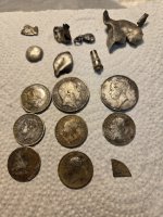
Hiker: from souvenir store follow sign to bat cave. creek goes out of cave near store and goes toward bat cave. the rock bridge is about 100 yards from bat cave. its about 200 feet high. 40 to 60 feet wide and has a 2 lane road running across it. arch looks to be 50 feet thick. do not remember if Boones grand son or son was the high sheriff of greenupsburg, but they put a few of the counterfeiter's away. greenup county library has some old records of bags of coins and silver bars being confiscated.
OP
OP
Curtis
Hero Member
- Thread starter
- #36
Boomer mentioned that it Is a mystery of where the counterfeiters got their ore. I found an old furnace remains off of a ridge not far from the old Stampher farm where the Lekaine treasure was supposed to be... that isn't too far from Carter Caves as the crow flies, also found a vein that runs the ridge for about 2 miles. Had a assayer look at some samples he said silver was good for a large scale commercial operation, but the amount of platinum was really high and he wanted to get people on to it. Sounds good but I don't own any property in KY.
OP
OP
Curtis
Hero Member
- Thread starter
- #37
 Somethings are hard to accept, like the cross on its side here..Spanish sign that the treasure is located were the long end of the cross is pointing. I had to repel down to get to it and it ended up being a natural formation not carved! But its only 500 yards from the last Indian Waybill mine, so I was sure it was related.
KY Hiker
Bronze Member
- Oct 28, 2014
- 1,537
- 3,220
- Detector(s) used
- Whites
- Primary Interest:
- All Treasure Hunting
I would have suspected the horizontal line to be natural but not the vertical of the cross by just looking at the other seams in the rock.
OP
OP
Curtis
Hero Member
- Thread starter
- #39
The photo was from about 10 feet away..when i saw it I was on a cliff about 50 feet away, had to let myself down by a rope, and that turned into a scary situation, lots of bear poop around that area..and I couldn't get back up the rope ..it was a lot harder getting out! but I manged to do it with the Lord's help!
KY Hiker
Bronze Member
- Oct 28, 2014
- 1,537
- 3,220
- Detector(s) used
- Whites
- Primary Interest:
- All Treasure Hunting
Its really not a good idea to do that kind of stuff solo, I hope you had/have a partner when your out.
Users who are viewing this thread
Total: 3 (members: 0, guests: 3)