The Butterfield Trail and the service of the Overland Mail Company (its official designation) in Arizona only existed from September 1858 to March 1861. The trail was 400.74 miles long in Arizona.
No Butterfield stagecoach was ever robbed by outlaws in Arizona. Once it was attacked and only delayed by Indians and that was at Apache Pass in February 1861 because of the Bascom affair. The instructions to the Buttefield employees was that the company nor the passengers was to carry any valuables on the stagecoaches. Outlaws would have no reason to hold up the stages.
There is a great deal of misinformation about the stage stations in Arizona. There were a total of twenty-six during the service of Butterfield with seventeen at the beginning and twenty-five at the peak in October 1860. Wikipedia has many errors concerning the subject. I stopped counting at twenty-five and gave up. The stations they list are taken from the highly inaccurate list made by Bailey who was on the first Butterfield stagecoach through Arizona to make an inspection for the Postmaster General. He misspelled many of the names and made only a rough estimate of the distances between stations. Thirteen of the station sites are on private land and the other thirteen are on Federal, State, and Indian Nation land.
There is only one identifiable Butterfield station ruins and that is the protected site of Dragoon Springs Stage Station. After Butterfield was ordered to close the line in March 1861, because of the advancing Confederate Army, the Confederates burned some of the stations and then the Apaches burned some because the thought they had won and driven the Americans from the territory. In the Western half of the State many of the stations near the Gila River were destroyed because of the great flood of 1861-62. The deep sand created by this flood and many others has covered some of the station sites in deep sand.
There are many contemporary buildings or ruins in Arizona that claim to have been Butterfield stations. None are true except for the ruins at Dragoon Springs. Photos are often shown of stage stations on what was the Butterfield Trail but these are later ones after Butterfield, some built on or near the old Butterfield site. After Butterfield closed in 1861 stage lines were not started up again until late in the 1860s. Some mail was carried by mule or horseback and this has sometimes mistakenly claimed to have been the Pony Express. There was no Pony Express along the Butterfield Trail
Another interesting misconception is the number of stagecoaches at tourist sites in Arizona that are represented as being old Butterfield stagecoaches. They are not. No Concord or Troy style stagecoaches were used by Butterfield in Arizona. Only the Celerity stagecoach was used. And besides, Butterfield was ordered in March 1861 to move all livestock, employees, and equipment to the central line.
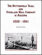
My first book on the trail in Arizona was "Retracing the Butterfield Overland Trail through Arizona" that was published in 1973. This was nothing more than an atlas. In my new book published April 2011 titled "The Butterfield Trail and Overland Mail Company in Arizona, 1858-1861" I have set all contemporary references aside. In my research for this book, I researched, almost exclusively, government published reports from the period, first hand accounts by newspaper correspondents that traveled on Butterfield stagecoaches, and military reports. I have over ninety maps in the book showing its entire route across Arizona as well as many photographs. It also contains many GPS locatons. The information in the book as well as the body of the GPS determined by me are copyrighted and cannot be republished without my permission. I have written this book to preserve the history of the trail as to help protect what remains of the physical ruts of the trail.


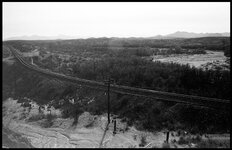
 ? It has been a while since I have been back in that area, but it is some beautiful country. The bridge that spans the Cienega Creek Reclaimation Project is an amazing spot as well, and good exploring down below it along the creek, well minus the Bears and Mountain Lions that have moved into the area.