The Sphinx of the Grand Canyon

Springfield

Silver Member
Apr 19, 2003
2,850
1,383
New Mexico
Detector(s) used
BS
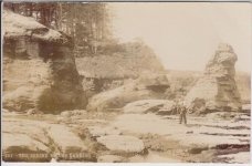
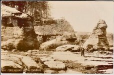
Well, Double E, for those who think the old photo shows a carved sphinx at the top of the butte, the only recourse would be to identify the proper hill, then climb up there and inspect the area. I believe they'll find nothing more than natural features when they arrive on site, wherever it may be, but you never know. This takes a strong belief, not just an off-the-hip conclusion, and I doubt it'll happen. I've been halfway up Isis myself, back in the '70's, and I assure you it's not a stroll in the park.

Like I said, I'm not married to Isis Temple as the butte in the old photo, but until someone comes up with a better option, I'll hold. As far as the Kincaid location is concerned, if there really was such a place discovered in the early 1900's, then based on what I've read (years ago by now, granted), Marble Canyon would be where I would start. I believe the Grand Canyon may hold profound secrets, but their locations may well be impossible to find without prior knowledge. I once spent an entire week very far off-trail in side canyons that very few people visit and barely put a drop of water in a swimming pool of possibilities. They say the cops are restricting travel in much of the canyon now - if so, that's too bad.
 

EE THr

Silver Member
Apr 21, 2008
3,979
38
Central California
I don't think it's possible to tell if any features on whatever the Sphinx photo is, are natural or man made, just from that photo itself.

All I'm saying is what I see in those photos.

It seems very strange that the "Sphinx" has never been found since then, too.

:icon_scratch:
 

OP
OP
Shortstack

Shortstack

Silver Member
Jan 22, 2007
4,305
416
Detector(s) used
Tesoro Bandido II and DeLeon. also a Detector Pro Headhunter Diver, and a Garrett BFO called The Hunter & a Garrett Ace 250.
Primary Interest:
All Treasure Hunting
Thanks for the link, Okey Dokey. It's now in my bookmarks. The stories reported there have believers and detractors galore. The Smithsonian later claimed that they were not involved in that project and said they didn't know who this Mr. Jordan was. After that comment was released, some wonder if that guy was leading a big treasure recovery team who were using the Smithsonian as a cover because they'd gambled that no one would bother double checking their story. In those days, communications from Arizona to the D.C. area would have taken days to complete.
 

EE THr

Silver Member
Apr 21, 2008
3,979
38
Central California
The Grand Canyon, being so deep, could be the oldest inland waterway on the Continent, or maybe the World.

The depth the water has cut, would depend on the hardness of the surface under it, and how long it has been flowing, right?

Is the earth below it significantly softer than rivers elsewhere?

Is there another "grand canyon" anywhere else on the planet?

Just thinking out loud....


:coffee2:
 

OP
OP
Shortstack

Shortstack

Silver Member
Jan 22, 2007
4,305
416
Detector(s) used
Tesoro Bandido II and DeLeon. also a Detector Pro Headhunter Diver, and a Garrett BFO called The Hunter & a Garrett Ace 250.
Primary Interest:
All Treasure Hunting
EE:
I've seen presentations that point to the possibility that the Grand Canyon was cut in a matter of days and not millions of years due to the actions of a great inland sea that was dammed up by the huge ridge that runs in an arc from Nevada down and across that northern corner of Arizona. A very good example of that action can be seen in the way earthen dams of lakes and ponds have been cut through in just a day. Scientists resist that idea because of the HUGE scale of the CG. That great scale would mean nothing to the equally great size of that inland sea. For the Colorado River to have cut through that area during millions of years would have required that river to have flowed UP HILL to cut that huge ridge.
I'm not trying to get my own thread off track. The FACT that the Grand Canyou has been around for thousands of years is not debated and the varying kinds of rocks that make up the various layers in the canyon is obvious. The first man to lead a team through the entire length of the Grand Canyon complex described some surprising differences. John Wesley Powell also described one particular area in the Marble Canyon stretch as having the appearance of man made architectural details. Those details were discovered after he and his second in command followed a well used and ANCIENT foot trail away from the river's edge, up and over a bench and a short walk into a small side canyon.
If I'm not mistaken, the Snake River Canyon has been referred to as "the OTHER Grand Canyon. No were near the SIZE, but due to the way it has cut deeply through varying layers of rock to give it some very steep sides. I would suspect that the closest thing to our Grand Canyon would the the Great Rift in Africa, but the Great Rift is not a deep cut canyon as the GC although it is BIG. :dontknow:
 

EE THr

Silver Member
Apr 21, 2008
3,979
38
Central California
Shortstack---

Thanks for typing all of that! ;D

I'm not sure if I vaguely remember something about that theory or not. There seems to be many possibilities that come up from time-to-time. Nevertheless, I guess it's possible.

One thing I can see, is that there are many levels at which the erosion stopped or slowed down, meaning the water level hit a hard layer, or was reduced in flow rate. Seeing that the next level downward is narrower, I would say that these various levels are due to a reduction in flow rate, every so often.

If erosion of the ridge that you mentioned, occurred in stages, rather than evenly, that could possibly make the different sharp levels. The only thing I can think of which would cause the ridge to erode in stages would be if it, itself, had alternating hard and softer layers.

The question would be: Where is the breakthrough, and does it have these alternating hard and soft layers, itself?

:coffee2:
 

OP
OP
Shortstack

Shortstack

Silver Member
Jan 22, 2007
4,305
416
Detector(s) used
Tesoro Bandido II and DeLeon. also a Detector Pro Headhunter Diver, and a Garrett BFO called The Hunter & a Garrett Ace 250.
Primary Interest:
All Treasure Hunting
I would believe that the breakthrough could have been anywhere along the width of the cut. The hard levels of stone would slow down the rate of erosion, but the loose material carried by the flood would act as a sandblaster to a certain point. As the level of flood waters went down, the width of the cut would have decreased in size also. Again, check into the way the cuts are formed in an earthen dam's breaching. When the cut is made quickly, the sides will collapse into the flood waters FROM THE TOP and add wear material to the waters to aid in the further cutting of the rift. If you look at the remains of a breached earthen dam, you'll see first off how wide the top of the cut is when compared to the bottom where the remaining water is running out.

Hey, I'm one of those Creation "nuts" so follow your own ideas. :laughing7: :thumbsup: :coffee2:
 

Saturna

Bronze Member
May 24, 2008
1,373
10
Nanaimo, B.C. Canada
Detector(s) used
White's 4900 DL Max, Tesoro Deleon
Here's another Sphinx, this one with a turtle beside it.

sphinx.jpg


Don't know where Briggs Landing is, but it looks like the west coast.
 

Saturna

Bronze Member
May 24, 2008
1,373
10
Nanaimo, B.C. Canada
Detector(s) used
White's 4900 DL Max, Tesoro Deleon
The one sitting up looks very bird like.

The one to it's right (just to our left of the tripod) looks turtle like, or maybe even a frog.
 

EE THr

Silver Member
Apr 21, 2008
3,979
38
Central California
Shortstack---

It appears that the entire Sacramento valley was a bay at one time, because of the surrounding rim that would hold water in. Well except for down toward the Salton Sea, there is an opening, which may account for the early maps which show California as an island (if they were based on Ancient knowledge).

So is there any corresponding "holding tank" rim which would account for the giant inland sea that could have broken through the plug formed by the ridge in Nevada?

I'm looking for a sign of the Nevada ridge on Google Earth, but not having much luck.

I'm just wondering, if there was this inland sea, why didn't it just empty into the Gulf, you know?
 

Springfield

Silver Member
Apr 19, 2003
2,850
1,383
New Mexico
Detector(s) used
BS
Shortstack said:
...... I would suspect that the closest thing to our Grand Canyon would the the Great Rift in Africa, but the Great Rift is not a deep cut canyon as the GC although it is BIG. :dontknow:

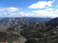
Barranca del Cobre, Chihuahua, Mexico. Four times larger than Grand Canyon, USA. Great train trip through it.
 

Attachments

  • Copper_Canyon_01.jpg
    Copper_Canyon_01.jpg
    184.2 KB · Views: 1,233
OP
OP
Shortstack

Shortstack

Silver Member
Jan 22, 2007
4,305
416
Detector(s) used
Tesoro Bandido II and DeLeon. also a Detector Pro Headhunter Diver, and a Garrett BFO called The Hunter & a Garrett Ace 250.
Primary Interest:
All Treasure Hunting
Thank you, Saturna, for this photo. I tried to cut out the fog look and refrained from marking any signs to prevent the great graffiti god from raining ruin and destruction down on this thread. LMFAO. I believe the free standing monument (?) on the right is the sphinx. That biggie in the middle has to be the turtle.
sphinx.jpg


Springfield:
That is a beautiful area in your photo. Thanks for sharing. Have you taken a train trip through there? Is it a long one or is it in only a short section of the canyon?

EE:
I need to download a photo from Google Earth and mark it up some. The Salton Sea in southere California use to be under water at one time. The mouth of the Colorado River was a lot further north of it's present location. That's one reason there are folks who faithfully believe in the Lost Ship of the Desert treasure tale. I have NEVER believed in the "melting glaciers cause a great flood" crap. Glaciers simply do not melt that quickly to cause such a large scale flood on the North American Continent. But, runoff from the Great Flood WOULD have formed HUGEMONGUS flood plains that can still be seen from satellite imagery.
 

Springfield

Silver Member
Apr 19, 2003
2,850
1,383
New Mexico
Detector(s) used
BS
EE THr said:
Springfield---

Is that four times longer, deeper, or in area?

Do you happen to know the water source?

Hmmm ... I'm not sure how they measured it. Seems like it's much longer and in some parts deeper than the Grand Canyon. The Rio Fuerte is the main river, but as I recall there are several other good sized rivers that empty into the Fuerte from the mountains along the way. The train runs all the way from Chihuahua City to Los Moches on the Gulf of California - about a 300-400 mile trip. I rode the train back in the '70's when things were still a little rough - I think the facilities are much improved now that the thing has become quite a tourist attraction.
 

EE THr

Silver Member
Apr 21, 2008
3,979
38
Central California
I'm also wondering if these huge river canyons are the result of only one cycle of large runoffs, or maybe more, over the ages?

Is there any way to tell?
 

Springfield

Silver Member
Apr 19, 2003
2,850
1,383
New Mexico
Detector(s) used
BS
EE THr said:
I'm also wondering if these huge river canyons are the result of only one cycle of large runoffs, or maybe more, over the ages?

Is there any way to tell?

In my opinion, the Grand Canyon was formed very, very quickly - not by slow, relentless erosion as the experts claim. Maybe after the Great Flood, maybe an earthquake, maybe after the Ice Age - who knows? One look at the place convinced me. Of course, I could be wrong.
 

EE THr

Silver Member
Apr 21, 2008
3,979
38
Central California
I wonder if there would be any way to determine the time frame, from what is there now? Maybe deposits of stuff on top of the different step-layers?

Or differences in exposure to sun and weather of the different layers?


:icon_scratch:
 

Top Member Reactions

Users who are viewing this thread

Top