Trail Signs and Monuments-Spanish or Somebody Else

OP
OP
M

mdog

Bronze Member
Mar 22, 2011
2,351
4,406
That "M and eye" is repeated a number of times around the country. So are other symbols, including the Egyptian-looking ones. This site has lots of photos. http://www.mysteryglyphs.com

You might be interested, dog, that an acquaintance of mine in Utah theorizes that many of the mystery glyphs derive directly from the Ojibwa tribe of the upper midwest. And, by inference, the connection is via the KGC. I recall that Terry Carter's YouTube channel has a couple of videos on the subject, but I didn't bookmark them.

You’ve been to the Silver City glyph, did anything catch your attention as to why that place might have been chosen?
 

OP
OP
M

mdog

Bronze Member
Mar 22, 2011
2,351
4,406
That "M and eye" is repeated a number of times around the country. So are other symbols, including the Egyptian-looking ones. This site has lots of photos. http://www.mysteryglyphs.com

You might be interested, dog, that an acquaintance of mine in Utah theorizes that many of the mystery glyphs derive directly from the Ojibwa tribe of the upper midwest. And, by inference, the connection is via the KGC. I recall that Terry Carter's YouTube channel has a couple of videos on the subject, but I didn't bookmark them.

I knew, when you mentioned the Ojibwa, that I had heard the name before. I read about them when I was doing all the map work on the Kensington Stone. Do you know what the connection was to the KGC? The Ojibwa had a secret society with some rites similar to the Masons. Also, Louis Osmer mentioned in Carter’s video that whoever carved the mystery glyph at Silver City had to have a real light touch with very sharp instruments. I believe Ojibwa means, those who carve stone. I think they carved in pipestone but I’m not sure.
 

sdcfia

Silver Member
Sep 28, 2014
3,661
8,894
Primary Interest:
Other
You’ve been to the Silver City glyph, did anything catch your attention as to why that place might have been chosen?

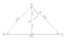
Yes, for its geographical position. It occupies point B in the 53 square-mile near perfect right triangle A-B-C below. Points A and C are unmistakable regional natural landmarks, themselves both heavily steeped in treasure legend. Interestingly, the interior right triangle A-D-E, a fractal of sorts, is formed by significant manmade things at D and E.

Many of the Mystery Glyph locations are in areas where significant treasure legends exist. If I knew more about the various sites, I'd be mapping their locations against known clues there. The one other site I do know a little about (Tempe AZ) also seems to be forming a similar right triangle with a couple of things associated with the Lost Dutchman legend. Trouble is, I don't have exact coordinates for the glyphs (close, but not exact) and I don't know enough about AZ or important LDM sites. Bottom line: I suspect the Mystery Glyphs are post Civil War at the earliest and link treasure signs in geometric patterns. One thing for sure, triangle A-B-C speaks for itself, whatever it's saying.

bigtriangle.jpg
 

sdcfia

Silver Member
Sep 28, 2014
3,661
8,894
Primary Interest:
Other
I knew, when you mentioned the Ojibwa, that I had heard the name before. I read about them when I was doing all the map work on the Kensington Stone. Do you know what the connection was to the KGC? The Ojibwa had a secret society with some rites similar to the Masons. Also, Louis Osmer mentioned in Carter’s video that whoever carved the mystery glyph at Silver City had to have a real light touch with very sharp instruments. I believe Ojibwa means, those who carve stone. I think they carved in pipestone but I’m not sure.

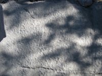
Osmer was right - whoever carved those glyphs was very highly skilled. Most of them are about 2" diameter in size, chiseled into a difficult hard and pitted limestone surface. Here's another fairly high-res shot of the panel that you can enlarge. Beautiful work.
IMG_6206.JPG

Allegedly, the Ojibwa were one of the Native American tribes that Jesse James brought into the KGC alliance. I guess I'll look into knowing more about them - another item on the list, ha ha. From the KGC lore, you might add the Sioux and Utes to the list too, but as you know the whole concept is unproven.
 

OP
OP
M

mdog

Bronze Member
Mar 22, 2011
2,351
4,406
Native stuff can be delved upon by locale.
Often ceremonial but also documenting things as they were perceived at the time. Using such sites as you mention as landmarks , certainly doable.
More , certain places were not to be approached. While others only with caution and sacrifices. Waters were seldom trusted. But necessary at the same time.
A spirit cave was safe from certain natives.
It's whereabouts known by others though meant a place things would be left alone. With exception of an occasional arrow launched from a distance.

From Agawa area. No treasure signs though. (?)
View attachment 1669994
https://albinger.me/2014/08/02/the-anishinaabe-rock-paintings-of-agawa-rock-a-quick-guide/

RC, here's a link that gives a history of the Ojibwa migration. Maybe you've seen it or even posted it before, but I thought our members might like it.

http://www.iiseagrant.org/catalog/downlds_09/Ojibway - Early Immigrants.pdf
 

releventchair

Gold Member
May 9, 2012
22,413
70,838
Primary Interest:
Other
RC, here's a link that gives a history of the Ojibwa migration. Maybe you've seen it or even posted it before, but I thought our members might like it.

http://www.iiseagrant.org/catalog/downlds_09/Ojibway - Early Immigrants.pdf

Have not seen that , thanks.
It does show the E-W (great lakes to East coast) water route through the St. Lawrence being used . One that Europeans would follow later.
Too , the migration routes show the natural tendency to follow terrains/waters. Delta's are often fertile and foods include both flora and fauna...

Article also mentions the major forces N and S (Anishinabi vs Iroquois) which after making peace with each other , would with other tribes be split again by European influence.

The first picture/drawing shows Great Lakes floral designs. Still worked today , but often as since post contact ; using seed beads.

Ottawa are noted as traders, confirming what we already knew. Though no mention of the fierceness with which their position was enforced..
 

Last edited:

PROSPECTORMIKEL

Silver Member
Mar 31, 2011
2,624
9,424
N/W ARKANSAS
Detector(s) used
FISHER
Primary Interest:
All Treasure Hunting
I am very impressed with the quality and the forms of information that have been posted here.

And I have to admit that I didn’t realize how much, in depth information that is readily available, and has already been posted here.

I wonder if I can keep up, at least well enough to contribute something of value, to the thread.

I have been skipping along, mostly hitting the the high points.

Thank you, to all who have shared links. Wow, so much to learn here.

Great thread, MDOG!

#/;0{>~
 

OP
OP
M

mdog

Bronze Member
Mar 22, 2011
2,351
4,406
I am very impressed with the quality and the forms of information that have been posted here.

And I have to admit that I didn’t realize how much, in depth information that is readily available, and has already been posted here.

I wonder if I can keep up, at least well enough to contribute something of value, to the thread.

I have been skipping along, mostly hitting the the high points.

Thank you, to all who have shared links. Wow, so much to learn here.

Great thread, MDOG!

#/;0{>~

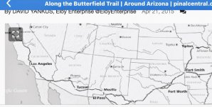
Thanks Mikel. Here's a trail that looks like it got pretty close to your area.

https://www.pinalcentral.com/san_ta...cle_c8d86c08-e852-11e4-aca4-13552c5e487b.html

There might have been a lot of bullion shipped along that trail.
 

OP
OP
M

mdog

Bronze Member
Mar 22, 2011
2,351
4,406
Yes, for its geographical position. It occupies point B in the 53 square-mile near perfect right triangle A-B-C below. Points A and C are unmistakable regional natural landmarks, themselves both heavily steeped in treasure legend. Interestingly, the interior right triangle A-D-E, a fractal of sorts, is formed by significant manmade things at D and E.

Many of the Mystery Glyph locations are in areas where significant treasure legends exist. If I knew more about the various sites, I'd be mapping their locations against known clues there. The one other site I do know a little about (Tempe AZ) also seems to be forming a similar right triangle with a couple of things associated with the Lost Dutchman legend. Trouble is, I don't have exact coordinates for the glyphs (close, but not exact) and I don't know enough about AZ or important LDM sites. Bottom line: I suspect the Mystery Glyphs are post Civil War at the earliest and link treasure signs in geometric patterns. One thing for sure, triangle A-B-C speaks for itself, whatever it's saying.

View attachment 1672391

Thanks Sdc. For the readers who don't understand this post, there have been a few authors, over the years, who have written about large geometric patterns that have been set up using great circle segment mapping. A great circle segment is the shortest distance between two points, on a globe. Some people, myself included, believe great circle segments were used to form geometric patterns, mostly triangles, or straight lines, to pass on information to those who knew what to look for. The triangle or straight line points would have been specific and coded place names, like brushy or center point. The points could also be manmade objects or natural landmarks. Treasure legends are usually associated with one or more of these points. Might sound ridiculous, but I used this method to prove that the Kensington Rune Stone was a hoax. I first came to understand this technique after reading Sdc's book.
 

Last edited:

PROSPECTORMIKEL

Silver Member
Mar 31, 2011
2,624
9,424
N/W ARKANSAS
Detector(s) used
FISHER
Primary Interest:
All Treasure Hunting

PROSPECTORMIKEL

Silver Member
Mar 31, 2011
2,624
9,424
N/W ARKANSAS
Detector(s) used
FISHER
Primary Interest:
All Treasure Hunting
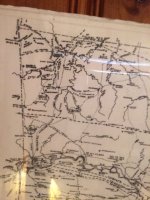
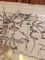
Thanks Mikel. Here's a trail that looks like it got pretty close to your area.

https://www.pinalcentral.com/san_ta...cle_c8d86c08-e852-11e4-aca4-13552c5e487b.html

There might have been a lot of bullion shipped along that trail.


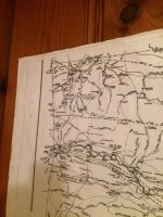
I have copied the map from that link.
I had to make a choice between getting the full trail in the photo, or keeping the credit for creating the map đź—ş.

The credit is much better than getting entire map.

I also took several photos of the trails that existed during the civil war.

I may need to take the map down and set up a tripod to make it easier to expand and read the information easier.

For now, these are about as clear as I can do. I have picked up a respiratory bug, I’m running on impulse power...

I think that there may be a travel-able road that could have been used to get to a railroad for for logging and milling

At one time the southern end of Madison County was a boomtown and was considered to be the best place for the county seat, but failed due to the location being too far away from other County seats.

Anyways here are the map photos.

ImageUploadedByTreasureNet.com1548009081.263946.jpg

ImageUploadedByTreasureNet.com1548009131.858011.jpg

ImageUploadedByTreasureNet.com1548009156.167301.jpg

ImageUploadedByTreasureNet.com1548009186.291930.jpg

If you find the “ wire road “ up north of the rest of the map, I have traveled that road and it was, at that time, an unpaved road and It also ran parallel with the stagecoach road.

The wire road was for a telegraph line.
I’m not sure why they didn’t use the stagecoach road.?.

#/:0{>~

I hope this makes sense to you folks.
This bug and meds combined are about to knock me out.
 

OP
OP
M

mdog

Bronze Member
Mar 22, 2011
2,351
4,406
Thanks for the maps Mikel. Sorry to hear you are feeling bad.

I had a hard time reading the map and I was wondering if the map is of Madison County. If it is, it shows the trails pretty good. I think that you might have your trails that go up to St. Louis and then northeast.

Here is a link that might prove useful.

https://users.stlcc.edu/mfuller/stLouisTrails.html

The second map shows the El Camino Real/Natchitoches Trace going south from St.Louis. This is interesting because it seems to go south all the way to Mexico City and through San Luis Potosi where there are silver and gold producing areas.

El Camino Real

https://en.wikipedia.org/wiki/Natchitoches_Trace

It seems like a good trail to research for possible movements of bullion and ancient trade. This is something I will look at too. If this trail goes north from Mexico City to St. Louis, I know a trail that goes from St. Louis north, along the Mississippi River, up to copper country in Wisconsin. Wisconsin is loaded with ancient copper artifacts.
 

Last edited:

PROSPECTORMIKEL

Silver Member
Mar 31, 2011
2,624
9,424
N/W ARKANSAS
Detector(s) used
FISHER
Primary Interest:
All Treasure Hunting
MDOG the area that I was mostly concentrated on is
Benton, Carroll, Washington, Madison and I think Crawford Counties.

Those are the ones that have Butterfield Stagecoach roads marked, and there were several stage houses in southern Madison County during the boomtown era... not necessarily Butterfield!! Might have been a small off shoot for the boom [emoji95].
There are more than a few Civil War stories about hidden money and I would guess the tales have grown a bit over the years!

I will get some better photos as soon as I can.

I have not even opened the links on this post yet.

#/:0{>~
 

Quinoa

Bronze Member
Nov 25, 2011
1,888
3,273
Purgatory
Detector(s) used
Garrett atx pi 12+20inch coil, Garrett mh series, Garrett 2500+t-hound attchmnt, fisher tw-6 two box, Pulsestar pro ii with various coils up to 98 inches, pulsemaster pro w/1.2 m coil
Primary Interest:
Other
You guys are going to run into alot problems here figuring anything ancient out, when the most outspoken person is pushing 1930'-40's burials and paradolia for all this stuff and pretty much overtook the thread right away which I knew would happen from the start. Good luck guys.
 

releventchair

Gold Member
May 9, 2012
22,413
70,838
Primary Interest:
Other
I wonder if the Native American traders had cache sites, along the trade routes, that they marked with symbols.

Copper culture may provide examples.
I've read of caches. Some more stacked material on surface (vs float copper) alleged to be in relay locations.

Trails leaving the copper range gravitate towards Detroit in my area. Older trails still being followed to get there perhaps....

To the West , rivers were used to head South. Then I'm not familiar with distribution to the S.W. , but Poverty point is acceptable to me as still being related to the copper range so far away from it.
[The site is located in the northeastern corner of Louisiana, northwest of Vicksburg, Mississippi at 33°N (Fig.1). Poverty Point is built on Maçon Ridge, a plateau 90 miles long, and five miles wide, in the swampy floodplains of the Mississippi River. Gibson reports 38 radiocarbon dates, all between 2278 BC (2470-2040) and 650 BC, with most between 1500 and 1300 BC. Gibson says that while the land and waters were biologically rich, the richest asset was the location. “This was one of the few places in the entire Mississippi valley where a departing pirogue could have been paddled without portages]

Where Wisconsin copper culture can be traced is in some of their burial sites. Can they be considered to be along routes of movement?

The thousands of year old sites here are water route related. With few large rivers converging it's not too hard to stay on course. But if markers were needed ,they would seem to be needed at riverine intersections. Or maybe better put ,where streams joined rivers...

There were villages among most of them though. If you knew the nation/tribe had a village at a given location ,you knew where you were. Or could simply inquire. (?)

Where eons old trails/routes were established they had to address rising and receding water levels. At least some are underwater today.
Those needed newer routes could have generated new markers. How permanent or temporary though.....

Most rivers head South. Sun rises in the S.E. here this time of year but basically East.
If you are headed for another waterway by following one you have a decent shot at it.

The Saulk trail cuts across a dry stretch in places but South of big water. With a predominant N.W. wind it might allow smelling that water.

Compacted soil from traffic leaves a good foot trail when used regular. Depending on soil it can take years to "heal" /recover if traffic is stopped. You've seen those.
 

OP
OP
M

mdog

Bronze Member
Mar 22, 2011
2,351
4,406
You guys are going to run into alot problems here figuring anything ancient out, when the most outspoken person is pushing 1930'-40's burials and paradolia for all this stuff and pretty much overtook the thread right away which I knew would happen from the start. Good luck guys.

I wish you would contribute to the thread, Quinoa. You have a lot to offer. It doesn't make any difference if people disagree with each other. Put what you know out there and let our Tnet members decide what is important to them. If somebody wants to debate an issue, it's up to you to decide if you want to take part in that debate.
 

OP
OP
M

mdog

Bronze Member
Mar 22, 2011
2,351
4,406
Ya really mdog he has been sandbagging you that video of Louis Osmer shows they were right there in New Mexico and not once has that sandbagger mentioned anything about it in his some 15 years on this forum and he is right form that area.

I know you're mistaken about that, Cyzak. Those glyphs and information about them have been posted several times on Tnet by the poster you are referring to.

You've been pretty good about sharing information. Keep putting it out there. You might write down a few words that could have a big impact on somebody's research.
 

OP
OP
M

mdog

Bronze Member
Mar 22, 2011
2,351
4,406
For anybody interested, if you have the Travel Channel on cable, a new program of Scott Wolter's America Unearthed is on at 7PM Central time and again at midnight. Tonight he's talking about Lake Superior copper.
 

sdcfia

Silver Member
Sep 28, 2014
3,661
8,894
Primary Interest:
Other
Ya really mdog he has been sandbagging you that video of Louis Osmer shows they were right there in New Mexico and not once has that sandbagger mentioned anything about it in his some 15 years on this forum and he is right form that area.

Unlike the five posters whom I have placed on permanent IGNORE here, I enjoy your posts, cyzak. Those guys can be tighter than a clam with lockjaw at times, but you - I wish you the best of luck with your project this year.
 

OP
OP
M

mdog

Bronze Member
Mar 22, 2011
2,351
4,406
Copper culture may provide examples.
I've read of caches. Some more stacked material on surface (vs float copper) alleged to be in relay locations.

Trails leaving the copper range gravitate towards Detroit in my area. Older trails still being followed to get there perhaps....

To the West , rivers were used to head South. Then I'm not familiar with distribution to the S.W. , but Poverty point is acceptable to me as still being related to the copper range so far away from it.
[The site is located in the northeastern corner of Louisiana, northwest of Vicksburg, Mississippi at 33°N (Fig.1). Poverty Point is built on Maçon Ridge, a plateau 90 miles long, and five miles wide, in the swampy floodplains of the Mississippi River. Gibson reports 38 radiocarbon dates, all between 2278 BC (2470-2040) and 650 BC, with most between 1500 and 1300 BC. Gibson says that while the land and waters were biologically rich, the richest asset was the location. “This was one of the few places in the entire Mississippi valley where a departing pirogue could have been paddled without portages]

Where Wisconsin copper culture can be traced is in some of their burial sites. Can they be considered to be along routes of movement?

The thousands of year old sites here are water route related. With few large rivers converging it's not too hard to stay on course. But if markers were needed ,they would seem to be needed at riverine intersections. Or maybe better put ,where streams joined rivers...

There were villages among most of them though. If you knew the nation/tribe had a village at a given location ,you knew where you were. Or could simply inquire. (?)

Where eons old trails/routes were established they had to address rising and receding water levels. At least some are underwater today.
Those needed newer routes could have generated new markers. How permanent or temporary though.....

Most rivers head South. Sun rises in the S.E. here this time of year but basically East.
If you are headed for another waterway by following one you have a decent shot at it.

The Saulk trail cuts across a dry stretch in places but South of big water. With a predominant N.W. wind it might allow smelling that water.

Compacted soil from traffic leaves a good foot trail when used regular. Depending on soil it can take years to "heal" /recover if traffic is stopped. You've seen those.

That was a great post, RC. I've read that loads of copper culture artifacts have been found along the Rock River in Wisconsin and Illinois. In Wisconsin, there is a Mound Builder settlement called Aztalan real close to the Rock River. The Rock River flows into the Mississippi River at Rock Island, Illinois. I have read about a copper cache site found close to the Mississippi, that seemed to be packed to travel.

Poverty Point is a real interesting place and the mounds are set up in semi-circles, if I remember right. I never heard of the Natchitoches Trace until the other day, but it is really interesting to me. I'm gonna have to give it a closer look.
 

Top Member Reactions

Users who are viewing this thread

Top