Very strange lines in the ground and what I found there...

IMAUDIGGER

Silver Member
Mar 16, 2016
3,400
5,194
Primary Interest:
All Treasure Hunting
So nobody had addressed my suggestion of it being related to land management activities, which seems to be the most likely cause.

How wide are the ā€œpathsā€?
It probably matches the width of a farm implement.

Pretty common to burn/disk/thrash/mow sagebrush to enhance forage.

Iā€™d bet money itā€™s related to habitat enhancement for the Sage Grouse, which has been a HUGE controversy the last 10 years. A pattern like that would provide many breaks between fresh forage and mature cover.
 

Last edited:

Mine Shaft

Hero Member
Apr 11, 2017
929
1,153
Fontana, California
Detector(s) used
NA
Primary Interest:
Prospecting
So nobody had addressed my suggestion of it being related to land management activities, which seems to be the most likely cause.

How wide are the ā€œpathsā€?
It probably matches the width of a farm implement.

Pretty common to burn/disk/thrash/mow sagebrush to enhance forage.

Iā€™d bet money itā€™s related to habitat enhancement for the Sage Grouse, which has been a HUGE controversy the last 10 years. A pattern like that would provide many breaks between fresh forage and mature cover.

I don't think it has to do with habitat enhancement, if it did you would see it in other places. Did you check the DFW to see if that program is on going or in the works ?
 

IMAUDIGGER

Silver Member
Mar 16, 2016
3,400
5,194
Primary Interest:
All Treasure Hunting
I don't think it has to do with habitat enhancement, if it did you would see it in other places. Did you check the DFW to see if that program is on going or in the works ?

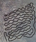
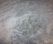
Looking closer, itā€™s clearly habitat enhancement.
In the picture below you can tell the paths were made by a tractor pulling an implement. Even did a half figure eight to make a turn at the upper left...
0AD1CCDF-A31C-4E5E-A8BB-D782F86D5EF3.jpeg

Then there is the fact that it was only disturbed in the thickest parts of the sagebrush patches, evidenced by the enhanced picture below.
8C7B42F0-8B23-4ACF-8997-00CD3E3275AB.jpeg

Itā€™s land management activities. In the old days they would just burn it off. Now they have to take every species (except humans) into consideration.

CASE CLOSED
 

Last edited:

IMAUDIGGER

Silver Member
Mar 16, 2016
3,400
5,194
Primary Interest:
All Treasure Hunting
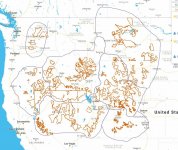
Here are some areas where Sage Grouse habitat protection/enhancements are being considered.
4D6451F7-88FA-4E1A-BB32-DA9BFC6AD8B1.jpeg

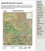
Here are some locations of active Sage brush study areas.
D2074B4D-114F-452D-A416-8B9B9759E357.jpeg

Is your mystery spot located in any of those areas?
 

Tom_in_CA

Gold Member
Mar 23, 2007
13,837
10,360
Salinas, CA
šŸ„‡ Banner finds
2
Detector(s) used
Explorer II, Compass 77b, Tesoro shadow X2
Looking closer, itā€™s clearly habitat enhancement.
In the picture below you can tell the paths were made by a tractor pulling an implement. Even did a half figure eight to make a turn at the upper left...
View attachment 1657518

Then there is the fact that it was only disturbed in the thickest parts of the sagebrush patches, evidenced by the enhanced picture below.
View attachment 1657519

Itā€™s land management activities. In the old days they would just burn it off. Now they have to take every species (except humans) into consideration.

CASE CLOSED

IMAUDIGGER: Your posts are always a good read, and a breath of fresh air. Great sleuthing work.
 

Mine Shaft

Hero Member
Apr 11, 2017
929
1,153
Fontana, California
Detector(s) used
NA
Primary Interest:
Prospecting
Looking closer, itā€™s clearly habitat enhancement.
In the picture below you can tell the paths were made by a tractor pulling an implement. Even did a half figure eight to make a turn at the upper left...
View attachment 1657518

Then there is the fact that it was only disturbed in the thickest parts of the sagebrush patches, evidenced by the enhanced picture below.
View attachment 1657519

Itā€™s land management activities. In the old days they would just burn it off. Now they have to take every species (except humans) into consideration.

CASE CLOSED

As i stated did you check the DFW ? They do not want to destroy the sage brush it is being taken over by evasive weeds/encroachment/and wild fires i don't believe this is a common practice they use to enhance sage grouse habitat. When a mountain covered with sage brush burns weeds over take it and it takes many many years for native plants and sage brush to come back.
 

Last edited:

IMAUDIGGER

Silver Member
Mar 16, 2016
3,400
5,194
Primary Interest:
All Treasure Hunting
As i stated did you check the DFW ? They do not want to destroy the sage brush it is being taken over by evasive weeds/encroachment/and wild fires i don't believe this is a common practice they use to enhance sage grouse habitat. When a mountain covered with sage brush burns weeds over take it and it takes many many years for native plants and sage brush to come back.

I have no clue as to where this area is located. Why would I call DFW?

Yes Cheatgrass and invasive weeds are a concern, however if the sagebrush is allowed to become very dense, wildfires burn with soil sterilizing temperatures, which is much more damaging than discā€™ing, mowing, cabling, ect. Itā€™s possible they sprayed those paths with herbicide or planted native grasses in the disturbed areas. Lots of options that are better than a ā€œstrictly hands off approachā€ I think.

Land management is kind of an evolving science that involves a multitude of different treatment methods.

Controlled low intensity burns are also used.

Here is the USFS current policy on Sagebrush management.

https://www.fs.fed.us/rm/pubs/rmrs_gtr322.pdf

We will never know for sure until the guy that posted this message follows through or discloses the location. Iā€™m ok with that.
 

OP
OP
Goldstar1

Goldstar1

Full Member
May 22, 2010
222
295
Detector(s) used
Goldbug Pro ,
Equinox 800
Primary Interest:
All Treasure Hunting
Ok, I'll retract the "knights templar" locker room talk jab, if you'll retract the "troll" jab, agreed ? :3some:
No Problem Tom, Cheers
 

OP
OP
Goldstar1

Goldstar1

Full Member
May 22, 2010
222
295
Detector(s) used
Goldbug Pro ,
Equinox 800
Primary Interest:
All Treasure Hunting
Hi Goldstar1, what does that area look like today on google maps or earth ? thanks. The photos i posted are not game trails or grazing i think its a die off of a certain plant or something but i cant be sure.
It still looks the same in the sat images .
 

OP
OP
Goldstar1

Goldstar1

Full Member
May 22, 2010
222
295
Detector(s) used
Goldbug Pro ,
Equinox 800
Primary Interest:
All Treasure Hunting
Looking closer, itā€™s clearly habitat enhancement.
In the picture below you can tell the paths were made by a tractor pulling an implement. Even did a half figure eight to make a turn at the upper left...
View attachment 1657518

Then there is the fact that it was only disturbed in the thickest parts of the sagebrush patches, evidenced by the enhanced picture below.
View attachment 1657519

Itā€™s land management activities. In the old days they would just burn it off. Now they have to take every species (except humans) into consideration.

CASE CLOSED

Thanks for enhancing the lines. Your is a good idea its possible but far from case closed. The biggest problem with it is that none of the vegetation/brush is disturbed , no broken branches , no brush piles, no compacted dirt, no tracks , no tilled soil . As i have said when you are actually on the ground there you would never really know the lines are there unless you can see it from a vantage point or the hill like in the last picture.
No it is not in a state mentioned in the STEP study map.
I am open to your idea but I would have to see another matching pattern area as I would think they would have used the same method in other areas. Also at least to me and I dont really know anything about habitat management, it doesn't really look like it would really do anything to help a species that lived in that environment for 1000s of years, and same with fire mitigation it really doesnt seem like it would help at all.

Please post any pictures you can find that would match these patterns for habitat or wildlife management.
 

OP
OP
Goldstar1

Goldstar1

Full Member
May 22, 2010
222
295
Detector(s) used
Goldbug Pro ,
Equinox 800
Primary Interest:
All Treasure Hunting
He does not seem to want to let us know what area he is in or what state he is from....
No I do not. Sorry it is to close to important areas I am working with , nobody goes anywhere near there and I would like to keep it that way. I hope you can understand that.
 

IMAUDIGGER

Silver Member
Mar 16, 2016
3,400
5,194
Primary Interest:
All Treasure Hunting
Burning, mowing, spraying are all methods used to treat invasive weeds. A pattern like that would mitigate erosion problems. The benefit to wildlife is the transition zones created between feed and cover. Old mature sagebrush shuts out native grasses and does not provide the same forage as young sagebrush does. The reduction in sage brush density reduces the fire intensity. I believe that type of environment takes a long time to adjust to disturbances, but Iā€™m no expert.

Why would I spend time calling gov. Agencies or searching the internet for pictures when the OP could pick up the phone and get his desired answers in a definitive way?
 

OP
OP
Goldstar1

Goldstar1

Full Member
May 22, 2010
222
295
Detector(s) used
Goldbug Pro ,
Equinox 800
Primary Interest:
All Treasure Hunting
Does anyone have any ideas on the worm things ? all jokes aside , no I do not think they are actual worms or anything I am just calling them that for lack of a better word to describe them. Its odd that they dont show up in any of the GE sat images until 2004 then they are in all the different sat images until sept. 2011 then in oct. 2011 they are gone but the lines show up and they are not seen again in any future sat images. Maybe totally unrelated but I am open to any ideas.
 

IMAUDIGGER

Silver Member
Mar 16, 2016
3,400
5,194
Primary Interest:
All Treasure Hunting
Are you open to calling the local ranger station (assuming this is USFS administrated land)?
 

OP
OP
Goldstar1

Goldstar1

Full Member
May 22, 2010
222
295
Detector(s) used
Goldbug Pro ,
Equinox 800
Primary Interest:
All Treasure Hunting
Are you open to calling the local ranger station (assuming this is USFS administrated land)?
I dont see why not , but I think it is actually BLM land that borders USFS , there is no signs or anything so its hard to say which it is but i could find out for sure. What would you suggest I ask ? would there be a public record of activities they have done in the area?
 

IMAUDIGGER

Silver Member
Mar 16, 2016
3,400
5,194
Primary Interest:
All Treasure Hunting
Well, if your site visit left you still doubting an easy explanation, Iā€™d learn township, range, section and the administering agency (USGS Topo Quad). Call the local office and talk to the receptionist, explaining you were out hiking and found weird paths in the sage brush and you were wondering if they had done any treatment projects in that area. Ask for an e-mail address for someone that might be able to answer your question.

Send them a screenshot as well as the Google Earth coordinates of this spot.

You will get an answer to your mystery. Be sure to update this thread..I love being right.
 

Top Member Reactions

Users who are viewing this thread

Top