Video 4 - The Peralta Stone Maps with Frank Augustine

Azquester

Bronze Member
Dec 15, 2006
1,736
2,596
Primary Interest:
All Treasure Hunting
Bill,

Following this thread is like following a shotgun blast. However about every 20 posts or so something actually relevant does slip through the radar unnoticed.

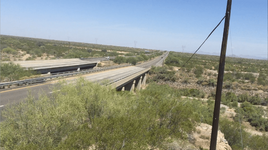
The bridge in the newspaper article and photos is the old Silver King Road Bridge, built in 1916. Today it is called the El Camino Viejo Road Bridge. It spans Queen Creek about 2 and 1/4 miles to the North of the Route 60 Bridge over Queen Creek at Florence Station. This bridge was in the old days on the road from Mesa/Pinal to the Silver King Mine. There are two separate Bridges over Queen Creek in the area.

Each bridge has it's own special history with the Peralta Stone Maps but you have to go back to the beginning to understand both of those histories in their entirety.

Matthew

Matthew, Thanks for the short education. I did notice two other bridges after that one going west. I spent time with google on each one. Only that one has the mountain range in the background and matches the mirrored image.

I don't know the early history of the bridges. But they called this one the Adolf Ruth bridge I suppose for a good reason. And Uncle Matt may be right it may just be the printing process they had back then. But it was in the early 1970's wasn't it?

I tried to see Weavers Needle from there. If you climb the mountain after the bridge you may be able to just see the tip of it.

I spent a few days around the mountain or hills to the west of the bridge looking for that damn cactus with the masons thumb sticking up.
If it was ever there it was probably cut down by Travis or it's a bogus clue.

Another thing that bothers me.

Another word for Barrow or Burrow pit is a Root Cellar. Those were used at a lot of roadside restaurants and gas stations for food preservation back in the days before and after AC.

Funny thing they lined root cellar floors with stone slabs about as thick and big a rectangle as the stone maps! Could he be talking about an excavated collapsed Root Cellar?

Maybe the Stone Maps lined someone's old cellar for a while?

It's a toss up.
 

coazon de oro

Bronze Member
May 7, 2010
1,623
3,858
texas
Primary Interest:
All Treasure Hunting
I found something interesting.

Wayne posted this article yesterday and I've seen it before. It contains a clue too the location of the Stone Map dig.

The McGee article in Frontier Times has had me puzzled for a while. I searched the area but the photo in the article didn't match the terrain. It matched the bridge but not the Terrain.

The back ground mountain range didn't match the road on the other side of the bridge. The road after the bridge goes right in the photo and the real road goes left. It never made any sense when I looked there the article photo didn't match and it had me wondering around where I found the holes Frank and Ryan found.

Well I think I may have just found the answer to it.

Take a look at this:

View attachment 1168199 View attachment 1168190 View attachment 1168191


It seems McGee mirrored the image Horizontally . Now since he went to all that trouble mirroring the image could the directions and locations be mirrored as well?

This may be a clue.

Burrow or Barrow pits are small construction pits used for the purpose of local fill issues while building or construction takes place. Frank and Ryan found the three barrow pits or dig pits associated with Travis's map of where he found them. Or did they?

Was McGee giving us a clue to mirror the instructions to the location where Travis found the maps?

I think I might know the true area where they were found and now it all makes perfect sense!

By the way, the photos are from GE and did solve this issue.

Nice work Bill, but I don't believe McGee went to the trouble of creating a mirrored image. Many photos end up that way when published. Sometimes it is just because the negative is used backwards when enlarging the image.

cwo909, the road is just resurfaced.

Homar
 

Azquester

Bronze Member
Dec 15, 2006
1,736
2,596
Primary Interest:
All Treasure Hunting
Nice work Bill, but I don't believe McGee went to the trouble of creating a mirrored image. Many photos end up that way when published. Sometimes it is just because the negative is used backwards when enlarging the image.

cwo909, the road is just resurfaced.

Homar

Homar,

You guys got me curious so I found the whole article the picture came from. All other photo's in the True West Magazine article are correct and not mirrored. So since it was a magazine and not a newspaper with other photo's in it not reversed it has some relevance. I believe it was mirrored on purpose for a reason in the article. Marlowe was mirroring it on purpose that old dog!
 

Old

Hero Member
Feb 25, 2015
656
1,409
Virginia
Detector(s) used
Whites
Primary Interest:
All Treasure Hunting
Bill,

This time I tend to agree with you. Good work! And Matthew you are right also. We are looking at two different bridges.

Bill, forgive me but I took the liberty to combine the McGee picture and the old Route 60 bridge (Now El Camino Viejo Road Bridge) and I removed newer structures by touching up the current GE street view just to keep them from being distractions. No doubt in my mine the McGee photo is taken from the El Camino Viejo Rd location and it has been flipped. The mountain range lines up and even the telephone poles are correctly located. Its the same view.

Now; that begs the question to Ryan and Frank. Did you find the dig holes off current route 60 south of El Camino Viejo, or off El Camino Viejo and north of it?

combined old bridge & McGee photo.jpg PSM sites 1 & 2.jpg
 

roadrunner

Bronze Member
Jan 28, 2012
1,230
520
Pinal Mountains,Arizona
Detector(s) used
Garrett Groundhog-2012-1st MD.
White's Goldmaster V/Sat-2nd-MD-2013
Tesoro Lobo-2015-3rd
Primary Interest:
Prospecting
Thats the article I was talking about.
Also,the highway was not moved,only the curves where straightened out in those years.
The new highway around florence Junction was done in the last Twenty to Thirty.
Here is a source with link.

Quiote:
Between 1949 and 1952, a number of sections of U.S. 60 between Superior and Globe were realigned and cleaned up to reduce the number of curves and make the road safer.

Arizona @ AARoads - U.S. Highway 60
Can you post a link to the original newspaper article ?

All I have is this....... from the 1973 Frontier Times McGee article....same photo

FRONTIER TIMES - 1973 - PERALTA STONE MAPS ARTICLE - DesertUSA.com/mb3

View attachment 1168029

Thanks:SH.

.
 

Last edited:

Old

Hero Member
Feb 25, 2015
656
1,409
Virginia
Detector(s) used
Whites
Primary Interest:
All Treasure Hunting
The road project analysis that CW provided links does affect this area and talks quite a bit about it. Appears new construction/improvement stops just short of the bridge approach. Unless I am very mistaken (its possible) the 2004 project covered the territory from mile marker 211 all the way back to Superior. I believe the El Camino Road exit is at mile marker 212. Granted; the location of the right of way was not changed (significantly) in THIS area in the 2004 project.

Also of some interest is the lack of any historical/archeological report information indicating the Peralta Stone Map find site. If, as they are, on display in the local museum seems their discovery site should have been included in the historical significance portion of the report. Gives more credence to the El Camino Viejo Road site???? Maybe?
 

Azquester

Bronze Member
Dec 15, 2006
1,736
2,596
Primary Interest:
All Treasure Hunting
I had too take a look again at where they were. It's right off the side of the new bridge east side I thought it was there. That's the site I was at in the beginning searching for the birth place of the stone maps so it must have been that map they have that got me there. I have photo's of the same holes but couldn't find them!

I read a new take of the Burrow Pit. In one account it was called a Burro Pit or a Pit a Burro falls into but can't get out of! Grave of a Donkey.

Travis's first partner his uncle I believe found other parts of a Pack animal like a burro. A pack saddle with gear a ruby jeweled watch and a large gold jeweled cross. This got between his uncle and the treasure hunts. Travis spent thousands of his own money searching for what the maps lead to. Why would someone spend all that money on maps they made themselves?

One story puts the location of the maps by the east end of the north lane of the new bridge and explains the maps were found during the construction of the new bridge which makes no sense!

But arrow head hunters know Indians camped along streams or close to water supplies on flat sandy areas which is where I've found Pottery and arrow heads myself.

Near a high hill so they have a look out scouting for game and European intruders.

Any old cattle pond's or drainage ditches could be the old site of Indian camps any of them as most were here when we came along in this land of desert. The Drainage Ditches at one time were trails that eroded from them over time. Clay or flint in the area is a good indicator of Indian activity in the area. I'm going there again to hunt only arrow heads and see where it leads me!
 

roadrunner

Bronze Member
Jan 28, 2012
1,230
520
Pinal Mountains,Arizona
Detector(s) used
Garrett Groundhog-2012-1st MD.
White's Goldmaster V/Sat-2nd-MD-2013
Tesoro Lobo-2015-3rd
Primary Interest:
Prospecting
1966 topo.
Queen Creek tank.
1/2 mile NE of Stone spot.
Right next to El Camino Vejo.
You can see it from GE.Has water quite a bit through the year.
Also look behind the gas station at Florence Junction,another large tank there.
A lot of times when monsoons hit,this tank over flows and creates a small creek which flows out through the fence and dirt embankment and closes down the north side of the road.
Bet its been there a while. Maybe.
Will see if I have an older topo.
 

Last edited:

somehiker

Silver Member
May 1, 2007
4,365
6,426
Primary Interest:
All Treasure Hunting
Let us back up a bit for another look, since Ryan provided both a map and a GE overview of the area where he and Frank shot the video.

Hi Captain - nice to hear from you!

Compare the Tumlinson Map and the Google Earth Map along with the drop pin of where Frank and I parked to verify. Frank and I parked exactly where Tumlinson did on his map - and not "too far" away from the car, we found what you saw in the video. It was all pretty fun / exciting!


Tumlinson Map:

View attachment 1166239


Current Google Earth Map

View attachment 1166240


The map image is from Mike M's website, and according to the note below the map, originated in Dr. Glover's book "The Lost Dutchman Mine of Jacob Waltz"

View attachment Glover's map of Discovery Site.bmp

Someone who has a copy of Glover's book might be able to confirm that both the image and the attribution above the map did indeed appear in that book .
Although Matthew has told us the map was cropped from a water resources map dated 1969, that map in itself appears to have been copied from a much earlier map, made long before any of improvements to the highways and interchange were done .

This road map, copied and cropped from one of the links CW provided, clearly shows the highway alignments as they existed back in 1939.
I have circled the area under discussion, which includes El Camino Viejo ( part of the original road between Apache Junction and Florence Junction), US 60 as it existed in 1939, as well as US 79 to Florence, which is also classed on the roadmap as a highway.

View attachment 1938 map.bmp

It seems that many of the disagreements surrounding where the stones were actually found originate in conflicting perceptions of what was meant when the term "old highway" or "old US 60" was used by those who passed their own information on down the line.

Another map from Gary's web site :

http://freepages.genealogy.rootsweb...eralta/peck/Peck-Brower - January 5, 1965.pdf

Here is a photo I shot awhile back.... taken from a point on the south bank of QC, and showing both newer and older bridges.....

100_1536 QC.png

And here is aerial view from 1966...

View attachment QC 1966.bmp
 

Last edited:

somehiker

Silver Member
May 1, 2007
4,365
6,426
Primary Interest:
All Treasure Hunting
1966 topo.
Queen Creek tank.
1/2 mile NE of Stone spot.
Right next to El Camino Vejo.
You can see it from GE.Has water quite a bit through the year.
Also look behind the gas station at Florence Junction,another large tank there.
A lot of times when monsoons hit,this tank over flows and creates a small creek which flows out through the fence and dirt embankment and closes down the north side of the road.
Bet its been there a while. Maybe.
Will see if I have an older topo.

Could you scan and post the relevant part of that Topo Matt ?
Thanks in advance.....SH.

The USGS topos are sometimes revised and used by the military.
There might be one from the 1940-50 time frame available somewhere as well.
 

cw0909

Silver Member
Dec 24, 2006
4,364
3,222
Primary Interest:
Other
thanks somehiker for the correction, i think i get it now, the area Frank and Ryan
are talking about for where the stones were found, is west of jct 79 and 60 ?

i like your imgs, but for some reason, they wont open, i can only download them
to view them, any ideas on how to fix that, i can open all other posters img without
downloading them to view
 

coazon de oro

Bronze Member
May 7, 2010
1,623
3,858
texas
Primary Interest:
All Treasure Hunting
Let us back up a bit for another look, since Ryan provided both a map and a GE overview of the area where he and Frank shot the video.


The map image is from Mike M's website, and according to the note below the map, originated in Dr. Glover's book "The Lost Dutchman Mine of Jacob Waltz"

View attachment 1168388

Someone who has a copy of Glover's book might be able to confirm that both the image and the attribution above the map did indeed appear in that book .
Although Matthew has told us the map was cropped from a water resources map dated 1969, that map in itself appears to have been copied from a much earlier map, made long before any of improvements to the highways and interchange were done .

This road map, copied and cropped from one of the links CW provided, clearly shows the highway alignments as they existed back in 1939.
I have circled the area under discussion, which includes El Camino Viejo ( part of the original road between Apache Junction and Florence Junction), US 60 as it existed in 1939, as well as US 79 to Florence, which is also classed on the roadmap as a highway.

View attachment 1168393

It seems that many of the disagreements surrounding where the stones were actually found originate in conflicting perceptions of what was meant when the term "old highway" or "old US 60" was used by those who passed their own information on down the line.

Another map from Gary's web site :

http://freepages.genealogy.rootsweb...eralta/peck/Peck-Brower - January 5, 1965.pdf

Here is a photo I shot awhile back.... taken from a point on the south bank of QC, and showing both newer and older bridges.....

View attachment 1168401

And here is aerial view from 1966...

View attachment 1168402

Howdy Wayne,

So the Old 60 they refer to, and the New 60 are one and the same. They only constructed a new bridge south of the old bridge to make it a freeway.

Homar
 

Old

Hero Member
Feb 25, 2015
656
1,409
Virginia
Detector(s) used
Whites
Primary Interest:
All Treasure Hunting
I'm giving myself a head ache, LOL

Let me take a different approach to this. Hope this makes sense. Then I'll shut up and just listen


The pictures Wayne has posted as well as the map shot Ryan used show a 2 span bridge with a total of 4 lanes, 2 lanes east bound and 2 lanes west bound. I believe that is "new" Route 60.

The McGee photo and article is a single span bridge with one lane each way. I believe that is El Camino Viejo Rd.

Both roads are in use currently. Of course, Rt. 60 has the heavier traffic.

Make sense?
 

markmar

Silver Member
Oct 17, 2012
4,119
6,260
Primary Interest:
All Treasure Hunting
I'm giving myself a head ache, LOL

Let me take a different approach to this. Hope this makes sense. Then I'll shut up and just listen


The pictures Wayne has posted as well as the map shot Ryan used show a 2 span bridge with a total of 4 lanes, 2 lanes east bound and 2 lanes west bound. I believe that is "new" Route 60.

The McGee photo and article is a single span bridge with one lane each way. I believe that is El Camino Viejo Rd.

Both roads are in use currently. Of course, Rt. 60 has the heavier traffic.

Make sense?

No , but is interesting . Looks like somebody is trying to put his two legs into one shoe . At this point I only shut up and listen .
 

somehiker

Silver Member
May 1, 2007
4,365
6,426
Primary Interest:
All Treasure Hunting
Could be your computer/browser settings CW.

Yes, Old. The Tumlinsons were not from the area and wouldn't have known that the section of two lane, which is now called "El Camino Viejo", was part of the original/old road between Apache Junction and Florence Junction. When they told others about where and how they found the stones beside Hwy 60 at Queen Creek, and the story was passed around, someone local may have added "old" to the description . It may have been just an assumption on their part, or it may have been deliberate since many believe the trail begins where the stones were found. I have more in my files, which I will share later.

Regards:SH.
 

Garry

Sr. Member
Apr 19, 2009
256
496
I hope I’m not muddying the water further but this is how I arrived at my take on the question of the road configuration most likely used by Travis Tumlinson while traveling Highway 60 in the area of present day Florence Junction.

Somehiker has already done the heavy lifting and the map he posted (From cw0909’s post) clearly shows the configuration of the state highway in 1939 as being straightened and bypassing the old bridge.

I am posting two earlier maps, identified as Pinal County maps, which contain a bit more detail than the 1939 Arizona State map.

Map of Pinal County Arizona [1927]

Pinal County: Map of Pinal County Arizona [1927] :: Historic Arizona County Road Maps

This cropped map is only that portion around Florence Junction. Hopefully you can follow the State Highway which I didn’t see identified as Route 60 and identify the Florence Junction intersection which is also not identified. You can pick up Queen Creek and the “old” bridge where the State Highway crosses Queen Creek.

The point being that in 1927 there was only the one Queen Creek crossing and the state road had not been straightened.

Highway 60, Pinal County Map 1927.jpg

Map of Pinal County Arizona [1937]

Pinal County Arizona: General Highway and Transportation Map. 1937. Sheet 1 of 7. Prepared by the Arizona State Highway Department in cooperation with the U.S. Department of Agriculture, Bureau of Public Roads. Data obtained from State-wide Highway Planning Survey

Pinal County Arizona: General Highway and Transportation Map. 1937. Sheet 1 of 7. Prepared by the Arizona State Highway Department in cooperation with the U.S. Department of Agriculture, Bureau of Public Roads. Data obtained from State-wide Highway P

Highway 60, Pinal County Map 1937.jpg

This map clearly shows that, by at least 1937, Route 60 had been straightened west of Florence Junction. Both bridges, the old and new, are also clearly shown.

If Travis Tuminson were only passing through Arizona, in the 1948 time frame, He would have almost surely traveled the straightened version of Highway 60.

There was a bridge, by as early as 1937, crossing Queen Creek in very close proximity to the modern day crossing.

Ryan and Frank were parked at the most likely Queen Creek Crossing used by Travis Tumlinson.

Nothing to do with anything but only as a point of interest, our “old” bridge (along with several other bridges) was placed on the National Historic Register, September 30, 1988. Below is an overview of the history of our old bridge.

In 1917, the Arizona Highway Department began the engineering for the Mesa-Superior Highway in Final County. As one of the first Federal Aid Projects in the state/one 11.71-mile segment of the route near Florence Junction was designated FA7, Section 2-B. State work forces began work on the grading and small drainage structures of the section in March 1919. The crossings of the Queen Creek main and overflow channels north of Florence Junction, however, required more substantial structures, and for these the AMD bridge department delineated twin long-span Luten arches like the recently completed Holbrook Bridge. (The overflow channel bridge was later eliminated by raising the highway grade slightly.) AHD contracted with the Topeka Bridge and Iron Company of Kansas to build the bridge over the main channel: AHD to provide cement and steel for $4016, Topeka to design and build the bridge for $14,000. Under the direction of AHD Inspector James Bone, Topeka completed the Queen Creek Bridge on May 6, 1920. The highway (U.S. 60) has since been realigned, and the bridge now carries local traffic in essentially unaltered condition. Strategically located on the routes between Phoenix and Tucson and Phoenix and Globe, the Mesa-Superior Highway formed a short but pivotal route in central Arizona, and the Queen Creek Bridge provided an important crossing on that route. As such, this structure enjoys some degree of historical significance as an integral link on a regionally important transportation artery. Technologically, the bridge is significant as an exemplary long-span Luten vehicular arch. It is one of thirteen Luten arches identified in Arizona, all of which were associated directly - either through engineering or construction - with the Topeka Bridge and Iron Company, the western representative of Daniel B. Luten's Indiana-based National Bridge Company. Designed by Topeka Bridge staff engineer R.V. Leeson and built by the company Itself, Queen Creek Bridge is thus closely associated with this important national bridge company. It was the last Luten arch built on a state route. In unaltered and good condition, the bridge typifies an important Arizona bridge building trend.

I look forward to Ryan posting modern day photos of the old bridge site. I want to see the structure underneath that’s holding the bridge up!

I personally believe the question of the area of the alleged Tumlinson discovery site has been answered, certainly to my satisfaction. It's still a long ways from this general statement to the actual place where Travis claimed to have stumbled over a corner of the Horse/Witch stone.

Old posted a very interesting photo from 1955 of a newer bridge and I think we may be able to get closer to recreating the configuration that would have been seen by Travis in the 1948-49 time frame.

Garry
 

Hal Croves

Silver Member
Sep 25, 2010
2,659
2,695
Hal old buddy, you wrote "Is that how the number thirty five would have been written in 1535?"

So you were not actually asking what style of numerical writing or font would have used in to write the number thirty five back in the year 1535? What then were you asking if not that.

That is exactly the question I was asking. Numbers written on paper/parchment and numbers carved into a rock face may not have been used the same way. I was hoping that markmar (or you since you seem interested) could provide an example of a 1535 engraving. A headstone, a plaque, a coin (actually, a Spanish coin dated 1535 is easy), or a sculpture.

The information is out there.
 

Last edited:
OP
OP
RG1976

RG1976

Sr. Member
Mar 30, 2015
336
440
Scottsdale, Arizona
Detector(s) used
Tesoro Lobo SuperTraq & Vaquero

Leupold BX-3 Mojave & RX1200i Rangefinder
Primary Interest:
Other
Morning everyone!

Loving this conversation - thank you for being a part of the thread!

Garry - "Ryan and Frank were parked at the most likely Queen Creek Crossing used by Travis Tumlinson."

Take a look at this shot - its a screen grab from some footage that I took for Video 4 - that I didn't include in the YouTube version.

Now - to preface - its entirely possible this is just a play of light - but it looks to me like one of the bridges has 4 "support beams" and the other bridge has 2. Its possible that the bridges were built by a different crew - perhaps at different times. I won't know until I go back. Also - look closely at the construction style of the "guard rails" on each bridge. One has a built in "railing" system and the other does not. I am probably calling these things completely wrong - but I think you all will know what I am trying to say

But you folks have brought up great dialogue about the bridge(s) so I will, as part of video 5, spend time walking down to the bridges - getting better footage of them - from underneath and all around. Perhaps there are dates on the bridges?
 

Attachments

  • Screen Shot 2015-05-30 at 5.10.35 AM.png
    Screen Shot 2015-05-30 at 5.10.35 AM.png
    1.4 MB · Views: 140
Last edited:

Top Member Reactions

Users who are viewing this thread

Latest Discussions

Top