Kiros32
Bronze Member
- Feb 21, 2006
- 1,407
- 441
- Detector(s) used
- XP Deus, Whites MXT
- Primary Interest:
- All Treasure Hunting
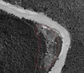
The thick white line is a river. The objects appear to be in a clearing along the river. Any idea what they are?
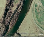
kuhnfucius said:That looks like a portion of the river along the horn. If it is, what did I say! Bingo! Burns me up after "Edde" said of my post "Do not believe a word you read on here, for the most part, use your best judgment, while you still have it. The longer you read this, the less good judgment you will possess."
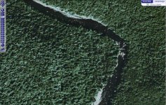
kuhnfucius said:I have reviewed down stream bends similar to the spot in question, comparing the erosion and deposition patterns. The place of attention is right at the spot that usually gets a lot of deposits from flooding. Due to the steepness of the walls of the canyon here I tend to discount the idea the river has changed course as other reply has suggested. The immediate angle of the walls might also limit deposits seen in other inside bends, which usually gives them a clean or wiped out appearance. Note that in the newer pictures this area is tree covered. The inference being that _if_ the clearing seen in the older photos was cause by water, why is it now tree covered? Another mystery to me involves why put even a temporary structure in this location? If they are buildings, I have some thoughts on why. First some more info is needed. In the original photos (another thread) there appeared to be a railroad bride and tunnel across the (SW end?) neck of this bend / loop (not shown here). This testifies to the steepness of the terrain, as the older roads usually follow the river. If this is a railroad bridge and tunnel, do you know when it was constructed relative the date of the 1939 photo? If the 1939 photo is covers a larger area, is this bridge and tunnel present? thanks K.
chong2 said:if they bothered to take a photo in 1939 then there was something they were trying to photograph, no?
 Since I have never posted a pic here I am going to use this as practice. It is coming into Montoursville Airport. Well that seem easy enough, hope it comes over.