What to look for in google earth?

vtgoldprospector

Jr. Member
Jun 27, 2012
74
7
Eastern Long Island
Detector(s) used
Google Earth, my hands and a pan!
Primary Interest:
Prospecting
Oh yes! The question is what are you looking for.. It is like relic hunting in itself that you don't know what you will find until you look and find something. I found a small airplane mid-flight and something I built and shipped out of state that I found in street view. But I typically use it to look at rivers.
 

generic username

Full Member
Jul 7, 2008
180
53
Mid Michigan
Detector(s) used
ctx3030, Garrett Pro Pointer
Primary Interest:
Other
i use google earth's historical images option along with historicaerials.com combined with plat maps from the 1800's of my locality on memoriallibrary.com, all 3 i can get a pretty good idea on where foot traffic was from old no longer existent barns/houses/driveways along with where homes used to be way before my time... then you know where and or who to ask for permission to hunt.
 

OP
OP
B

blackrose

Full Member
Oct 12, 2012
114
73
Detector(s) used
tesoro compadre
Donovan.flannery said:
i use google earth's historical images option along with historicaerials.com combined with plat maps from the 1800's of my locality on memoriallibrary.com, all 3 i can get a pretty good idea on where foot traffic was from old no longer existent barns/houses/driveways along with where homes used to be way before my time... then you know where and or who to ask for permission to hunt.


That's cool! So here's what I'm wondering, all these old foot traffic spots in my area are likely to be on paved roads or private property these days, so how would you then proceed?
 

generic username

Full Member
Jul 7, 2008
180
53
Mid Michigan
Detector(s) used
ctx3030, Garrett Pro Pointer
Primary Interest:
Other
private property you just work up the confidence to walk up and door knock, paved roads wait till a road tear up.


but by foot traffic im not talking roads.. im talking from barn to house or a park that had a fence with a gate that funneled people, old fairgrounds..
 

vtgoldprospector

Jr. Member
Jun 27, 2012
74
7
Eastern Long Island
Detector(s) used
Google Earth, my hands and a pan!
Primary Interest:
Prospecting
If I'm not mistaken and I don't know if it applies to all maps but as a general rule with some of my printed maps is, if they are on the map they are public. I find that the roads are not an issue, it's the path between the road and the river that needs to be looked into.
 

generic username

Full Member
Jul 7, 2008
180
53
Mid Michigan
Detector(s) used
ctx3030, Garrett Pro Pointer
Primary Interest:
Other
If I'm not mistaken and I don't know if it applies to all maps but as a general rule with some of my printed maps is, if they are on the map they are public. I find that the roads are not an issue, it's the path between the road and the river that needs to be looked into.


lolwut? if theres a place of interest shown on a map from say the 1800-1900's but is now on current private property.. its not open to anyone without permission of the property owner to be on said property.

if your saying if its on a map and its public.. well yes, its public knowledge.


parks are a different matter. here in Michigan, the state parks are for the most part closed to detectorist except a select few (like 3 or 4) which are fully open... but for the most part your only allowed to detect in the parkinglot and very few beaches iirc there.
my citys park is questionable because removal of sod/earth plants and such could be technically determined based on the officers opinion of what your doing.. ie digging a small plug carefully
and as for the neighboring county, the township parks there are primarily old farmland and fair game as there are no rules against detecting whatsoever.

Im not trying to create a argument... but always ask permission to hunt prior to walking out on privately owned property. check your parks rules/ordinances and always keep your digs clean and neat.. ie dont leave open holes and dirt everywhere + pick up any and all trash ;)
HH
 

vtgoldprospector

Jr. Member
Jun 27, 2012
74
7
Eastern Long Island
Detector(s) used
Google Earth, my hands and a pan!
Primary Interest:
Prospecting
lolwut? if theres a place of interest shown on a map from say the 1800-1900's but is now on current private property.. its not open to anyone without permission of the property owner to be on said property.

if your saying if its on a map and its public.. well yes, its public knowledge.


parks are a different matter. here in Michigan, the state parks are for the most part closed to detectorist except a select few (like 3 or 4) which are fully open... but for the most part your only allowed to detect in the parkinglot and very few beaches iirc there.
my citys park is questionable because removal of sod/earth plants and such could be technically determined based on the officers opinion of what your doing.. ie digging a small plug carefully
and as for the neighboring county, the township parks there are primarily old farmland and fair game as there are no rules against detecting whatsoever.

Im not trying to create a argument... but always ask permission to hunt prior to walking out on privately owned property. check your parks rules/ordinances and always keep your digs clean and neat.. ie dont leave open holes and dirt everywhere + pick up any and all trash ;)
HH


I was referring to current street maps. I do apologize for the lack of clarity.
 

Calvin.Coin

Sr. Member
Sep 27, 2012
289
78
Southwestern America
Detector(s) used
Garrett Ace 250
Primary Interest:
All Treasure Hunting
Using Google Maps...I found a carnival that I never knew existed and was able to determine locations of concession stands, the Ferris wheel and rides, plus other things such as where the queues started. Also was able to note where the parking area was. Haven't had a chance to search yet but have high hopes...

treasure is where you find it,
cc
 

vtgoldprospector

Jr. Member
Jun 27, 2012
74
7
Eastern Long Island
Detector(s) used
Google Earth, my hands and a pan!
Primary Interest:
Prospecting
The library is open for the week!

I want to share this with everyone here...

A limited time access to a Google Earth library for gold prospecting in Vermont. It is designed to combine layers of imagery so you can understand an area and see records of gold or other ores nearby. I am currently building the drainage basin segments overlay and have more to add. These are great for knowing what type of river to expect due to the segments size and slope. At a glance I can see Vermont is getting serious rain statewide. Lots of blue dots.

This is the kml that contains the library. (see the first 40 seconds of video below on how to import it)
http://www.goldmapmaker.com/?file=gmm

All content is streamed as requested and Google Earth must be installed.

Here is a run though to give you an idea of how to use it.


Gold Map Maker -- The ultimate prospecting tool!

fyi, This is my personal library that I use to prospect with and I decided to make it available for others. I would appreciate input from any of you on how to make it better. Thanks!
 

Last edited:

kam50

Sr. Member
Mar 7, 2009
252
83
Canton,Ohio
Detector(s) used
Fisher F2 Garrett Pro pointer
Minelab X-Terra 305 Garrett pro pointer(Fake one got ripped off!)
Primary Interest:
Metal Detecting
google maps

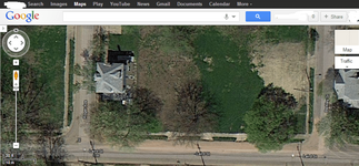
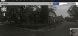
Hello everybody. Just read the replies and wanted to add my 2 cents about google maps. I have been using google maps for about 2 weeks now to locate lots and places to detect. Was riding my bike through a older neighborhood and noticed all the lots and boarded up houses. Detected one corner lot, just hit the curb strip that day, found alot of clad pennies. Went home and checked out the area on maps and did a overhead view. Showed the area I was at. Then I zoomed in and next thing I saw was houses. Thought I moved my location, zoomed out and there was the lot I detected, minus the houses. So when I go street level view, I can see where all the houses were, on this lot there were 6 houses that were torn down. But what I think is cool is i can now tell where the houses are and the front and back yard. Well just wanted to share. HH
 

Attachments

  • laird st.png
    laird st.png
    296.2 KB · Views: 178
  • laried st.png
    laried st.png
    134.9 KB · Views: 107
Last edited:

vtgoldprospector

Jr. Member
Jun 27, 2012
74
7
Eastern Long Island
Detector(s) used
Google Earth, my hands and a pan!
Primary Interest:
Prospecting
It may be of interest to you that you can go back through the past imagery. Some of the images go back to the 90s allowing one to see what was. Granted the clarity is nowhere near what they have today... but may still get the job done.

I don't think I could do a fraction of what I do now without GE. Not easily anyway!

Gold Map Maker -- The ultimate prospecting tool!
 

Top Member Reactions

Users who are viewing this thread

Top