X Prospect on a topo map

PatrickD

Hero Member
Jul 23, 2012
845
700
Colorado
Detector(s) used
Garrett AT Pro
Primary Interest:
All Treasure Hunting
Hi Everyone,

I have been using some topo software to map out areas I want to research.

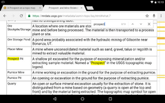
On the topo is a common mark. It is either an X or two crossed picks. It has the word Prospect next to it.

Now, I understand what prospecting is but I am curious what had to happen for this prospecting site to have ended up on a topo map. Does it mean a claim was filed? Is there a hole in the ground at the location?

Here is a screen shot showing what I am referencing.

topo map with Prospect.jpg

Any ideas or thoughts?

Patrick
 

Upvote 0

goldog

Hero Member
Sep 25, 2012
923
987
Tujunga, CA
Detector(s) used
Bazooka Gold Trap, A-51, Gold Pan
Primary Interest:
Prospecting
Go look. Old maps had a lot of marks. That looks like it is a small gully near some peaks. First find the jeep trail. Then search out the "prospect ".
 

Last edited:

galenrog

Bronze Member
Feb 19, 2006
2,019
2,209
A "prospect" could be anything from a small surface scraping to a shallow shaft, pit, or tunnel. Nearly everything more extensive would normally be labeled as a mine.
 

OP
OP
PatrickD

PatrickD

Hero Member
Jul 23, 2012
845
700
Colorado
Detector(s) used
Garrett AT Pro
Primary Interest:
All Treasure Hunting
I did the search and even exchanged some email with the folks at the USGS. My question isn't what is prospecting. Its more about how it ended up on the map. I mean, I know what prospecting is.

That one in the picture is right down the road from me. I was in there scouting out the area but did not see any evidence of mining. It more looks like a dry river bed. I will go back over there this weekend and look closer. (I did not see the marking on the map until after I came home and was researching the area where I was driving on the jeep trail. Its adjacent to BLM land.

When I look at the topo map software, the X Prospect is everywhere in the mountains and such. It is a common mark. The legends just say Prospect or something as nondescript.

This is national geographic software for topo maps by state. It allows me to put any amount of notes, pictures, research information, etc., at a location like a thumbtack. It can find a place by GPS coordinates. Its a cool tool.

I just can't figure out how the X Prospect location came to be identified and registered with National Geographic to appear in a specific location on their TOPO maps. I was in the area where that map was representing. There were no claim markers of any kind.

It just makes me wonder if those are good targets to go prospect.

You guys have a ton of experience and can tell me if it is a waste of time. I might be barking up the wrong tree, but its still a tree.

Any thoughts on the matter?

Patrick
 

Last edited:

goldog

Hero Member
Sep 25, 2012
923
987
Tujunga, CA
Detector(s) used
Bazooka Gold Trap, A-51, Gold Pan
Primary Interest:
Prospecting
These are from old USGS maps I would guess. Any sign of the old jeep road?
 

chlsbrns

Bronze Member
Mar 30, 2013
1,636
656
Detector(s) used
Excalibur II
Primary Interest:
Other
A shallow pit excavated for the purpose of exposing mineralization and/or extracting sample material. Named a “Prospect” in the USGS topographic map legend.

It could be any mineral.
 

OP
OP
PatrickD

PatrickD

Hero Member
Jul 23, 2012
845
700
Colorado
Detector(s) used
Garrett AT Pro
Primary Interest:
All Treasure Hunting
Thanks for the help. It is much appreciated.

Still can't get my mind around how some prospectors efforts ended up on a topo map. It had to be registered in some way. Is it possible that there was some sort of prospecting claim that wasn't a full fledged claim? Or is it possible the map makers actually found each one of these?

I guess I am trying to find out how to get the list if it exists.

P.
 

Goldwasher

Gold Member
May 26, 2009
6,077
13,225
Sailor Flat, Ca.
🥇 Banner finds
1
Detector(s) used
SDC2300, Gold Bug 2 Burlap, fish oil, .35 gallons of water per minute.
Primary Interest:
All Treasure Hunting
Thanks for the help. It is much appreciated.

Still can't get my mind around how some prospectors efforts ended up on a topo map. It had to be registered in some way. Is it possible that there was some sort of prospecting claim that wasn't a full fledged claim? Or is it possible the map makers actually found each one of these?

I guess I am trying to find out how to get the list if it exists.

P.
a surveyor on the ground
 

winners58

Bronze Member
Apr 4, 2013
1,729
4,058
Oregon
Primary Interest:
All Treasure Hunting
a prospect is when someone found an outcropping or ledge and had a state geologist do an investigative opinion
in the case of a prospect it would have been a positive report but needed more work to prove its worth.
then reported to USGS then the TOPO maps that come in the 7.5 minute quadrangle or like the 1:250,000 scale come from them
to find out more about a prospect would need some detective work in the state geology dept. or USGS
such as historical mining records or sometimes look for the reports that go with the 7.5 minute topo maps.

to get map plates and a report like this; http://pubs.usgs.gov/of/1966/0087/report.pdf

go here; USGS National Geologic Map Catalog Search select your state
go to your area do a search once you get to the plate page look for a report and documents might have to click "availability"
the legend/index will give the historic name, then you can look for that in the report

example search;
Open-File Report 66-87 - Idaho springs, Colorado https://pubs.er.usgs.gov/publication/ofr6687
(some are older PDF's and need to save or open outside of the browser)

if you get too many hits try a google search with USGS mineral resources Colorado Open-File Report

you can also get to the quadrangle maps and reports here; http://mylandmatters.org/Maps/Geology.html
draw a small square with the mouse around your area to zoom in, then select the "i" on the right navigation section
then click on the map to bring up "results" then click "link to more geologic maps" will bring you to the USGS maps & reports
when you select a report and open the description page select "availability" most should be available online
 

Last edited:

63bkpkr

Silver Member
Aug 9, 2007
4,069
4,618
Southern California
Detector(s) used
XLT, GMT, 6000D Coinmaster
Primary Interest:
All Treasure Hunting
Hi PatrickD, at one time there was a spot on the ground where some person found something of interest, like a mineral, maybe they broke up some rock to confirm the existence of a vein or they actually formed a pocket of a foot in depth with the entire spot covering 2 to 9 sq. ft, each prospect could have a distinctly unique look and shape. How did that spot get on a map, I'd go with Goldwasher and Winners 58 comments. It is possible that a surveyor accidentally came across 'the site' though in the places I've found these surface disturbances I'd think that the person who made the disturbance told a government agent about it in a request for examination for possible filing status.

These surface disturbances could have been made by lone prospectors though I'd Guess a corporation hired someone to scout out an area in a known deposit zone and then had it inspected by a government agent after some test indicated it might be worth them filing a claim on the property. That last sentence has a great deal of guess-timates in it though I've offered it as some of those surface disturbances are heck and gone from any existing trail but then Ma Nature tends to cover over Mans trivial chicken scratching's over time. I've come across one of these disturbances in a very rugged mountain/forest terrain and it was on the map as an X, it was also in a zone where gold was prevalent. A prospecting metal detector may give you a bit more knowledge about the spot and then again it might not. Best of luck with your searching!.............63bkpkr
 

OP
OP
PatrickD

PatrickD

Hero Member
Jul 23, 2012
845
700
Colorado
Detector(s) used
Garrett AT Pro
Primary Interest:
All Treasure Hunting
Thanks everyone, you are really appreciated for the input.

There are a lot of dry 'gulches' around here. Not sure if that is the best term but it is in use here. (I just move here from Texas and it would have been called an orroyo, dry wash, gully, etc.) The have evidence of extreme amounts of water rushing through them but it is probably seasonal with the spring snow melt.

There is one behind my property that has a layer of black sand in it about 4 inches down. Nothing to brag about as far as finding gold in it. Lots of large grain magnetite and hematite as large as a pencil eraser in some cases. It drains into that gulch on the map picture.

Its funny, I have been treasure hunting for many years, mostly cache hunting and metal detecting. Gold prospecting is new to me but I am thoroughly enjoying it. I guess the general consensus is that the prospecting areas marked on the map did not pan out (pun intended) for the prospector so it isn't really worth working?

I have been spot checking the same types of places you would pan in a river and digging down to see if there is any traces of gold. Found a little flour gold in one area. I need to dig a little more and get down to the clay/bedrock layers.

Thanks again everyone, I really appreciate the input, experience and advice shared.

Patrick
 

OP
OP
PatrickD

PatrickD

Hero Member
Jul 23, 2012
845
700
Colorado
Detector(s) used
Garrett AT Pro
Primary Interest:
All Treasure Hunting
Winners58,

You are a wealth of information. Thanks for taking the time to share and get me up to speed a little faster.

I hope you find a huge nugget for the good karma.

Patrick
 

chlsbrns

Bronze Member
Mar 30, 2013
1,636
656
Detector(s) used
Excalibur II
Primary Interest:
Other
Thanks for the help. It is much appreciated.

Still can't get my mind around how some prospectors efforts ended up on a topo map. It had to be registered in some way. Is it possible that there was some sort of prospecting claim that wasn't a full fledged claim? Or is it possible the map makers actually found each one of these?

I guess I am trying to find out how to get the list if it exists.

P.

Yes there are lists of mine locations by mineral type but I'm not on my computer and do not have the link on my tablet. For now try here:

Prospect- and mine-related features on USGS topographic maps

In reguard to topo map symbols, a prospect is NOT when someone found an outcropping or ledge and had a state geologist do an investigative opinion. You can read about top map symbols at:

https://mrdata.usgs.gov/metadata/usmin-topo.faq.html#what.7
 

Attachments

  • Screenshot_20161012-101317.png
    Screenshot_20161012-101317.png
    198.4 KB · Views: 472
Last edited:

Clay Diggins

Silver Member
Nov 14, 2010
4,895
14,268
The Great Southwest
Primary Interest:
Prospecting
Aerial photography in stereo pairs are how the contour lines on a topo map are created. It's a long highly skilled process. I used to operate a stereo plotter back in the day. Once the contour lines are established the photos are searched for surface features. Those surface features have to be identified on the ground by field work. Most of that field work was an ongoing process by the local Forest and BLM land managers.

For many years land managers would make pencil annotations on the current topo maps and submit those notes and corrections to the USGS or Forest Service cartographers when a new map was being planned. You can see some of those notations on the Historical Topo map scans available at the Land Matters Topo Download Map. Look for any two Historical Topos with the same date and map name. The difference between the two maps will be the handwritten notations made by the field manager.

That is where most of the symbols for buildings, mines, trails, gravel bars, tailings, swamps and prospects came from. Surveyors sometimes included nearby natural features or known established roads or buildings in their field notes. I'm not sure how often those were used in mapping. Having read quite a few survey field notes I doubt they were very useful for identifying manmade features other than monuments.

Those same land managers would often plot mining claims on their office copy topo maps. You could visit their office and get an idea of where particular mining claims were located. That was before the BLM got involved in mining claims in 1980. Today land managers in the field are mostly enforcement officers and don't participate in field notations, picking up trash or engaging visitors so they have a pleasant experience on their public lands. Land management office workers spend their time having map features removed from new topo maps. It really is a different world on the public lands.

The location of mines and mineral discoveries was separately tracked in two systems - the MAS and the MILS. Those databases held the mine information and locations until the two systems were abandoned in the 1970's and 1980's. Later the information was combined into the MRDS that we use today. That MRDS is notoriously location inaccurate and would never meet the requirements of a topographic map maker.

You can read about the basics of making topo maps at the USGS Topographic Mapping Book.

Heavy Pans
 

chlsbrns

Bronze Member
Mar 30, 2013
1,636
656
Detector(s) used
Excalibur II
Primary Interest:
Other
The MRDS files were created from the topo maps. In other words the location of mines in MRDS files were gathered from topo maps and are accurate. It's stated in the links that I posted.

How accurate are the geographic locations?
U.S. Geological Survey topographic maps adhere to National Map Accuracy Standards that specify that for maps on publication scales larger than 1:20,000, not more than 10 percent of the points tested shall be in error by more than 1/30th inch, measured on the publication scale; for maps on publication scales of 1:20,000 or smaller, 1/50th inch. As applied to the USGS 7.5-minute quadrangle topographic map, the horizontal accuracy standard requires that the positions of 90 percent of all points tested must be accurate within 1/50th of an inch on the map. At 1:24,000 scale, 1/50th of an inch is 40 feet, at 1:48,000 scale, 1/50th of an inch is 80 feet, at 1:62,500 scale, 1/50th of an inch is 104 feet. This data set was captured by heads-up digitizing from georeferenced raster images of USGS topographic maps from the HTMC. Georeferencing error was checked by measuring the distance between the corners of topographic maps and the actual coordinates of the corner. This error was found to be 50 feet on the average. The combination of map accuracy and georeferencing error gives an average horizontal accuracy for features in the data set that ranges from about 100 to 155 feet.

You can view and download detailed historical topo maps in numerous formats for free at:. http://nationalmap.gov/historical/

The above link also has free google earth downloadable kmz topos that overlay google earth perfectly! Use the transparency feature to the topo and google earth image simultaneously!

You should also check out the map links below for accurate mine locations!

http://geonames.usgs.gov/apex/f?p=262:1:0

https://www.sciencebase.gov/catalog/item/57962314e4b007df0739fede

The link below is a map that makes it easy to view mines with optional free google earth kmz files!

https://www.sciencebase.gov/catalog/item/imap/57962314e4b007df0739fede
 

Last edited:

Clay Diggins

Silver Member
Nov 14, 2010
4,895
14,268
The Great Southwest
Primary Interest:
Prospecting
From the MRDS:
How Accurate are the Geographic Locations?
Positional information is highly variable. In the best cases this information was provided by plotting the location on a 7.5 minute topographic map, however many records were located on the basis of published reports containing imprecise or scant information on the specific geographic location. Approximately 4000 records have no reliable geographic coordinates, although about 114 of those have other locational information systematic enough to warrant placement within the controlled vocabulary used to select data for analysis on the web.
Neither the United States Government nor any agency thereof, nor any of their employees, make any warranty, expressed or implied, or assumes any legal liability or responsibility for the accuracy, completeness, or usefulness of any information, apparatus, product, or process disclosed in this report

My own professional experience as a cartographer is they are about 70% inaccurate. Between duplicates and those locations more than 1/4 mile off from the MRDS location the database is usable only as a mine reference. In conversations with the USGS they agree with my assessment.

We have had conversations with the MRDS stewards about the completion date for the new system. I'm getting the message that without a major funding effort from Congress or dozens of professional cartographers and researchers donating considerable time the project is going nowhere anytime soon. In the meantime 70% inaccuracy is about the best you will be getting.

Heavy Pans
 

Last edited:

chlsbrns

Bronze Member
Mar 30, 2013
1,636
656
Detector(s) used
Excalibur II
Primary Interest:
Other
Being that there are 266,600+ mrds records in the USA alone I would not call 4000 questionable records notoriously inaccurate. 4,000 would be .015 percent worth of questionable locations. This does not include the hundreds of thousands of MRDS records of other Countries.

:icon_thumright:
 

Last edited:

Top Member Reactions

Users who are viewing this thread

Top