Cochetopa
Jr. Member
- Joined
- May 2, 2009
- Messages
- 65
- Reaction score
- 23
- Golden Thread
- 0
- Location
- Galt's Gulch, Colorado
- Detector(s) used
- Minelab Eureka Gold
- Primary Interest:
- Prospecting
- #1
Thread Owner
Hi, Everyone,
Some months back, my wife returned from a meeting where a geologist spoke about how my region of Colorado was favorable for the occurrence of rare earth elements, REEs. Also, he spoke about how communist China has a strangle hold on the world’s production of these materials. I already knew the second part, but it tick’d me off anyway. So, I decided to try a prospecting project for REEs.
You can read more about rare earth elements and their occurrence in the US here, USGS Scientific Investigations Report 2010-5220: The Principal Rare Earth Elements Deposits of the United States?A Summary of Domestic Deposits and a Global Perspective
There is a discussion of REEs in Colorado around pp 41-48.
I grabbed my pendulum and my ancient Boy Scout compass. Sitting down for dowsing, I asked, “Is there an undiscovered rare-earth ore deposit nearby which you want me to have now?” I purposely used the term “ore deposit” because a mining engineer will tell you its definition is “any mineral occurrence which can be mined profitably under current economic conditions”. I wanted a location which had potential for a working mine. Anyway, I obtained an azimuth, and then dowsed using my pendulum for a distance. The distance surprised me because the dowsing process apparently interpreted “nearby” rather figuratively, i.e. the target wasn’t within a day trip’s driving distance from my home. (Life issues force me to be at home during evenings right now.) I was disappointed I would not be driving out to verify the dowsing results anytime soon.
Sometime later, I decided to try again, but constrain the search area to MY interpretation of “nearby” by using the pile-of-maps technique which I have described in my previous postings on Tnet Dowsing forum. I also wasn’t so hard-nosed about the ore deposit thing, I just wanted a REE occurrence which I could go onsite to verify proof of concept. I started dowsing with 1:100,000 scale BLM Surface Management maps, and by triangulation work with my L-rod eventually had the location identified on a 1:24,000 scale USGS topo map.
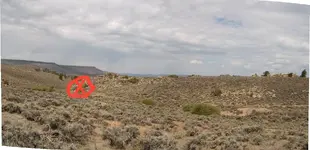
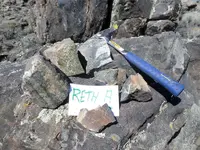
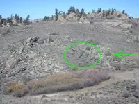
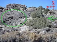
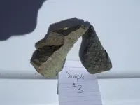
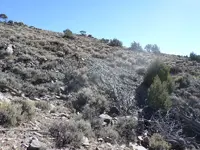
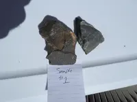
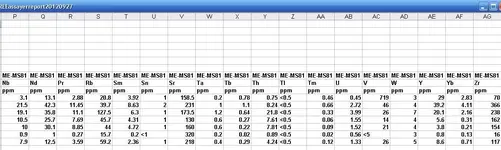
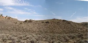
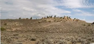
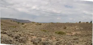
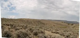
In August, I drove to the location and walked an area of 3-4 football fields smacking off rock samples with my Estwing hammer. REE minerals generally look like plain dirt in most of their natural occurrences, so to really verify my results I knew had to send samples off to a laboratory for analysis. That wasn’t cheap, but I did it to fulfill the project.
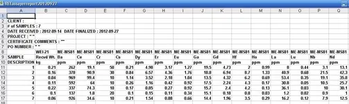
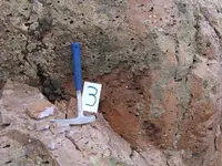
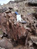
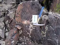
I’ve attached photos of the Excel spreadsheet (2 images, left-to-right) laboratory results for rare earth elements. You can see that Ce and La are the principal REEs found. The mineral bastnaesite would be a possible match with the findings. A mining engineer friend of mine has reviewed the values and evaluated them as a rare earths occurrence, but not of economic consequence.
If I go back, I intend to explore in the direction of samples 2 and 3 for possibly higher grade material. The trip was a true educational experience for me with respect to mineral identification and sampling.
Good luck out there folks. I hope your projects are successful.
Sincerely,
Cochetopa
p.s. It’s getting cold here in Colorado, so my field trips may be coming to a stop until next spring. We’ll see how hardy I am.
Some months back, my wife returned from a meeting where a geologist spoke about how my region of Colorado was favorable for the occurrence of rare earth elements, REEs. Also, he spoke about how communist China has a strangle hold on the world’s production of these materials. I already knew the second part, but it tick’d me off anyway. So, I decided to try a prospecting project for REEs.
You can read more about rare earth elements and their occurrence in the US here, USGS Scientific Investigations Report 2010-5220: The Principal Rare Earth Elements Deposits of the United States?A Summary of Domestic Deposits and a Global Perspective
There is a discussion of REEs in Colorado around pp 41-48.
I grabbed my pendulum and my ancient Boy Scout compass. Sitting down for dowsing, I asked, “Is there an undiscovered rare-earth ore deposit nearby which you want me to have now?” I purposely used the term “ore deposit” because a mining engineer will tell you its definition is “any mineral occurrence which can be mined profitably under current economic conditions”. I wanted a location which had potential for a working mine. Anyway, I obtained an azimuth, and then dowsed using my pendulum for a distance. The distance surprised me because the dowsing process apparently interpreted “nearby” rather figuratively, i.e. the target wasn’t within a day trip’s driving distance from my home. (Life issues force me to be at home during evenings right now.) I was disappointed I would not be driving out to verify the dowsing results anytime soon.
Sometime later, I decided to try again, but constrain the search area to MY interpretation of “nearby” by using the pile-of-maps technique which I have described in my previous postings on Tnet Dowsing forum. I also wasn’t so hard-nosed about the ore deposit thing, I just wanted a REE occurrence which I could go onsite to verify proof of concept. I started dowsing with 1:100,000 scale BLM Surface Management maps, and by triangulation work with my L-rod eventually had the location identified on a 1:24,000 scale USGS topo map.
In August, I drove to the location and walked an area of 3-4 football fields smacking off rock samples with my Estwing hammer. REE minerals generally look like plain dirt in most of their natural occurrences, so to really verify my results I knew had to send samples off to a laboratory for analysis. That wasn’t cheap, but I did it to fulfill the project.
I’ve attached photos of the Excel spreadsheet (2 images, left-to-right) laboratory results for rare earth elements. You can see that Ce and La are the principal REEs found. The mineral bastnaesite would be a possible match with the findings. A mining engineer friend of mine has reviewed the values and evaluated them as a rare earths occurrence, but not of economic consequence.
If I go back, I intend to explore in the direction of samples 2 and 3 for possibly higher grade material. The trip was a true educational experience for me with respect to mineral identification and sampling.
Good luck out there folks. I hope your projects are successful.
Sincerely,
Cochetopa
p.s. It’s getting cold here in Colorado, so my field trips may be coming to a stop until next spring. We’ll see how hardy I am.


Attachments
-
 assayReport01.webp57.5 KB · Views: 181
 -
 assayReport02.webp49.3 KB · Views: 172
 -
 EasterlyPanorama.webp145.3 KB · Views: 179
 -
 NorthPanorama.webp158.2 KB · Views: 175
 -
 NorthWestView.webp130.4 KB · Views: 162
 -
 SouthWestView.webp121.7 KB · Views: 188
 -
 Sample3.webp187.2 KB · Views: 198
 -
 Sample2.webp171 KB · Views: 253
 -
 Sample1.webp190.4 KB · Views: 251