Heart Rock

aarthrj3811

Gold Member
Apr 1, 2004
9,256
1,169
Northern Nevada
Detector(s) used
Dowsing Rods and a Ranger Tell Examiner
I just added this stone to my collection of heart rocks...the only thing I know is that this is a Spanish Treasure Marker..Any help would be appreciated...
IMG_0106.jpg
 

OP
OP
aarthrj3811

aarthrj3811

Gold Member
Apr 1, 2004
9,256
1,169
Northern Nevada
Detector(s) used
Dowsing Rods and a Ranger Tell Examiner
I guess you are right...This guy put this one in the fireplace he built in his new house..Art
DSC00264.jpg
 

Red_desert

Gold Member
Feb 21, 2008
6,855
3,507
Midwest USA
Detector(s) used
Garrett Ace 250/GTA 1,000; Fisher Gold Bug-2; Gemini-3; Unique Design L-Rods
Primary Interest:
All Treasure Hunting
This one is in the front flower garden where I found it after moving here. We are far away from any Spanish sites, but an Indian village used to be close by. They helped Tecumseh fight the war of 1812, the Shawnee princess daughter of Tecumseh's brother chief Elkhart, lived in the area. Her name was Mishawaka and a town named after her. A couple plow scars, a heart and T on the other side.....possibly a rune also. I've posted these pics before on TreasureNet, not sure when or where the thread is posted.
 

Attachments

  • heartcarving1.jpg
    heartcarving1.jpg
    65.3 KB · Views: 143
  • heartcarving2.jpg
    heartcarving2.jpg
    80.6 KB · Views: 161
OP
OP
aarthrj3811

aarthrj3811

Gold Member
Apr 1, 2004
9,256
1,169
Northern Nevada
Detector(s) used
Dowsing Rods and a Ranger Tell Examiner
Hey Red....I would not disregard any Spanish Markers that you find....I have found them in most of the USA ...Turtles seem to be all over the place...The second photo the guy found a big treasure...This one has me confused....Art
 

Red_desert

Gold Member
Feb 21, 2008
6,855
3,507
Midwest USA
Detector(s) used
Garrett Ace 250/GTA 1,000; Fisher Gold Bug-2; Gemini-3; Unique Design L-Rods
Primary Interest:
All Treasure Hunting
Mine is very close to what the French explorers called "Miamis River" portage. The name of the river "Miami (Miamis)" later was changed to Elkhart. The river at the other end, flowed around a piece of land which is heart shaped at the point it empties into the Saint Joseph river. A city park is there on the island now. The owner of a treasure shop in lower Michigan told me he found what looked like to be a copper culture artifact (think it was a point) metal detecting at the park.
 

Last edited:
OP
OP
aarthrj3811

aarthrj3811

Gold Member
Apr 1, 2004
9,256
1,169
Northern Nevada
Detector(s) used
Dowsing Rods and a Ranger Tell Examiner
Hey Del...the marker as not been moved...There are some electrical lines near by that may give you some interference....If the gold is not under two foot it may not be there....Art
 

pebble

Jr. Member
Apr 25, 2006
79
40
Texas
Detector(s) used
TM808, Arc geo logger
Primary Interest:
Cache Hunting
The heart has not been moved, it is laying in the exact place it was found, it had been buried. Thank, Del
 

Treasure finder

Sr. Member
Apr 4, 2006
464
60
Los Angeles
Detector(s) used
Garrett Infinium, Compass Gold Scanner, Maxi Pulse, Gardner with a 3 foot loop, PDF1000, & Dowsing rods,
Art,
I have found a fair amount of Spanish Heart Rocks, usually large immoveable boulders. Usually they mark a trail, not a final treasure
spot and usually there are other signs within a short walk and frequently have signs on the back such as faces or an X.
This one could be a private one left by one of the miners for his own use, not to guide others back.
Rich
 

Produce Guy

Bronze Member
Dec 17, 2008
2,131
519
austin,texas
🏆 Honorable Mentions:
1
Detector(s) used
Garrett Ace250,garrett pro-pointer,AT/Pro,
Primary Interest:
All Treasure Hunting
I've been on this site since 2008 and it seems that every once in awhile someone finds a heart shaped rock,I've found a couple here in Texas,but not that big.
 

Red_desert

Gold Member
Feb 21, 2008
6,855
3,507
Midwest USA
Detector(s) used
Garrett Ace 250/GTA 1,000; Fisher Gold Bug-2; Gemini-3; Unique Design L-Rods
Primary Interest:
All Treasure Hunting
I have another heart rock to share. It looks too much of a V-shape to be natural. There seems to be visible light spots inside of left side, possibly quartz. The only way anyone could have made this would be to make a special shaft going up, possibly with steps, then take down the outside edge to the surface leaving it open.

These photos are from the Needles Canyon area of the Superstition mountains. All the people who claimed to have found the Lost Dutchman mine I've been told are dead. Best advice is to take only photos, leave it for future generations to enjoy.

I put the cropped heart opening next to the carved heart symbol from my location. Boxes also show where a possible shaft may have been. Above is a stone formation high on the cliff face, appears to be looking as if watching you. It can been seen when looking west across the gulch.
 

Attachments

  • heartshapedhole.jpg
    heartshapedhole.jpg
    160.4 KB · Views: 159
  • RHarea - Looking W across Gulch(crop)LG.jpg
    RHarea - Looking W across Gulch(crop)LG.jpg
    614.8 KB · Views: 216
  • RHarea - Looking W across Gulch(crop)LG-A.jpg
    RHarea - Looking W across Gulch(crop)LG-A.jpg
    412.5 KB · Views: 156
  • RHarea - Looking W across Gulch(crop)LG-B2.jpg
    RHarea - Looking W across Gulch(crop)LG-B2.jpg
    337.2 KB · Views: 159
  • RHarea - Looking W across Gulch(crop)LG-B3.jpg
    RHarea - Looking W across Gulch(crop)LG-B3.jpg
    204.7 KB · Views: 154
Last edited:

Red_desert

Gold Member
Feb 21, 2008
6,855
3,507
Midwest USA
Detector(s) used
Garrett Ace 250/GTA 1,000; Fisher Gold Bug-2; Gemini-3; Unique Design L-Rods
Primary Interest:
All Treasure Hunting
I might add also, this was a dowsing project using GE maps. I was supposed to go on the trip, but couldn't make it because my mother fell hurting her back. The treasure hunter wanted me along to use my L-rods. Now he plans to stay away from the LDM area for at least 1 year.

A retired PH D scientist used IR satellite technology to identify where gold can exist in the Superstition mountains. The line box is around the only place found by satellite. The west end goes into Needles Canyon at one spot. The Peralta mines are a part of the diamond shaped alteration zone also.

The heart hole is right on the edge of alteration geology, in the west part where veins are possible. I'm adding a close up of it, enlarged to the maximum.

Edit; (I've added the telephoto shot here of the cave like opening mentioned in the post below because had browse file tabs used up. He didn't think it was more than just a hole, after enlarging the pic some at home. Until a person goes up there, you won't really know for sure. This looks to be different than the 2nd or other mentioned in post below, heart shaped opening)
 

Attachments

  • Aster_1_LDM_New_Alter-Zone_crop.jpg
    Aster_1_LDM_New_Alter-Zone_crop.jpg
    310.8 KB · Views: 154
  • RHarea - Looking W across Gulch(crop)LG-B4.jpg
    RHarea - Looking W across Gulch(crop)LG-B4.jpg
    210.8 KB · Views: 152
  • Rock House area Cliff Wall 1.JPG
    Rock House area Cliff Wall 1.JPG
    493.6 KB · Views: 167
Last edited:

Red_desert

Gold Member
Feb 21, 2008
6,855
3,507
Midwest USA
Detector(s) used
Garrett Ace 250/GTA 1,000; Fisher Gold Bug-2; Gemini-3; Unique Design L-Rods
Primary Interest:
All Treasure Hunting
Looking to the south, here is where dowsing hits in GE seemed to be the rock house. Of course, the Forest service rangers may have blown it up.

Another opening also. He tried getting a telephoto shot, of what seemed to be a cave, but can't really tell from pics. Going down the wash side a little, to check out another possible cave, slipped scratching his camera lens.

Included is a shot of going up the wash, the deadliest scorpions were hard to see because their color blends in with the rocks so well. You must wear leather gloves to get up to the top of wash. Boxes show the spot might be carved out to anchor the back rock house wall. He tried to get up there, but ledge doesn't let you.....if a rock house had been built this spot, it would make it possible to get on the ledge, then walk to the other opening.

The other opening, it appears to be a different one than was captured in the telephoto shot. It must be above the ledge where looks possibly chopped away, maybe if a vein was exposed got taked down so people couldn't see it.

A thorn tree or bush with 2" thorns is so thick growing in front of this spot, you can't get through except crawling under a couple places. He calls them cat's claw and each thorn draws blood.

Red and white boxes show where notched out rock might be the rock house location. We had expected these dowsing hits in GE maps to be it, so here is the results of checking GE map hits.
 

Attachments

  • RH-area South(crop)-B.jpg
    RH-area South(crop)-B.jpg
    592.3 KB · Views: 164
  • RH-area South(crop)-C.jpg
    RH-area South(crop)-C.jpg
    356.3 KB · Views: 158
  • RH-area Cliff Wall 2.JPG
    RH-area Cliff Wall 2.JPG
    1 MB · Views: 157
  • RH-area Cliff Wall 2crop.jpg
    RH-area Cliff Wall 2crop.jpg
    936.6 KB · Views: 163
  • Going Up 1crop.jpg
    Going Up 1crop.jpg
    1.2 MB · Views: 136
Last edited:

Red_desert

Gold Member
Feb 21, 2008
6,855
3,507
Midwest USA
Detector(s) used
Garrett Ace 250/GTA 1,000; Fisher Gold Bug-2; Gemini-3; Unique Design L-Rods
Primary Interest:
All Treasure Hunting
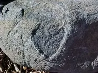
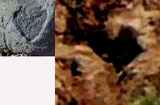
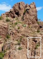
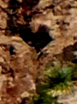
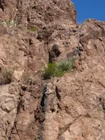
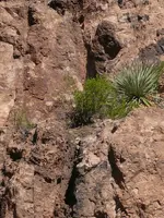
I've been told there are 2 known LDM maps showing a rock face which is said, "to look in the direction of the Lost Dutchman Mine". I cropped and put a red circle around the part of the rock formation I'd meant seemed to be looking. You can see why they call it the Superstition Mountains.

(Edit: I've added some more info here.)

Going back over my files, found something very important. In one of the emails from this retired PH D scientist, once he was late getting home from a hike, hoping to reach the LDM area. His wife called the Search and Rescue, because she was worried. While they had already started looking with flashlights in the dark, from around near the parking place, the retired scientist returned safely. Getting out his notes (with maps I'd dowsed), showed my maps to one person on the search team, who said that he had done rescue for 30 years now.

Here are a couple quotes from the emails, reasons why I believe this should be part of the Lost Dutchman mine site.

"I tried to get to the LDM area we found from the satellite maps on 6/24 but couldn’t get there in time. It took me seven hours (it was over 100F and no wind) to get five miles in. I could see Needles Canyon and the area where the rock house may be but it was another 1.2 miles as the path goes and I couldn’t make it as it was getting too late. On the way back I got overheated from the 40# pack I was carrying and the 1500’ uphill climbing. It took me ten hours to get back and my wife got so worried she called the Search and Rescue. So at 9:30 PM limping back I was within a mile of the parking lot and I met a team of nine people with flashlights looking for me…

The fellow leading the Rescue team said he had been over every inch of Needles Canyon over the last 30 years (he was born and raised in Apache Junction) and said there was a rock house built into a small cave in the area I was headed to but the Forest Service blew the rock house part up 15 to 20 years ago. He also said across the canyon from it was a huge cave that went way back in the mountain. "

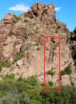
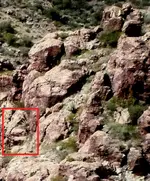
"When I was out there on June 24, 2013 (I got within sight of Needles Canyon
but couldn't make it and had to turn around and come back) I saw this
unusual rock and I took a picture of it. This is a view looking NW from
where I turned around on the Terrapin Trail. I took two shots, one a wide
angle shot and one telephoto shot. I attached a copy of the telephoto shot.
This rock was facing East toward Needles Canyon (close to where the LDM may
be - in the direction where I think the gold vein may be located in the
gulch and you found three orange circles).

What do you think this rock looks like?

It's interesting that if you look at this point using Google Earth you don't
see anything. Notice in the picture how high the rock stands ABOVE the
mountain ridge. The top of the rock is about 20' above the ridge but the
entire rock is over 100' tall.

(Please note, I've not added this photo to the post, it probably isn't the same rock formation.)

One of the clues the Dutchman left was - there is a stone face (facing East)
that looks right at the mine. This is shown on one of the old maps I have
but the perspective is when its viewed from the North (not the SE as I was
when I took the picture)."

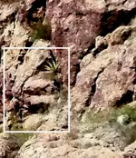
"Several of the old stories relate the mine being near water (or a small spring). There are several small springs in that narrow gulch canyon and the very first is the “Y” shaped canyon (Map 32) the water runs North toward the suspected Rock House area, Pin LDM_1E. The last spring (or “weep” as the flow is very small) just beyond (North of) the LDM_1E Pin."

"Because of the time constraints my primary objective is going to be the Rock
House area/cave. Then if I have any time left over I can check out the
three Red circle area right across the gulch from the Rock House area....

Map you found hits on both sides of the gulch [the Rock House cave on the left side (West) and three Red circles and an Orange circle on the right side (East) ]. I am planning on checking out both sides of the gulch when I go there with the highest priority being the Rock House cave."
 

Attachments

  • Rock_facecropA.jpg
    Rock_facecropA.jpg
    298.6 KB · Views: 138
Last edited:

Top Member Reactions

Users who are viewing this thread

Top