Amazing Research Discovery!!!

Stone

Sr. Member
Joined
Feb 26, 2012
Messages
309
Reaction score
291
Golden Thread
0
Location
Mississippi
Detector(s) used
Teknetics Delta 4000
Primary Interest:
Metal Detecting
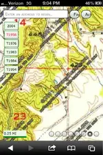
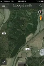
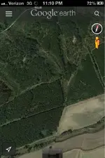
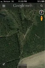
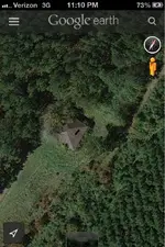
I was looking at an old topographical map of my area from 1956 and noticed an old road with a house on it. I located the house on google earth, it appears to have been abandoned. I need to find out who owns this property so I can detect it. The topo also shows an unoccupied building near by the house. Here are some pics of the area. I'm very exited right now and really want to see it in person.
 

Attachments

  • image-2263188784.webp
    image-2263188784.webp
    64.3 KB · Views: 143
  • image-2073404454.webp
    image-2073404454.webp
    57.8 KB · Views: 148
  • image-4217824125.webp
    image-4217824125.webp
    65.5 KB · Views: 141
  • image-2630450506.webp
    image-2630450506.webp
    74.4 KB · Views: 119
  • image-3139811401.webp
    image-3139811401.webp
    78 KB · Views: 123
Upvote 0
Good luck to you. I would suggest that you be cautious about posting the specifics or even a portion of a map. Easy for people to figure out a location and poach your area.
 

Good luck to you. I would suggest that you be cautious about posting the specifics or even a portion of a map. Easy for people to figure out a location and poach your area.

Not really worried about it. If someone wants to do that than good luck to them. I have more places to hunt, I don't have a detector that can hunt them anyways.
 

Check with your local county tax assessor plat maps. They will show who pays the taxes on that particular piece of land.
 

Historicaerials.com has some nice old aerial shots you can overlay too.
 

I did something similar and found a barn on 1940's aerial map next door to my sisters house.
 

Top Member Reactions

Users who are viewing this thread

Back
Top Bottom