gldnbrew
Full Member
- Joined
- Feb 16, 2013
- Messages
- 152
- Reaction score
- 172
- Golden Thread
- 0
- Location
- The 1000 Islands, NY
- Detector(s) used
- Garrett AT Pro and ATMax, 8.5 x 11, 5 x 8 & a Super Sniper - Pro-pointer.
Fisher F75 LTD, XP Deus - 11", Garrett AT and AT ZLINK pointer
Minelab equinox 900 - 11” and 6”
- Primary Interest:
- Relic Hunting
- #1
Thread Owner
In reading Coinman123 and Detecto's post on their research, I thought I would offer something I discovered quite by accident. In my search for old homesteads I was using Google Earth and overlays to find coordinates for the areas to search. However, my main research project has been a local battle of the War of 1812, and with around 300 artifacts cataloged and GPS'ed I needed some way of laying out all the shot I have recovered with terrain features. I had been using Google Earth, but as you know laying this out in Google Earth, if the area is in the woods, all you get is trees. In talking with other researchers it was suggested I use a GIS program, searching the internet I found a FREE GIS program called QGIS.
Having never used a GIS program before,I needed some instruction, thank you YouTube. Here is what you are going to need: QGIS, and a 1 meter DEM (LIDAR) image. Fortunatly here in NYS we have access to the 1 meter DEM, but they are also available for most areas, you will just have to look for them. When you get QGIS I recommend that you do this tutorial - QGIS - for Absolute Beginners
This tutorial covers everything you need to get started.
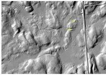
My discovered secondary use for QGIS and I say a very valuable tool for us relic hunters, in which a 1 meter DEM is great for finding the actual location of old homesteads, roads, and fences which appear on old maps, and which can not be seen in Google Earth. Here is the procedure - Download the DEM for that location,and bring into QGIS>highlight it > go to raster (on tool bar) > to Terrain Analysis > hillshade or you can highlight and right click > select properties > select style > change singleband gray to hillshade. Once in hillshade you will be able to find old cellar holes and other features, some will be more obvious than others, for the unobvious look for shapes that do not appear in nature.] Photos below:
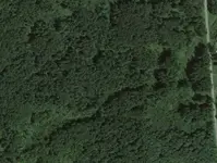
 Here is the Google Earth Photo
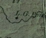
  With overlay
  QGIS hillshade
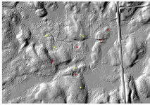
 My locations to hunt
As you can see Google Earth offers you nothing but woods, and even with the overlay it is questionable where the old homestead was on the 1864 map. Looking at the hillshade you can clearly see all the features, fences, old roads, streams and an unexpected 2 cellar holes (Yellow arrows) also note the old road that comes from the main and continues to the second cellar hole none of which is visible in Google Earth. The last photo shows my GPS locations to hunt. Yellow dots are before QGIS and red ones after, but I am going to check them all out. Thanks to QGIS I have found several new locations, that were not visible in Google Earth, and have been able to pinpoint them with my GPS.
I hope this information will help someone.
PS: QGIS can also do infrared from 4 band imagery, which can be useful depending on what you are looking for, and depending on the season of the year the image was taken.
Having never used a GIS program before,I needed some instruction, thank you YouTube. Here is what you are going to need: QGIS, and a 1 meter DEM (LIDAR) image. Fortunatly here in NYS we have access to the 1 meter DEM, but they are also available for most areas, you will just have to look for them. When you get QGIS I recommend that you do this tutorial - QGIS - for Absolute Beginners
This tutorial covers everything you need to get started.
My discovered secondary use for QGIS and I say a very valuable tool for us relic hunters, in which a 1 meter DEM is great for finding the actual location of old homesteads, roads, and fences which appear on old maps, and which can not be seen in Google Earth. Here is the procedure - Download the DEM for that location,and bring into QGIS>highlight it > go to raster (on tool bar) > to Terrain Analysis > hillshade or you can highlight and right click > select properties > select style > change singleband gray to hillshade. Once in hillshade you will be able to find old cellar holes and other features, some will be more obvious than others, for the unobvious look for shapes that do not appear in nature.] Photos below:
 Here is the Google Earth Photo
  With overlay
  QGIS hillshade
 My locations to hunt
As you can see Google Earth offers you nothing but woods, and even with the overlay it is questionable where the old homestead was on the 1864 map. Looking at the hillshade you can clearly see all the features, fences, old roads, streams and an unexpected 2 cellar holes (Yellow arrows) also note the old road that comes from the main and continues to the second cellar hole none of which is visible in Google Earth. The last photo shows my GPS locations to hunt. Yellow dots are before QGIS and red ones after, but I am going to check them all out. Thanks to QGIS I have found several new locations, that were not visible in Google Earth, and have been able to pinpoint them with my GPS.
I hope this information will help someone.
PS: QGIS can also do infrared from 4 band imagery, which can be useful depending on what you are looking for, and depending on the season of the year the image was taken.


 . I did the place marker thing on google earth to make a map of each homestead. I cant wait to try your program.