BosnMate
Gold Member
- Joined
- Sep 10, 2010
- Messages
- 6,916
- Reaction score
- 8,441
- Golden Thread
- 0
- Detector(s) used
- Whites MXT, Whites DFX, Whites 6000 Di Pro
- Primary Interest:
- Other
- #1
Thread Owner
I posted a photo of a mule deer fawn a few days ago. The picture was taken on the eastern flank of Beatys Butte, in the southeastern high desert of Oregon. These photos I'm posting now, and the story about them took place just after Jimmy Carters presidency, and the gas shortage was still a fresh memory, which at the time was important because of the remoteness of the area we were hunting. In fact, because of the past shortage, many gas stations, especially rural stations, went out of business.
There are antelope in Oregon, just not like Wyoming where they have lots of them. In order to get an Oregon tag, you have to apply, and then be drawn, and it took me 11 years to finally get a tag for the East Beatys Butte game management unit, so this hunt was taken quite seriously by yours truly. And I might ad, I've never got another one. In the post showing the mule deer fawn I mentioned the isolation of that particular place, so this time I'll show a map of the approximate location of Beatys Butte, just north of the Nevada state line.
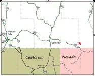
An interesting side note regarding gas at that time. Just north of Lakeview, at the junction where we turned off 395 onto 140, there was a sign that said, "Next Gas 200 miles." That gas would be found at Denio Junction in Nevada, about 100 miles from where we would be hunting. Giving full discloser, we actually went to Beatys Butte twice, once before season on a weekend scouting trip and then a week or so later for the hunt, so all together, combining the two trips, we were in that area for over a week.
We stayed at Actly cow camp, which at the time was not being used by anyone else. There was water there, which was a big plus, and all and all, I think our stay there was very comfortable.
In those days I was using a film camera, so I didn't take near as many pictures as I would now with the digital camera.
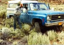
During the scouting weekend, we were on a road of sorts, coming down a hill where the rancher had put out salt for the cows. I managed to run my truck up onto a rock, and it was resting on the frame. We got the truck off with no damage done, but you don't want to take that desert for granted, and I had to take some serious teasing over it.
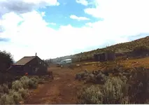
This is Actly Cow Camp. I stayed in the cabin.
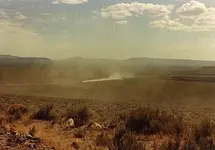
This is my friend, making a long dust in the desert. That country is tough on vehicles.
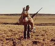
It was a hunting trip, and I filled my tag. Note the lava rocks in that field. There just isn't any driving across country along there, as far as that goes, the road out to that location wasn't much better than the field. That lava is not smooth cobbles, it's sharp, tire cutting stuff.
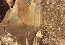
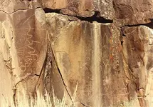
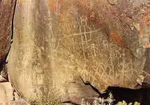
The day before I killed the antelope, I was hunting in Sage Hen Canyon, ran into these pictographs, so after my tag was filled, I went back and took photos, and looked around a bit.
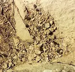
Found this spot where someone had sat and flaked tools. The black flakes are obsidian, and if you look close there is a red flake also.
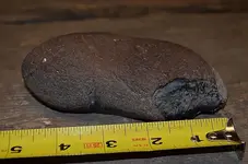
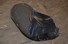
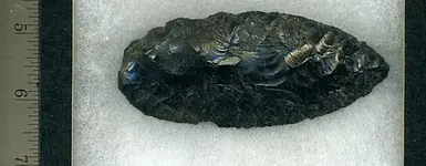
The rancher had taken a cat into the canyon at the location of a spring, and dug out a water tank that was fed by the spring. On top of the ground where the cat had pushed it out I found this.
There are antelope in Oregon, just not like Wyoming where they have lots of them. In order to get an Oregon tag, you have to apply, and then be drawn, and it took me 11 years to finally get a tag for the East Beatys Butte game management unit, so this hunt was taken quite seriously by yours truly. And I might ad, I've never got another one. In the post showing the mule deer fawn I mentioned the isolation of that particular place, so this time I'll show a map of the approximate location of Beatys Butte, just north of the Nevada state line.

An interesting side note regarding gas at that time. Just north of Lakeview, at the junction where we turned off 395 onto 140, there was a sign that said, "Next Gas 200 miles." That gas would be found at Denio Junction in Nevada, about 100 miles from where we would be hunting. Giving full discloser, we actually went to Beatys Butte twice, once before season on a weekend scouting trip and then a week or so later for the hunt, so all together, combining the two trips, we were in that area for over a week.
We stayed at Actly cow camp, which at the time was not being used by anyone else. There was water there, which was a big plus, and all and all, I think our stay there was very comfortable.
In those days I was using a film camera, so I didn't take near as many pictures as I would now with the digital camera.

During the scouting weekend, we were on a road of sorts, coming down a hill where the rancher had put out salt for the cows. I managed to run my truck up onto a rock, and it was resting on the frame. We got the truck off with no damage done, but you don't want to take that desert for granted, and I had to take some serious teasing over it.

This is Actly Cow Camp. I stayed in the cabin.

This is my friend, making a long dust in the desert. That country is tough on vehicles.

It was a hunting trip, and I filled my tag. Note the lava rocks in that field. There just isn't any driving across country along there, as far as that goes, the road out to that location wasn't much better than the field. That lava is not smooth cobbles, it's sharp, tire cutting stuff.


The day before I killed the antelope, I was hunting in Sage Hen Canyon, ran into these pictographs, so after my tag was filled, I went back and took photos, and looked around a bit.

Found this spot where someone had sat and flaked tools. The black flakes are obsidian, and if you look close there is a red flake also.
The rancher had taken a cat into the canyon at the location of a spring, and dug out a water tank that was fed by the spring. On top of the ground where the cat had pushed it out I found this.


