Each beach, in various different locales, follows slightly different "rules". So for example, you being in Miami, might look for a different combination of weather-related ingredients to know when your beaches might be eroding, than someone in central-coast CA. Because each beach "acclimates" to it's own set of "norms". Mother nature creates here slopes, type of sand grains, etc... to eventually be a "norm", for the average normal conditions of any particular beach. That's why 20 ft. seas up in northern Washington, might be their winter "norm", and do nothing appreciable to their beaches (or the extent that it erodes severely, it does nothing but expose last year's zinc pennies, because it ROUTINELY gets down that deep, etc...). But if that same "20 ft." seas were to hit normally calm "baywatch" condition beaches of Southern CA (Malibu, Hunnington Beach, etc...) you can bet it'd go down to stratas not seen in many decades.
So your question is highly subjective.
But in general: It's swells, seas, on-shore-winds, and tides, that combine to cause erosion. And yes, the sand just moves latterally down the beach. It might be held off-shore in sand bars for a few days or weeks, and then comes ashore down-stream a bit. The trick is to get into the pockets where it's been removed, so that hopefully mother nature has created a "riffle board" action, and left the heavier targets till on the beach, while taking the lighter sand out

High tides are important, because even with the ROUGHEST seas, if it occurs at the low-tide time of the day, then those rough seas/waves are just bashing around at the inter-tidal flat zone, which is already ......... daily .... acclimated to getting waves. So ideally, you want the rough seas, on-shore swells and waves, to occur at the astronomical high tide times, so that it's bashing around at normally higher drier sand, which doesn't normally see salt water. So that unlike the low tide zones, where the water can just continue to roll up higher, at the foot of the dunes, that same water has no place to go but DOWN and erode, hopefully (unless it does an "up and over" number, which is another story altogether).
Get yourself one of those radio shack weather scanners, and listen to the loop recording during the storm season. Pay close attention to the direction of the swells and wind, to make sure your particular beaches are "shadowed" by land obstructions. Ie.: look at a map of your entire coast line, for hundreds of miles along, and draw compass lines, and you will see what I mean by "shadowing" effect. Because surf does not "turn corners", so to speak.
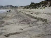
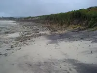
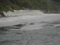
And finally, hard knocks experience and trial and error will show you once and for all what to look for, on your particular beaches. Here's some pix of erosion here: