You are using an out of date browser. It may not display this or other websites correctly.
You should upgrade or use an alternative browser.
You should upgrade or use an alternative browser.
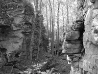
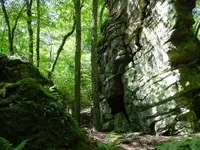
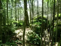
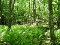
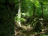
Beartown, wild and wonderful WV.
- Thread starter Th3rty7
- Start date


fossis
Gold Member
- Joined
- Jan 5, 2007
- Messages
- 7,837
- Reaction score
- 98
- Golden Thread
- 0
- Location
- eastern Oklahoma
- Detector(s) used
- Whites Prizm 11 & White's XLT
- Primary Interest:
- All Treasure Hunting
I can see why, nice place for a hike.
Fossis.............
Fossis.............
- Joined
- Jan 27, 2009
- Messages
- 18,871
- Reaction score
- 12,119
- Golden Thread
- 1
- Location
- South East Tennessee on Ga, Ala line
- 🥇 Banner finds
- 1
- Detector(s) used
- Tesoro Conquistador freq shift
Fisher F75
Garrett AT-Pro
Garet carrot
Neodymium magnets
5' Probe
- Primary Interest:
- All Treasure Hunting
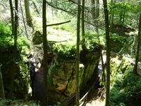
Wow if that place could talk. I wonder how many ancients passed between those gaps. It is a very beautiful place and looks like it could tell many a story.
TnMtns
TnMtns
Woodland Detectors
Gold Member
- Joined
- Nov 23, 2008
- Messages
- 12,712
- Reaction score
- 142
- Golden Thread
- 0
- Location
- Toll Free ~ 855~966~3563
- 🏆 Honorable Mentions:
- 1
- Primary Interest:
- Relic Hunting
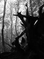
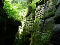
That third photo is amazing!
naturegirl
Bronze Member
my kinda place!
ng
ng
DanL
Jr. Member
Nice! If it wasn't a 5 hour drive from my house, I'd pay a visit (was hoping it was in northeastern WV). It looks like you took those pictures quite a few years ago. Do you still go back there regularly and if so, is it still relatively unspoiled?
Th3rty7
Silver Member
- #7
Thread Owner
TnMountains said:Wow if that place could talk. I wonder how many ancients passed between those gaps. It is a very beautiful place and looks like it could tell many a story.
TnMtns
agreed Tn, you get that feeling when your there.
thanks for the comments guys and gals.
Dan, it's been a few years since I've been back, there are many parts of wv that are unspoiled and untravelled, just got to get off the beaten path. I'm considering driving up there this afternoon, I'll bring the camera along and update this post later this evening.
Drudge
Full Member
- Joined
- Nov 19, 2007
- Messages
- 180
- Reaction score
- 13
- Golden Thread
- 0
- Location
- Connecticut
- Detector(s) used
- Minelab: eTrac, Excalibur II, Sovereign GT
- Primary Interest:
- All Treasure Hunting
Looks amazing. I could see taking my mountain bike through there 
DanL
Jr. Member
Cool! Looks like the place hasn't changed much in the 7-8 years since you took that last set of pics. Sure wish it was closer.
Excavator
Hero Member
- Joined
- Oct 18, 2006
- Messages
- 513
- Reaction score
- 0
- Golden Thread
- 0
- Location
- West Virginia
- Detector(s) used
- Bounty Hunter
I'm always drawn to places like that. Have yet to MD any of them at all, but have some picked out. Will post pics as soon as I get them. One spot, has names and dates carved in the 19th century.
Had a little cabin built beneath a rock overhang when I was a kid.. er young kid.
Great shots!
Had a little cabin built beneath a rock overhang when I was a kid.. er young kid.
Great shots!
Mental Granny
Gold Member
- Joined
- May 8, 2005
- Messages
- 10,072
- Reaction score
- 115
- Golden Thread
- 0
- Location
- Cherokee Strip
- Detector(s) used
- Cibola
- Primary Interest:
- All Treasure Hunting
I agree that is a place I would love to see sometime, I beleive may have passed that way!
Th3rty7
Silver Member
- #13
Thread Owner
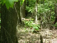
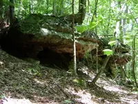
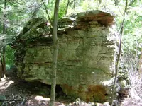
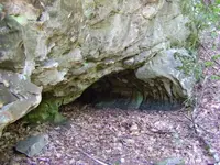
Appreciate the comments everyone. I got off the tourist trail and found some interesting places that would make an md'er or artifact hunter drool. The first pic is a rock shelter, 2nd pic is about 50 yards from that is a really old civil war era fence, and behind the fence is a natural limestone ravine that could have easily been some type of fort. I say this because the fence is right in front of the ravine and faces the only opening on the ridge that overlooks a field.
Attachments

Mental Granny
Gold Member
- Joined
- May 8, 2005
- Messages
- 10,072
- Reaction score
- 115
- Golden Thread
- 0
- Location
- Cherokee Strip
- Detector(s) used
- Cibola
- Primary Interest:
- All Treasure Hunting
Fantastic shots I really do want to go there!  Do you know any history of the people who traveled or lived there?
Th3rty7
Silver Member
- #15
Thread Owner
beale said:thirty7, do you now live in Beartown, WVa? I was born and raised about 8 miles from there up the Little Sandy River, a town by the name of Raysal. The town was named for Ray Salvadus. Those photos you have there were they taken on the river side of the mountain or on the Panther State Forest on the other side of the mountain? I have been in every nook and cranny, every hollow and spur within fifty miles of Beartown as a youngster searching for wild ginseng. I have searched in Panther State Forest also, beautiful country except for the Japanese hornets, rattlesnakes, copperheads and an occasional bear or two. I have hunted ginseng on Whiteoak, Preacher's Fork, Slick Rock, Big Lick and other streams in Panther State Forest. If you go to the top of Beartown mountain and turn to the left along the ridge road you will end up on Bradshaw Mountain on State Line Ridge near a place called Estepp Ridge. The ridge was named for my grandmother's people on my dad's side of the family. My gggrandfather was shot and killed on the ridge during the Civil War while holding my ggrandmother in his arms. All told during the war over 35 of my ancestors on that side of the family was killed holding the line between the North and the South after West Virginia separated from Virginia on June 20, 1863.
Keep posting the great pictures. Where exactly is that trail located? I know I have been there but the location fells from my memory. Again thanks for the great pictures and taking me back home if only in memory.
Hello Beale, I enjoyed your post, and the area you're talking about is on the opposite side of the state as this Beartown is in the far eastern side of West Virginia in Pocahontas county. I've been to panther state park and the scenery is quite similar , really nice country. I'm from Greenbrier county originally , but now live in western Va.
RGINN
Gold Member
- Joined
- Oct 16, 2007
- Messages
- 8,948
- Reaction score
- 12,271
- Golden Thread
- 0
- Location
- Summit County, CO
- 🏆 Honorable Mentions:
- 1
- Detector(s) used
- White's DFX, White's Classic 1 Coinmaster, Nokta Pointer
- Primary Interest:
- All Treasure Hunting
Aw man, wish I could go there and camp for a few days and explore. Maybe in my next life. Cool pics of a cool place.
civil war hunter
Hero Member
- Joined
- Feb 10, 2009
- Messages
- 990
- Reaction score
- 15
- Golden Thread
- 0
- Location
- west virginia
- Detector(s) used
- whites classic 5 id, and bounty hunter.
Well i tell you guys what ill go hiking soon. Ill take my camera. Don't be scared when i show the biggest freaking hill that i climb.
Top Member Reactions
-
 2214
2214 -
 1588
1588 -
 1394
1394 -
 1247
1247 -
 1198
1198 -
 1062
1062 -
 990
990 -
 781
781 -
 776
776 -
 613
613 -
 566
566 -
 540
540 -
 518
518 -
 496
496 -
 487
487
Similar threads
Users who are viewing this thread
Total: 1 (members: 0, guests: 1)
