Crooked island passage and shipwrecks

SADS 669

Bronze Member
Joined
Jan 20, 2013
Messages
2,454
Reaction score
3,742
Golden Thread
0
Location
Long Island, Bahamas
Detector(s) used
Tesoro Sand Shark....Aqua pulse 1B....Equinox ll
Primary Interest:
Shipwrecks
Last edited:
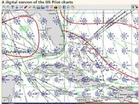
To know which routes the sailing ships took, you need to study the pilot charts, like the one below.

There is one pilot chart for each month of the year. There you can see the prevailing winds, the wind direction, wind speed , calms and current direction and current speed.

Remember, it was very difficult for the sailing ships to sail against the wind. either they had to sail a different route during one part of the year, or only sail during the good season.
 

Attachments

  • Pilot chart.webp
    Pilot chart.webp
    107.1 KB · Views: 411
Oceanscience said:
To know which routes the sailing ships took, you need to study the pilot charts, like the one below.

There is one pilot chart for each month of the year. There you can see the prevailing winds, the wind direction, wind speed , calms and current direction and current speed.

Remember, it was very difficult for the sailing ships to sail against the wind. either they had to sail a different route during one part of the year, or only sail during the good season.

Thanks so much,
I'll get on it
 

I am sure they had a monthly pilot chart printout back in the 1600 and 1700s! Back then they really didnt know where they were to go. They usually went up between Florida and Andros if leaving from Havana. But prior to that, they left from santo domingo and Jamaica and up from Central America, and they did go up through the bahamas. Outside or through, there is proof they went there. If stopping at Mexico, they usually went the Bahama Channel, up the East coast of Florida, but of course, not always.
 

Last edited:
I studied the actual Pilot Guides from the Archive of the Indies in Seville. In the 17th century the galleons leaving Havana traveled west along the coast between Cuba and Andros Is. This is called the "Old Bahama Channel." It is actually the route that Christopher Colombus took west from San Salvador. This is a narrow channel and difficult to maneuver during a storm. There are countless wrecks on the north side (Murchior Banks) in shallow water. Thats where Art McKee found the "pitch barrel wreck." The Spaniards were slow to learn and eventually went the route of the "New Bahama Channel" parallel to the coast of Florida. They discovered the Gulfstream Current and gained an extra 2 knots heading north.
 

Top Member Reactions

Users who are viewing this thread

Latest Discussions

Back
Top Bottom