Finding existing active mineral claim coordinates?

Hi-Sluicer

Greenie
Joined
Sep 29, 2017
Messages
11
Reaction score
15
Golden Thread
0
Primary Interest:
All Treasure Hunting
Im not new to any of this just wondering if anyone will share information websites where i can find coordinates for claims. Ive tried the diggings and mindat with no success. I dont want to dig on someone elses claim and after being on site it seemed claims were everywhere but not clearly marked, posts broken no markers indicating claim number owner or anything other than stakes and flags however i know i was in the right area and there were tailings everywhere. You could even see the deposits in the benches and sluice runs from old timers
 

Upvote 0
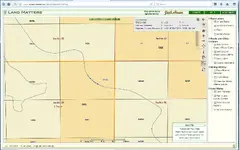
I use My Land matters zoom in on location then select the 'i" and click on a "section"
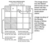
you can get a fairly good idea by reading what 1/4 section the claim is in, ie NW 1/4, SW 1/4 ect...
to get accurate claim lines you would then go to the county recorder and search claim Location by Township Range Section.
each location document will have a "description" that looks like E1/2 of the W1/2 of the SW1/4
then you can mark that on your section map,
TRS map, one section;
22-claim-staking.webp
 

Last edited:
I use My Land matters zoom in on location then select the 'i" and click on a "section"
you can get a fairly good idea by reading what 1/4 section the claim is in, ie NW 1/4, SW 1/4 ect...
to get accurate claim lines you would then go to the county recorder and search claim Location by Township Range Section.
each location document will have a "description" that looks like E1/2 of the W1/2 of the SW1/4
then you can mark that on your section map,
TRS map, one section;
View attachment 1608885

What Winner58 said....and... mining claims are not usually recorded using coordinates, BLM doesn't accept them.
 

To answer your question directly, there is NO site which will give you the coordinates of claims. It’s all on paper.
 

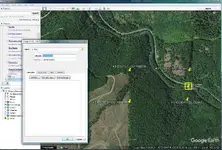
Once you have the description of a claim you can use PLSS second division then you can write down the coordinates of the corners
or where the claim lines cross a road or creek to enter into a GPS or use push pins like in Google earth.
I always like having the full Forest service paper maps of an area, helps to compare with, draw, put notes on...
.
coordinates.webp . gps.webp

* 20 acres -
S1/2 of the NE1/4 of the NE1/4 sec. 27
 

Last edited:
Thank you guys i appreciate the help. I was able to triangulate a claim using all my material and find the markers accurately
 

Thank you guys i appreciate the help. I was able to triangulate a claim using all my material and find the markers accurately

Isn’t that a great feeling when you walk up on a marker?

Well done!
 

Top Member Reactions

Users who are viewing this thread

Back
Top Bottom