Re: FRENCHMEN'S GOLD (Coudersport, Potter County)
I've studied, checked maps, read the various versions of this legend, compared other events and so on for years, off and on.
I spent a lot of time exploring areas, driving back roads, fishing...lol...since I was in high school. That was back in the late 60's early 70's. Ive continued traveling to Potter County over the years for various reasons for the last 40 years, including the star parties at Cherry Springs.
I've hiked through Austin down to Costello, a part of Roulette, Coudersport and the Borie Valley.
It is a fact that back in the late 1600's, the French were working with the Jesuits in claiming land for the king. They planted lead plates along the Allegheny River claiming the area for the king of France.
This is about the same time the legend takes place of the burried gold. The Jesuits kept a written journal of the lead plate burials. I read the translated copy. Why no written journal of the burried gold? Could there be simply confusion between fact and fiction? Lead plates become burried gold?
The problem with what the curiator says about the rock being demo'ed is, they would have found the gold during the road building with all the earth movement they would have had to do in grading, leveling and debris removal. How deep do you think they would have burried the gold when they had intentions of returning and collecting?
If they had headed to the Borie Valley, it surely isn't the easiest way to the Genesse. Further, there just isn't the big rocks like the one "as big as a house" in that valley. There is a neat little family cemetary in Ayer's Hill, which is in the valley. Not suprisingly, it's called Ayer's Hill Cemetary. It's well maintained, or was back in the mid 1980's, and has off by itself a slave burial marker. Reads something like "here lies (so and so)?, he was a good slave". As you can tell, that left a life long impression on me.
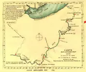
And the other thing about this legend, they didn't have the benifit of aerial photos or surveys with GPS, or any kind of even the simplest of road maps. Any maps you look at from that era are all extremely vague. You have to remember they didn't have any kind of aerial advantage of where they were while boating and hiking through an area with no landmarkers of any kind.
One hill looked much the same as the other, peering through dense woods. Just how many valleys run off the Allegheny river heading north? Quite a few! Just look at the modern topos. There are several prominant valleys that go for miles heading north. If you're toting gold, even 100 pounds through rugged terrain, it would be exhaustive. They could probably travel few miles a day with full rations, equipment, gold....
Even the shallowness of the rivers back then....lots of raft pulling, portaging, etc. And you're going against the current in rocks.
Ever raft down Ohio Pile and get to the shallows and have to drag your raft across them with the current? Even that, I found, is a challenge. Talk about beating up your legs on rocks...OUCH!
I tried snorkeling at the Indian God rock for one of those lead plates the French burried. Late summer, low water, and I still could not hold myself in place because of a strong current. And that was only a few feet from shore.
I believe that plate is still there, just that it's probably under a couple thousand tons of RR fill.
But anyhow...maybe those travelers with the gold were just lost and made up names for where they were...or thought they were

The Allegheny river flows up to New York from Pennsylvania, then South again. Why would they travel so much further south when they were already so far north, had they followed the Allegheny that far?
Wouldn't it had made more sense to take another river flowing south, before you got all the way to Coudersport? Keep heading north? Again, look at modern topos. I'm sure had they come across a wide valley heading north, thinking they would portage at some point to the Genesse, they would have gone up a valley before they got to Coudersport....kind of like Port Allegheny or even Portage Pa.
I don't doubt the legend, just the accurate location.
I think they would have stuck with deeper waters flowing south to take their northern route, mainly for ease of transport, if they had a heavy load. Reguardless of whether we call it a river, stream or creek now, if it had a high flow rate, to them that spells easier moving.
Besides legends, I have yet to see an actual reference to a document written by any of the explorers or countries of origin. There is documentation of those lead plates I mentioned. I read the references myself so I know it's factual. With so much supposed witness to the cross carved into a rock, why isn't there some historical documentation somewhere to confirm it's actual existence?
Paul Henson wrote of this legend in his book of Lost Treasures of Pennsylvania, but he didn't reference any documentation. I even wrote to him, telling him that Borie Vally wasn't a reasonable place for any burried treasure by a house sized rock. He never responded.
I even detected a few big rocks, "house sized" in Roulette. I figured after 300 years, any carving would have been obliterated over the years from weather or erosion and moss growth.
Those hills leading out of the valleys are steep and trecherous in many places. If you were toting gold, how far uphill are you willing to lug it, especially steep mountains? How long would it take you to just go a half mile through dense woods and rocks, twisting and turning, tripping, fallen trees and whatever other hazards you come upon in a wilderness situation?
Walk a mile in their shoes....then best guess where the gold might be.
I spent a lot of years with this in my mind....I wont find it in my life time...lol...if it's truely there

Al