G Bay - ILHA DA TRINDADE?, OU UMA ILHA CHAMADA TRIDADE.

I, in particular, have documents that prove the search for the alleged treasure on Trindade Island before the publication of the alleged script in 1896 (1889/1892/1894/1895).
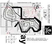
Desde Que se Formou o (POIT) Na Ilha da Trindade, Na Ociosidade e Folga, Vários Oficiais se Aventuram na Prospecção Ocular, e no Mínimo Com uma Picaretinha na Busca do Suposto Tesouro, É Certo Que Nunca Encontraram o Dito Cujo.
 

Last edited:
Since the POIT was formed on Trindade Island, in idleness and leisure, several officers venture into eye prospecting, and at least with a pickaxe in search of the supposed treasure, it is certain that they never found said cujo.
Então Vamos Voltar Ao o Que Entereça!, Tomara Que Interece Para Vocês! "O Mapa"
 

Last edited:

Attachments

  • Jornal_A_Noite_-_19.01.1940.webp
    Jornal_A_Noite_-_19.01.1940.webp
    1 MB · Views: 40
Last edited:
I can't refer here to 30 years of research, however, I have all the supporting documents of what I'm talking about OK.
 

Last edited:
Não possso me Referir Aqui a 30 Anos de Pesquisas, Entretanto, Tenho Todos os Documentos Comprobatórios do Que Estou Falando OK.
The Map Is Not by Zulmir/Zulmiro, The Map Was Made By An Englishman, (It Cannot Be A Russian/Slavo/Polish Man), Surely Freemason! A Course Departing From Another Land/Island, Which Makes It Impossible To Be The Island Of Trindade, Because It Would Have To Have Started From Argentina Or Africa And Even Codified, Clearly Indicates The True North: Only Some Unwary Can't See.
 

Last edited:
The Map Isn't Zulmir/Zulmiro, The Map Was Made By An Englishman, (It Cannot Be A Russian/Slav/Polish), With Sure Mason!, Pirate/Slavery, By Order Or Own, Indicates Two Islands, A Course Departing From Another Land/Island, Which Makes It Impossible To Be The Island Of Trindade, Because It Would Have To Have Started From Argentina Or Africa And Even Codified, Clearly Indicates The True North: Only Some Unwary Can't See.
 

Last edited:
Want to Do It Right! First Study, Research, Better Contribute Than Confound.
 

Last edited:
O Roteiro do Suposto Pirata, É Totalmente Inconfiável e Confrontando Com o Mapa!, Maior Ainda! Fica Por Conta de Cada Um, Fazer Ideia!.
 

Last edited:
O Roteiro do Alegado Pirata, Totalmente Não Confiável e Confrontando o Mapa!, Ainda Maior! Cabe a cada um, faça uma ideia!.
Uma Ilha Chamada Trindade? Pode ser Qualquer Ilha Que Você Consiga Código Dentro do Roteiro.,Quem! Até Hoje Decodificou? ; O Interessante é Que Já Escreveram Um Monte de Livros, Pegaram Carona Nas Diversas Pesquisas Abandonadas.
 

Last edited:
Precisava Expor Certas Passagens Antes De Postar o Real; Estou Aberto Para Qualquer Pergunta OK. Só Não Vou Revelar o Local.
 

Attachments

  • d1.webp
    d1.webp
    91.5 KB · Views: 47
  • origem.2.webp
    origem.2.webp
    83.2 KB · Views: 45
  • origem.3.webp
    origem.3.webp
    88.9 KB · Views: 43
  • origem.4.webp
    origem.4.webp
    68 KB · Views: 44
  • trindade 3.webp
    trindade 3.webp
    112.9 KB · Views: 46
Last edited:
Desculpe! Mas Necessário Expor Certas Passagens Antes de Lançar o Real; Estou Aberto Para Qualquer Pergunta OK.
Note Note that in the drawing of the map, even being coded in a geographically wrong position, there is an original southwest bay; Which has to be rotated along with the key, becoming original again after decoding. (Southwest bay of Grande Ponta or Pedra)
Taí 25 Anos, Perdindo Tempo Com o Suposto Roteiro Do Pirata, e Estudando o Mapa.
 

Last edited:
Here's 25 Years, Wasting Time With The Supposed Pirate Script!
Which! Improved! Went to Open the Window Between Stupidity and the Obvious!
 

Last edited:
Ó Que! Melhorou! Foi Abrir a Janela Entre a Burrice e o Óbvio!
I want to make it clear! Some Signs (3) and Information Contained in the Map, Have Consonances With the Figures and Words (3) Codified in the Supposed Script, Several Primordials; Not Necessarily Meaning Belong to the Same Story Okay.
 

Last edited:
tn_moved_over.gif
I moved ya from NEW MEMBER INTRODUCTIONS over to TREASURE LEGENDS for more exposure.

tn_notice.gif
NOTE: Forum NEW MEMBER INSTRODUCTIONS Description: This section contains guides tutorials on how to use the new TreasureNet.com software.
 

Quero Deixar Claro! Alguns Signos (3) e Informações Contidas no Mapa, Tem Consonâncias Com As Cifras e Palavras (3) Codificadas No Suposto Roteiro, Várias Primordiais.

tn_moved_over.gif
Mudei você de NOVAS APRESENTAÇÕES DE MEMBROS para TREASURE LEGENDS para mais exposição.

tn_notice.gif
NOTA: Fórum INSTRUÇÕES PARA NOVOS MEMBROS Descrição: Esta seção contém tutoriais sobre como usar o novo software TreasureNet.com.
Obrigado!
 

Last edited:
There is the possibility that the map has been ordered, as a simple map, and later geographically coded, as a place to store valuables and documents. Belonging to Pirates and Slavers of the Period of the Brazilian Empire, from 1828.
 

Last edited:
(G - Bay) G= 3 = 7 = Origin. = Island "A" = 182 - - - = 14°(Slope) = 3°E. (Declination) = 11°SE. (Towards complement), B = Island "B" = 2135 = 11

Note Note Tip/Base Slope Relative to Top of Sugarloaf Mountain = 14°SW angle. and That Island "B" Is Tilted At 11°SW.
 

Attachments

  • origem.5..webp
    origem.5..webp
    115.2 KB · Views: 44
Last edited:
G Bay, unless you post in English very few will respond.

G Bay, a menos que você traduza para o inglês do português, muito poucos responderão.
 

G Bay, a menos que você poste em inglês, poucos responderão.

G Bay, a menos que você traduza para o inglês do português, muito poucos respondedores.
Can you check if it got better?
 

Top Member Reactions

Users who are viewing this thread

Latest Discussions

Back
Top Bottom